


")


 География
Похожие презентации:


")


Stratigraphy and Correlation
1. Stratigraphy and Correlation
Reservoir Evaluation and ManagementStratigraphy and Correlation
Natalia Kaumova
2017
hw.tpu.ru
2. Content
•2Content
Data, Stratigraphy and Models
Graphic Correlation
Reservoir Architecture and Reservoir Performance
Exercises
3. Introduction
•3Introduction
Correlation – the identification of certain intervals
in one well which relate to equivalent intervals
in a second or subsequent wells:
– usually same geological age
– often (but not always) same lithological character
• Light tables and computer correlation techniques
• Artform rather than science
• Geological experience/judgement critical
4. Introduction
•4Introduction
• Depends on the aims and methods
• Always is a subject of change with extra information
5. Importance of correlation
•5Importance of correlation
You need to correctly correlate lithofacies in the
subsurface in order to
• identify flow units and to map the distribution, thickness
and continuity of reservoir and seal facies
• estimate reservoir volume, porosity, permeability
distributions and therefore fluid volume
6. Data
•6Data
• Wireline logs (well tops and lithology) are is a primary (hard) data
(usually needs preparation)
• Biostratigraphic (chronostratigraphic) data
• Seismic often is the only way to get an idea of interwell communication
pattern
Выделение тектонических нарушений с помощью стандартных временных разрезов, на
которых видны смещения осей синфазности отражающих горизонтов, а также затухание
амплитуд вдоль субвертикальных линий.
Важность знаний о наличии и положении разломов для разработки месторождений
трудно переоценить: они могут являться тектоническими экранами и оказывать решающее
влияние на потоки как извлекаемой нефти, так и закачиваемой воды.
7. Data
•7Data
Compare the complexity of Helder and Hoorn Fields
(Roelofsen et al., 1991)
8. Data preparation
•8Data preparation
• Wire log data transformation to True Vertical Depth
(TVD) or TVDSS (subsea)
KB
Vertical distance from kelly bushing
to sea level
MD
Measured depth. Measured distance
along the path of wellbore from
kelly bushing to any point in the
subsurface
TVD
True vertical depth. Vertical
distance from kelly bushing to any
point in the subsurface
TVDSS True Vertical Depth Subsea.
Vertical distance from mean sea
level to any point in the subsurface
• Альтитуда - высота точки местности над уровнем моря (среднемноголетний уровень моря),
определяемая Нивелированием.
9. Why normalize scales?
•9Why normalize scales?
MD gives thicker units
than TVD, meaning that
correlations drawn using
MD are distorted
10. Wireline Logs
•10Wireline Logs
Caliper – кавернометрия, результатом измерения является кавернограмма — кривая, отражающая
изменение диаметра скважины с глубиной.
Mud log - диаграмма удельного сопротивления бурового раствора.
Dipmeter - определение в скважине азимута и угла падения пластов. Азимут и угол наклона пластов
определяют в скважине с помощью специального глубинного прибора — пластового наклономера.
Sonic (АК) – измеряет скорость пробега упругих волн в породе. Если известна литология, позволяет
рассчитать пористость. Совместно с нейтронным позволяет определить вторичную пористость.
GR – это по сути индикатор глин, и обычный инструмент для корреляции. (но не отличает радиактивные
минералы от глины, искажая значение содержания глин).
11. Data preparation
•11Data preparation
• Different purpose
– GR – lithology (sand vs clay)
– Resistivity – saturation character and quantity
– Sonic – lithology (hard or soft) and seismic markers
recognition
– Caliper – sometime lithology and other log data
reliability
– Dipmeter – bedding (sometime fractures) orientation;
deformation and faults can be recognized
– Mudlog – lithology (cuttings), hydrocarbon shows
12. Stratigraphy
•12Stratigraphy
• Lithostratigraphy: most widely used (still), allows arrangeing
facies, porosity and permeability zones. / раздел стратиграфии,
использующий для расчленения разрезов и прослеживания выделенных
литостратиграфических подразделений особенности вещественного
состава осадочных, вулканогенно-осадочных и эффузивных толщ.
• Biostratigraphy: fossil assemblages used for correlation and
(usually) dating the rocks / раздел стратиграфии, изучающий
распределение в осадочных толщах ископаемых остатков организмов
с целью выяснения относительного возраста этих отложений.
• Chronostratigraphy: using a timelines of sedimentation / раздел
стратиграфии, имеющий дело с установлением относительного
возраста и возрастных соотношений геологических тел.
• Magnetostratigraphy: correlation of zones with the same polarity.
• Chemostratigraphy: use of chemical/isotopic markers/ раздел
науки на стыке химии и стратиграфии, занимающийся изучением
химического состава осадочных пород.
13. Stratigraphic principles
•13Stratigraphic principles
• Uniformitarianism: The present is the key to past
• Sedimentary rocks are deposited horizontally
• Sedimentary beds continue laterally until they
pinch-out depositionally
• Unconformities may represent the greatest
amount of geological time
Теоретическую основу стратиграфии составляют два принципа:
закон напластования Стено и закон соответствия флоры и фауны
Гексли. Согласно закону напластования, введённому в науку
Николасом Стено в XVII веке, выше лежащие пласты горных пород,
как правило, являются более молодыми, чем залегающие глубже.
Согласно принципу Гексли, слои, в которых содержатся
ископаемые остатки одинаковых видов живых организмов, имеют
одинаковый возраст.
14. Stratigraphic principles
•14Stratigraphic principles
• Law of Superposition: in any sedimentary succession that
has not be overturned, the oldest rock will be at the bottom
and the youngest at the top / породы находящиеся в не
нарушенном складчатостью и разломами залегании, следуют в
порядке их образования, породы залегающие выше моложе, а те
которые находятся ниже по разрезу — древнее.
• Walther’s Law: Sedimentary facies occurring in a
conformable stratigraphic succession were deposited in
laterally adjacent depositional environment.
/ Только такие фации
и фациальные обстановки
могут залегать друг на друге
в геологическом разрезе,
которые в современных
условиях лежат рядом.
15. Lithostratigraphy
•15Lithostratigraphy
Lithostratigraphic unit – a stratum or body of strata, usually
layered, often tabular, that conforms to the law of
superposition and is defined on the basis of lithic
characteristics and stratigraphic position
Lithology – the physical characteristics of a rock, including
colour, mineralogy, grain size, textures, structures and so on.
for example: this
correlation implies
that between these
two points this
bedding plane is
continuous
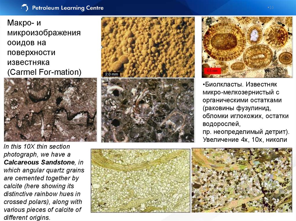
16.
•16Макро- и
микроизображения
ооидов на
поверхности
известняка
(Carmel For-mation)
•Биолкласты. Известняк
микро-мелкозернистый с
органическими остатками
(раковины фузулинид,
обломки иглокожих, остатки
водорослей,
пр. неопределимый детрит).
Увеличение 4х, 10х, николи
In this 10X thin section
photograph, we have a
Calcareous Sandstone, in
which angular quartz grains
are cemented together by
calcite (here showing its
distinctive rainbow hues in
crossed polars), along with
various pieces of calcite of
different origins.
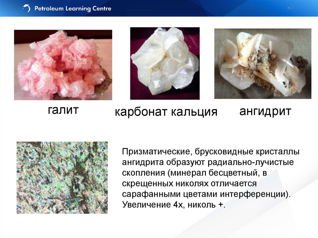
17.
•17галит
карбонат кальция
ангидрит
Призматические, брусковидные кристаллы
ангидрита образуют радиально-лучистые
скопления (минерал бесцветный, в
скрещенных николях отличается
сарафанными цветами интерференции).
Увеличение 4х, николь +.
18. Lithostratigraphy
•18Lithostratigraphy
• The same lithology does not always mean that the rocks
were deposited at the same time, often lithology is
environment sensitive, not time sensitive, so that lithologic
units are often time transgressive (occur at different times
in different places)
• Lithology reflects deposition environment
19. Lithostratigraphy
•19Lithostratigraphy
Formal lithostratigraphic terms in increasing scale:
– Member (пачка) - smallest locally mappable unit (within field)
– Formation (свита) - mappable unit at the basin scale
– Group (серия) - mappable across several basins
Stratigraphic framework of the region
Пачка — относительно небольшая по мощности совокупность слоев (пластов),
характеризующихся некоторой общностью признаков или одним определенным
признаком, которые отличают ее от смежных по разрезу пачек в составе свиты
(подсвиты) или толщи.
Свита — основная единица местных стратиграфических подразделений, представляет
собой совокупность развитых в пределах какого-либо геологического района отложений,
которые отличаются от ниже- и вышележащих составом и структурами пород,
обусловленных их генезисом, комплексом остатков организмов, пр.
Серия объединяет две или более свиты, образующие крупный цикл осадконакопления и
(или) охарактеризованные какими-либо общими признаками: сходными условиями
формирования (морские, континентальные, вулканические), преобладанием
определенных пород (осадочные, магматические, метаморфические) или их
направленной сменой.
20.
•20Западно-Сибирская нефтегазоносная
В строении Западно-Сибирской
провинция
нефтегазоносной провинции
принимают участие
метаморфизованный фундамент
докембрийско-палеозойского возраста
и полого залегающий мезокайнозойский осадочный чехол.
Фундамент погружается от
периферии к центру плиты, в пределах
которой в соответствии с
мощностями чехла и характером
платформенных структур выделяют
несколько тектонических элементов.
•Москва
•Х.-Мансийск
•Тюмень
•Стрежевой
•Томск
MZ-KZ
PZ
21.
•21Stratigraphic section of Mesozoic
rocks of West Siberian basin
Stratigraphic section of Mesozoic rocks of West Siberian basin
(Gregory F. Ulmishek)
22. Lithostratigraphy: markers
•22Lithostratigraphy: markers
• Stratigraphic markers are widespread units or
boundaries that may be recognized and
correlated over an area – that must have been
deposited all at the same time (simultaneously)
over the entire basin
abrupt lithology change (Bazhen Fm)
platform limestones
shallow-marine sandstone (not basin-wide)
coal beds in deltaic successions
excellent marker – tephra (volcanic ash)
23. Lithostratigraphy: non-markers
•23Lithostratigraphy: non-markers
• Channel sandstones
• Reefal limestones (across the body)
(Рифовые
—
жизнедеятельности
обязанные
своим
прикрепленных
происхождением
ко
дну
водоема
колониальных рифостроящих организмов, выделяющих для
постройки своего скелета углекислую известь).
• Fluvial coals (sometime are only markers can be used)
• Alluvial fan deposits (отложения конусов выноса)
• Mudstones (if difficult to distinguish between them).
24. Lithostratigraphy: markers
•24Lithostratigraphy: markers
1. The top of the Bridport Sandstone Formation is marked by a thin, easily
recognisable, high radioactivity unit (Inferior Oolite Formation) at 911,6 m.
2. The Gamma Ray and Sonic log have been used for the basis of a
Composite Log
25. Lithostratigraphy: markers
•25Lithostratigraphy: markers
• Clear wireline log response and good acoustic contract with under- and
overlying rocks – Limestone Member of Frome Clay Fm
методы (НГК, ГГКП) отражают общую пористость пород, а АК –
только ее межзерновую часть
26. Missing sections: normal faults
•26Missing sections: normal faults
Drilled succession
True succession
• Well №1 shows reduced
section because of
normal fault penetrated
(from Tearpock and Bischke, 1991)
• Dipmeter would be
useful to recognize the
fault plane
27. Repeated sections: reverse faults
•27Repeated sections: reverse faults
(from Tearpock and Bischke, 1991)
Drilled succession
NOTE: structural features are
not only reasons for repeating
sections!
True succession
Dipmeter would be useful to
recognize the fault plane
28. Correlation Guideline
•28Correlation Guideline
• Beware of probable differences in resistivity logs response due to the
saturation
• Always correlate from the base to top – as the rocks were deposited
• Always correlate from the large scale to smaller scale – worry first about
formation top and markers
• Check for missing and repeated sections
• Always correlate both the top and bottom of a bed/formation
• Pinching out units indicated by merging lines (< or >)
• Never correlate top and bottom of the well – northing common with the
stratigraphy
• Check for mudstone (shale) color change in the mudlog
• Keep in eye caliper log as locating damaged (permeable) rock and
probable loss of the other logs quality
• Dipmeter sudden response change may indicate faults or unconformity
• Volcanoclastic is one of the best marker
• Non-geological features (scale change, casing shoes, sonic log cycle skip)
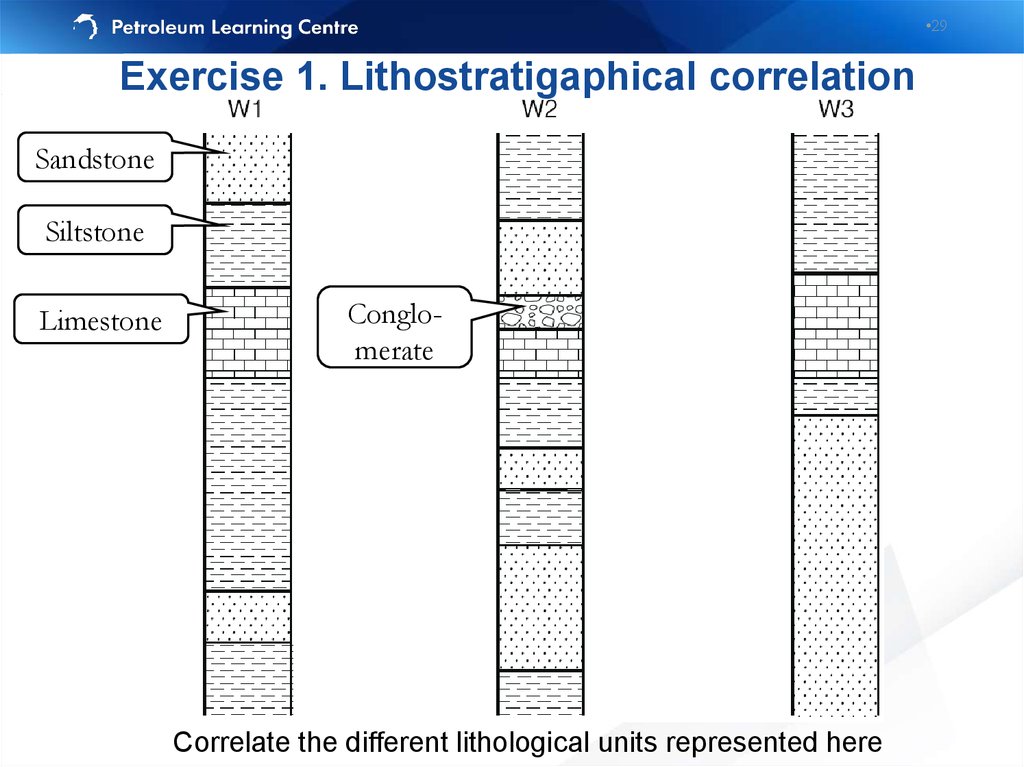
29.
•29Exercise 1. Lithostratigaphical correlation
Sandstone
Siltstone
Limestone
Conglomerate
Correlate the different lithological units represented here
30. Exercise 1. Lithostratigaphical correlation
•30Exercise 1. Lithostratigaphical correlation
This is one of possible answers
31. What have we just done?
•31What have we just done?
We have
decided that the
subsurface in
the region
represented by
these three logs
looks something
like this:
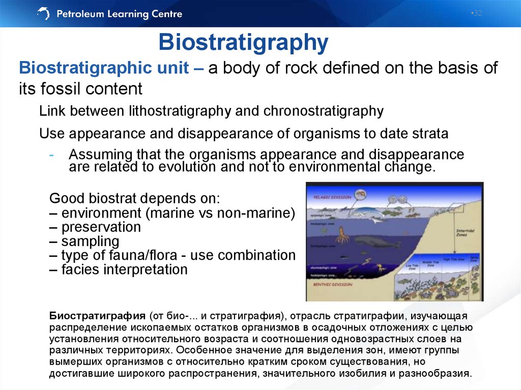
32.
•32Biostratigraphy
Biostratigraphic unit – a body of rock defined on the basis of
its fossil content
Link between lithostratigraphy and chronostratigraphy
Use appearance and disappearance of organisms to date strata
- Assuming that the organisms appearance and disappearance
are related to evolution and not to environmental change.
Good biostrat depends on:
– environment (marine vs non-marine)
– preservation
– sampling
– type of fauna/flora - use combination
– facies interpretation
Биостратиграфия (от био-... и стратиграфия), отрасль стратиграфии, изучающая
распределение ископаемых остатков организмов в осадочных отложениях с целью
установления относительного возраста и соотношения одновозрастных слоев на
различных территориях. Особенное значение для выделения зон, имеют группы
вымерших организмов с относительно кратким сроком существования, но
достигавшие широкого распространения, значительного изобилия и разнообразия.
33. Biostratigraphical correlation
•33Biostratigraphical correlation
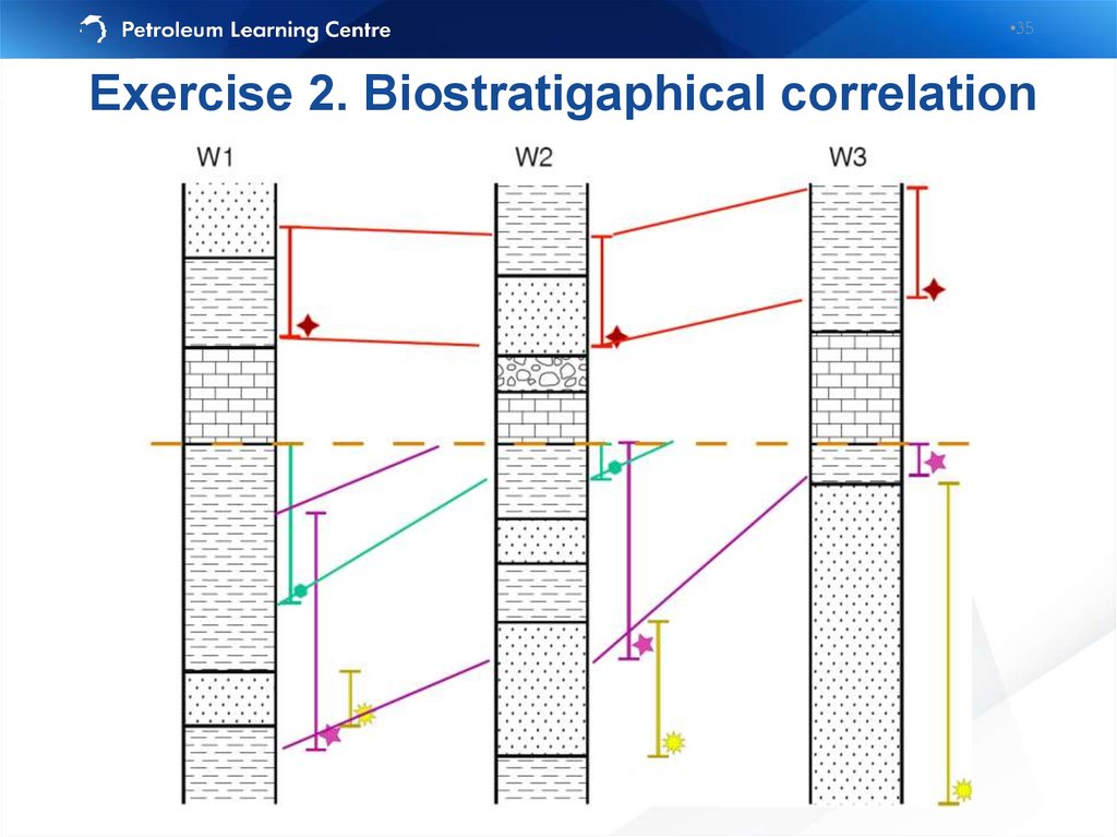
34. Exercise 2. Biostratigraphical correlation
•34Exercise 2. Biostratigraphical correlation
Correlate the
biostratigraphic
markers
represented by the
symbols (first and
last appearance of
the organisms)
Корреляция в
стратиграфии — это
установление
одновозрастности или
возрастных
соотношений (моложе/
древнее)
сопоставляемых
стратиграфических
подразделений.
35.
•35Exercise 2. Biostratigaphical correlation
36. Magnetostratigraphy
•36Magnetostratigraphy
Normal polarity
Reversed polarity
(computer simulation, Glatzmaier and Roberts, 1995)
• Magnetic minerals in sedimentary rocks tend to be deposited according to the
Earth magnetic field
• Earth magnetic field’s polarity change over the time
• Today’s polarity referred as a “normal” – black zones (in contrast to the
“reversed” – white zones)
• Магнитостратиграфия (палеомагнитный метод) — наука, изучающая расчленение
отложений горных пород на основе их прямой или обращенной намагниченности.
37. Magnetostratigraphy
•37Magnetostratigraphy
• Магнитное поле
Земли или геомагнитное поле —
магнитное поле, генерируемое
внутриземными источниками.
• Точки Земли, в которых
напряжённость магнитного поля имеет
вертикальное направление,
называют магнитными полюсами.
Таких точек на Земле две: северный
и южный магнитные полюса.
• Подобно тому, как окаменелости и отпечатки организмов, живших в
геологическом прошлом, позволяют изучать историю развития органического
мира, синхронизировать содержащие их пласты и определять возраст этих
пластов, "Окаменелый геомагнетизм" - намагниченность J горных: пород позволяет изучать историю магнитного поля Земли.
• Палеомагнитология изучает магнитное поле Земли геологического прошлого,
закрепленное в своеобразных отпечатках этого поля — векторах естественной
остаточной намагниченности горных пород, которые фиксируют магнитное
поле времени и места образования горных пород. В истории Земли многократно
происходили инверсии магнитного поля, когда векторы первичной
намагниченности (Jn) менялись на 180°, т.е. северный магнитный полюс
становился южным и наоборот.
38.
•38Thickness of the zones
depends both on it’s duration
and sedimentation rate.
Общая магнито-стратиграфическая
шкала (англ. general
magnetostratigraphic scale) –
хронологическая последовательность
магнитозон полярности, привязанная к
подразделениям Общей
стратиграфической шкалы.
Осадки формируются с разной
скоростью: чем медленнее
формировалось отложение, тем
тоньше эта магнитостратиграфическа зона. И чем быстрее –
тем, мощность больше.
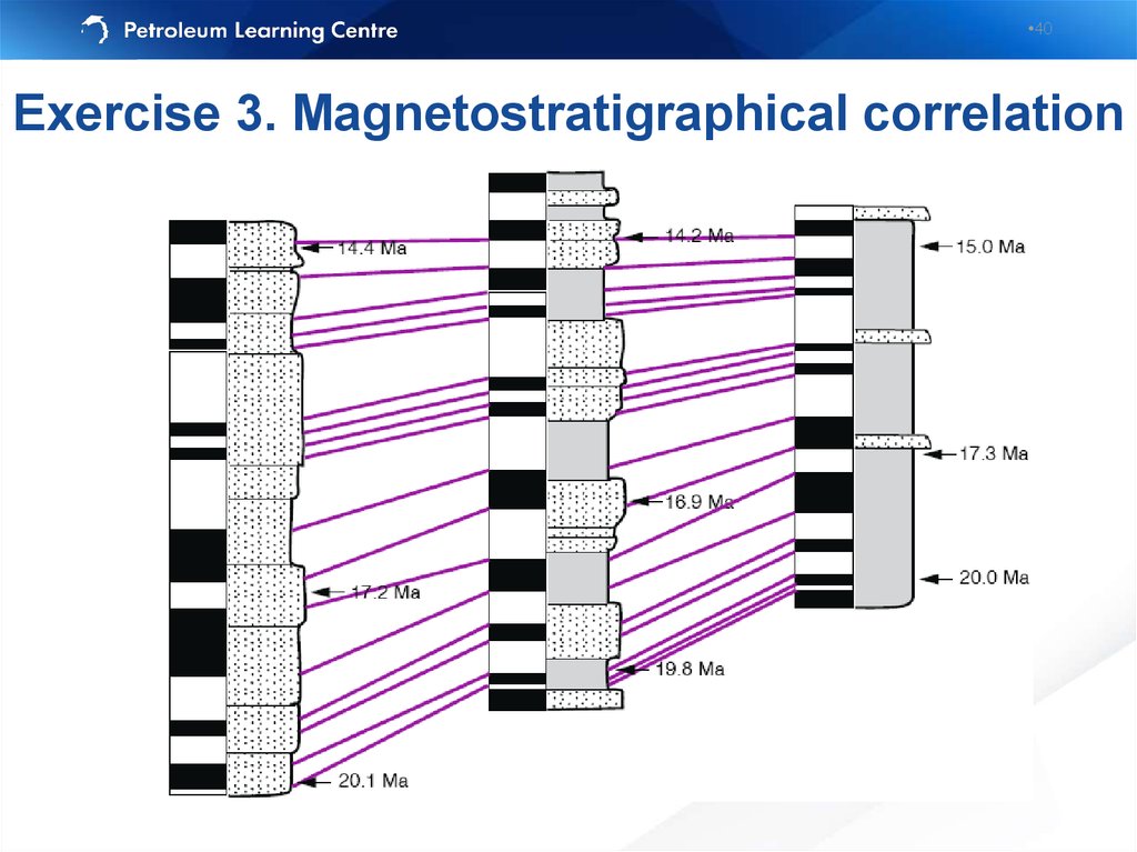
39. Exercise 3. Magnetostratigraphical correlation
•39Exercise 3. Magnetostratigraphical correlation
Черный цвет - нормальная намагниченность,
белый цвет - обратная намагниченность
40.
•40Exercise 3. Magnetostratigraphical correlation
41. Chronostratigraphy
•41Chronostratigraphy
Chronostratigraphic unit – a body of rock laid down at the same time.
(Хроностратиграфия (гр. chronos - время, лат. stratum - настил, слой и
гр. grapho - пишу) - раздел стратиграфии, имеющий дело с установлением
относительного возраста и возрастных соотношений геологических тел).
Formal chronostratigraphic terms in increasing length of time:
– Stage - smallest unit of defined time (Volgian)
– Epoch - Upper Jurassic
– Period - longer period (Jurassic)
– Era - Largest time period (Mesozoic)
42. Chronostratigraphy vs. Lithostratigraphy
•42Chronostratigraphy vs. Lithostratigraphy
43.
44. Seismic Stratigraphy
•44Seismic Stratigraphy
• Correlation of seismic packages bounded by
truncations of reflection events
• Advantages
- Continuous interpretation in inter-well areas
• Disadvantages
- Limited resolution, uncertainty as to what seismic
truncations really mean, must be ‘tied’ to well
information for lithology and age
Целью сейсмостратиграфического анализа является определение
условий и обстановок осадконакопления по особенностям волновой
картины на сейсмических разрезах отраженных волн
45. Reservoir Limits
•45Reservoir Limits
Stratigraphic pinch-out of reservoir unit
(Thompson and Butcher, 1991)
46. Seismic facies
•46Seismic facies
Пример палеоканалов (русел)
(Черное море, вал Шатского)
Пример вероятной рифовой постройки
(Черное море, вал Шатского)
(Никишин А.М.)
47. Основные типы несогласий
•47Основные типы несогласий
Эрозионное срезание (erosional
truncation) — залегание
вышележащих отложений выше
поверхности эрозии.
Кровельное утыкание (toplap) —
срезание моноклинально
залегающей толщи сверху более
пологой эрозионной
поверхностью Кровельное утыкание обычно связано с эрозией
или перерывом в седиментации.
Согласное залегание —
несогласие, когда слоистость
параллельна поверхности
несогласия.
Подошвенное прилегание (onlap)
— прилегание (прислонение)
толщи слоев на поверхность,
наклонен-ную в ту же сторону, что
и слои, но более круто.
Подошвенное налегание
(downlap) — несогласие, когда
слоистая толща наклонена и
книзу утыка-ется в более пологую
поверхность.
48. Raw Data
•48Raw Data
Initial
FinalInterpretation
Results
49. Sequence Stratigraphy
•49Sequence Stratigraphy
Sequence stratigraphy is the study of genetically related
fades within a framework of chronostratigraphically
significant surfaces
Sequence stratigraphy processes can exert a strong
influence on the geometry, continuity, quality and location
of reservoir
50. Sea-level changes
•50Sea-level changes
Eustatic sea level is a distance from the sea surface to
the fixed datum, usually the center of the Earth. It can vary
by changes in the volume of ocean basins or changes in the
volume of water within those basins (эвстати́ческие колеба́ния
уровня моря - медленные (вековые) изменения уровня Мирового океана и
связанных с ним морей, вызываемые изменением количества воды в
океане вследствие образования или таяния ледниковых масс, а также
меняющегося объёма океанических впадин).
Relative sea level is a distance between
the sea surface and reference horizon
such as basement, controlled by:
- Tectonic subsidence or uplift
- Eustatic movement of sea-level
The distance between the
sediment/water interface and the sea
surface is known as water depth.
51. Accommodation space
•51Accommodation space
Accommodation is defined by Jervey (1998) as "the space available
for potential sediment accumulation"
This space is the combined product of movement of:
• The sea surface (eustasy: global sea level measured from a datum
such as the center of earth)
• The sea floor (tectonics)
• Changes in rates of sediment accumulation
Can be
filled with
sediments
and water
Это то возможное, пространство, где потенциально может накапливаться
осадок. Контролируется тектоническими подвижками, климатическими
условиями, эвстатическими колебаниями уровня моря, мощностью осадка.
52. Sediment Deficient
•52Sediment Deficient
53. Excess Sediment
•53Excess Sediment
54. Parasequence
•54Parasequence
Парасиквенс (или парасевенция) – это мелеющая вверх последовательность
слоев, ограниченная поверхностями морского затопления. По сути – это
регрессивный циклит.
Upward-coarsening: bedsets
thicken, sandstones coarsen,
and the
sandstone/mudstone ratio
increases upward
Upward-fining: bedsets thin,
sandstones become finer grained
(commonly culminating in
mudstones and coals), and the
sandstone/mudstone ratio
decreases upward.
55. Parasequence set
•55Parasequence set
Пакетом парасеквенций назывся последовательность парасеквенций по вертикали, имеющих определенный тип напластования – проградационный, аградационный или ретроградационный.
Проградационный
пакет парасеквенций
направлен в сторону
бассейна и носит
регрессивный
характер.
Ретроградационный
направлен в
противоположную
сторону и носит
трансгрессивный
характер.
Агградационный
характеризуется
стабильным
положением
береговой линии.
56. Chronostratigraphy vs. Lithostratigraphy Progradational parasequence set
•56Chronostratigraphy vs. Lithostratigraphy
Progradational parasequence set
57. Chronostratigraphy vs. Lithostratigraphy Retrogradational parasequence set
•57Chronostratigraphy vs. Lithostratigraphy
Retrogradational parasequence set
58.
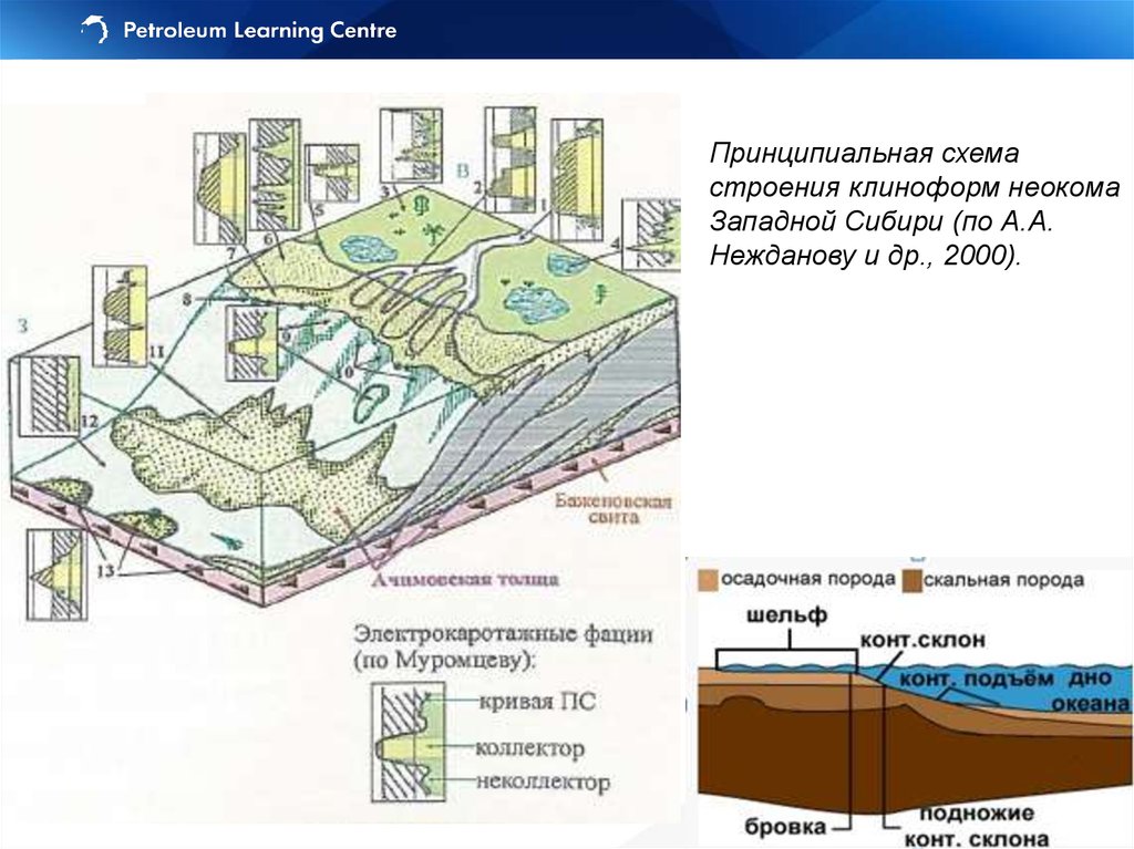
Принципиальная схемастроения клиноформ неокома
Западной Сибири (по А.А.
Нежданову и др., 2000).
59. Sequence Stratigraphy
•59Sequence Stratigraphy
• “A sequence is a stratigraphic unit composed of a relatively
conformable succession of genetically related strata and
bounded at its top and base by unconformities or their
correlative conformities” (Sloss, 1963). Относительно
согласная последовательность генетически взаимосвязанных
слоев, ограниченных несогласиями или коррелятивно связанными
с ними согласными поверхностями.
• Parasequences and parasequence sets are the stratal
building blocks of the sequence
60. Depositional Systems Tracts: LST
•60Depositional Systems Tracts: LST
LST = Lowstand Systems Tract: sea level drop, continental shelf
subaeral erosion, shelf margin wedge, facies boundary shift
toward the sea. (Тракт низкого стояния образуется при падении уровня моря
до наименьшего состояния и осушения шельфа. Основная седиментация
происходит за счет быстрого транспорта обломочного материала в область
подножия континентального склона. При этом осадконакопление происходит в
глубоких частях бассейна, где формируется донный конус выноса).
61. Depositional Systems Tracts: TST
•61Depositional Systems Tracts: TST
TST = Transgressive Systems Tract: sea level rise, maximum
flooding surface (MFS), facies boundaries shift towards the
land, retrogradational parasequence set
62. Depositional Systems Tracts: HST
•62Depositional Systems Tracts: HST
HST = Highstand Systems Tract (sometime Regressive Systems
Tract): sea level rise, stabilizing and starting to fall, commonly
consist of an aggradational parasequence set.
(Тракт высокого стояния – море стабильно затопляет шельф, перекрывая
осадочным материалом. Подошва ТВС/HST– поверхностью максимального
затопления).
63. Sequence Stratigraphy
•63Sequence Stratigraphy
High sea-level:
• Flooding surfaces
• Deposition of reservoir close to shore
• Reservoir marker events – marine shales
Low sea-level:
• Exposure of shelf, incision, erosion
• Deposition of reservoir in deep water
• Reservoir marker events – unconformities
64.
•64Sequence stratigraphic surfaces
• The subaerial unconformity
is an
unconformity that forms under subaerial
conditions as a result of fluvial erosion or
bypass, pedogenesis, wind degradation, or
dissolution and karstification.
•The correlative conformity is a marine stratigraphic surface that marks the
change in stratal stacking patterns from highstand normal regression to
forced regression. It is the paleo-seafloor at the onset of forced regression
•The maximum flooding surface (is a stratigraphic surface that marks a
change in stratal stacking patterns from transgression to highstand normal
regression. It is the paleo-seafloor at the end of transgression, and its
correlative surface within the nonmarine setting. Alternative terms include:
ʻfinal transgressive surfaceʼ, ʻsurface of maximum transgressionʼ.
•The regressive surface of marine erosion is an erosional surface that
forms typically by means of wave scouring during forced regression in
wavedominated shallow-water settings due to the lowering of the wave
base relative to the seafloor.
65. Stratal elements in Hierarchy
•65Stratal elements in Hierarchy
66. Hierarchical arrangement of stratal elements
•66Hierarchical arrangement of stratal elements
continental:
–
–
megasequence
supersequence
basin:
–
–
–
sequence
depositional
systems tract
parasequence set
reservoir:
–
–
–
–
–
parasequence
bedset
bed
laminaset
lamina
(adapted from van Wagoner et al., 1990)
67. Hierarchical arrangement of stratal elements
•67Hierarchical arrangement of stratal elements
continental:
–
–
megasequence
supersequence
basin:
–
–
–
sequence
depositional systems
tract
parasequence set
reservoir:
–
–
–
–
–
parasequence
bedset
bed
laminaset
lamina
68. Sequence Stratigraphy Terminology
•68Sequence Stratigraphy Terminology
69. Терминология
•69Терминология
70. Correlation and Environmental Interpretation
•70Correlation and Environmental Interpretation
Accurate correlations depends on a little
knowledge of the environment of deposition of
the sediments:
“In different environments, the geometry and extent of
sediment bodies is different”
For example in marine settings sand bodies
may extend several kilometres, but in fluvial
settings they would rarely be wider than a few
hundred metres as each body represents a
channel fill.
71.
•71Correlation and Environmental
Interpretation
Shallow Marine
Cook Fm., L. Jur.
From Livbjerg and Mjos, in
Collinson, 1989
Fluvial-deltaic
Ness Fm., M.Jur.
From Ryseth, in Collinson,
1989
72. Exercise 4. Different Environments
•72Exercise 4. Different Environments
Shallow-marine deposits
73. Exercise 4. Different Environments
•73Exercise 4. Different Environments
Fluvial deposits
74. Exercise 4. Different Environments
•75Realism in correlations
Impossible scenario
75. Realism in correlations
•76Graphic Correlation
• Stratigraphic relationships are easier to display if you
align the logs so that correlated rocks or units more-orless line up. This is called hanging, and usually means
that the sections are aligned so that a specific horizon
or boundary is horizontal. For example…
Datum
76. Graphic Correlation
•77Correlation panels or cross sections?
A correlation panel:
• equally spaced wells
• wells have been hung
A cross-section:
• spacing of wells reflects
distance between wells
• actual arrangement in
space of the wells
77. Correlation panels or cross sections?
•78Correlation panel
78. Correlation panel
•79Cross-section
79. Cross-section
•80Graphic Correlation
Fence diagram: actual position of the wells
80. Graphic Correlation
•81Graphic Correlation
Block-diagram (well location needed) – either 3-D
image of current geology/geography, or interpretations
of facies relationships, geological evolution etc.
(combines map information with a cross section).
81.
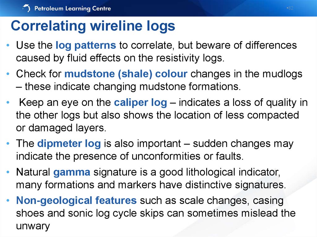
•82Correlating wireline logs
• Use the log patterns to correlate, but beware of differences
caused by fluid effects on the resistivity logs.
• Check for mudstone (shale) colour changes in the mudlogs
– these indicate changing mudstone formations.
• Keep an eye on the caliper log – indicates a loss of quality in
the other logs but also shows the location of less compacted
or damaged layers.
• The dipmeter log is also important – sudden changes may
indicate the presence of unconformities or faults.
• Natural gamma signature is a good lithological indicator,
many formations and markers have distinctive signatures.
• Non-geological features such as scale changes, casing
shoes and sonic log cycle skips can sometimes mislead the
unwary
82. Correlating wireline logs
•83Non-geological features
83. Non-geological features
•84Correlating wireline logs
84. Correlating wireline logs
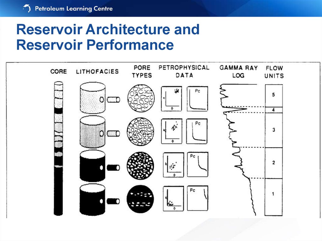
•85Reservoir Architecture and
Reservoir Performance
Flow unit is a mappable portion of total reservoir
within which geological and petrophysical properties
that affect the flow of fluids are consistent and
predictably different from the properties of other
reservoir rock volumes (modified from Ebanks, 1987)
A flow unit zonation integrates
geological, petrophysical and
production data
85. Reservoir Architecture and Reservoir Performance
•86Reservoir Architecture and
Reservoir Performance
Flow units concepts:
1.
Have the same
petrophysical
properties
2.
Recognizable on
logs and
correlatable
between wells
3.
Include non-pay
and pay and the
fluids therein
86.
Reservoir Architecture andReservoir Performance
87. Reservoir Architecture and Reservoir Performance
•88Reservoir Architecture
Geologically realistic model from Weber and van Geuns (1990)
Three (clastic) reservoir types:
Layercake – Layered reservoirs:
Low permeability contrasts between vertically
stacked layers which are laterally extensive
Jigsaw – Mixture of high and low permeability
sedimentary layers and bodies:
variable overlap of high permeability bodies,
variable difference of permeability vertically and
horizontally
Labyrinth – Isolated high permeability bodies
within low permeability ‘background’:
variable overlap of high permeability bodies,
variable difference between sandbodies and
background sediment
88. Reservoir Architecture Geologically realistic model from Weber and van Geuns (1990)
•89Reservoir Architecture
Deterministic model can be
used for correlation
Simple to model
89. Reservoir Architecture
•90Reservoir Architecture
Deterministic model hardly
can be used for correlation –
probably stochastic approach
(or combination of both)
needed for petrophysical
modeling as well
90.
•91Reservoir Architecture
•Connectivity between sand
bodies is related to the
proportion of sand in the
vertical section
•The modelling is complex
91.
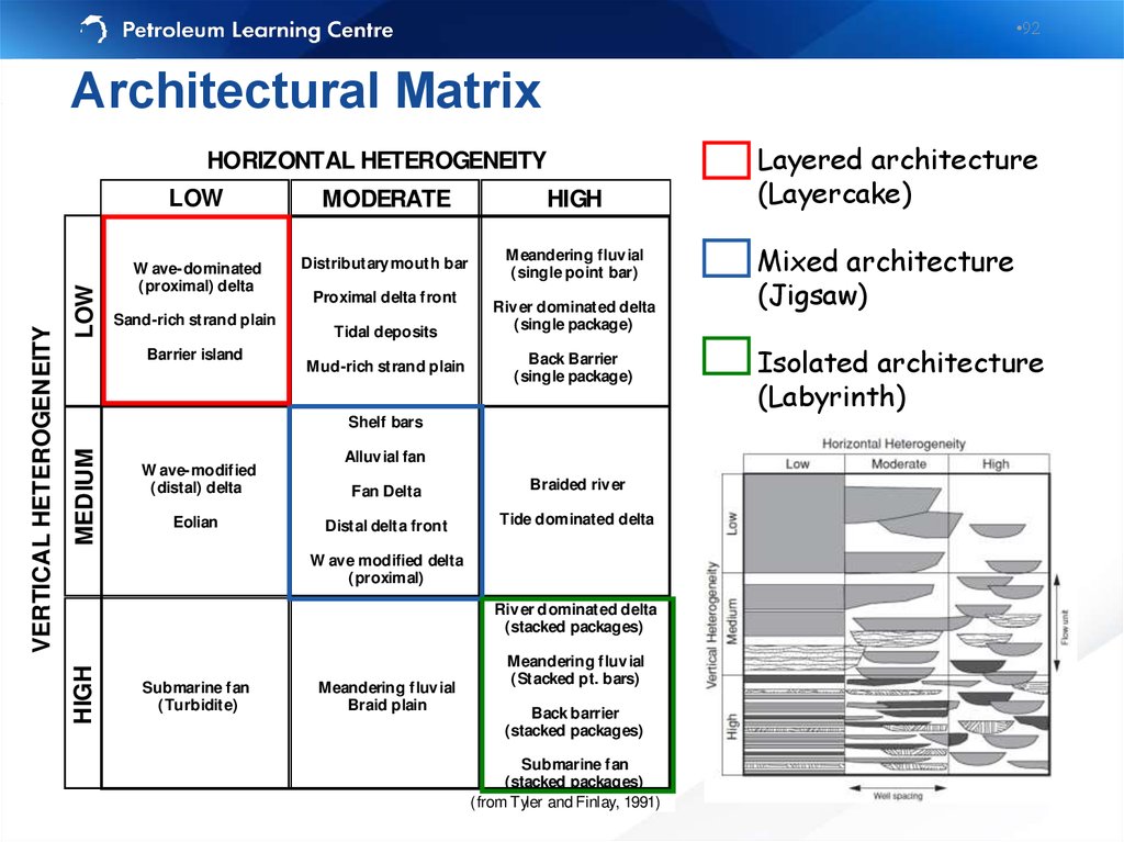
•92Architectural Matrix
LOW
LOW
MODERATE
HIGH
W ave-dominated
(proximal) delta
Distributary mouth bar
Meandering fluv ial
(single point bar)
Sand-rich strand plain
Barrier island
Proximal delta front
Tidal deposits
Mud-rich strand plain
Riv er dominated delta
(single package)
Back Barrier
(single package)
MEDIUM
Shelf bars
W ave-modified
(distal) delta
Eolian
Alluv ial fan
Fan Delta
Braided riv er
Distal delta front
Tide dominated delta
W ave modified delta
(proximal)
Riv er dominated delta
(stacked packages)
HIGH
VERTICAL HETEROGENEITY
HORIZONTAL HETEROGENEITY
Submarine fan
(Turbidite)
Meandering fluv ial
Braid plain
Meandering fluv ial
(Stacked pt. bars)
Back barrier
(stacked packages)
Submarine fan
(stacked packages)
(from Tyler and Finlay, 1991)
Layered architecture
(Layercake)
Mixed architecture
(Jigsaw)
Isolated architecture
(Labyrinth)
92. Architectural Matrix
•93Recovery as a function of geology
NORTH SEA RESERVOIRS
Debris flow (Brae)
Turbidite (Magnus)
Submarine fan (Forties)
Shallow marine (Piper)
Fluvial (Crawford)
Submarine fan (Andrew)
Aeolian (Auk)
Turbidite (Katrine)
Lacustrine (Lewis)
Shallow Marine (Fulmar Sd)
Shallow marine (Piper Sd)
0
Water Injection
Jigsaw
Layercake
Labyrinth
Primary Recovery
Jigsaw
Layercake
20
40
60
80
93. Recovery as a function of geology
•94Compartmentalisation
• Sedimentary structures or stratal architecture (facies models)
Turbidites (Forties), fluvial reservoirs (Brent Ness Formation),
deltas etc…
• Faulting
Seismically resolvable faults (Gullfaks)
Sub-seismic faulting (Thistle)
• Combination - faulting and architecture (NW Hutton)
• Some fields have no compartments
Measurements techniques:
• Formation pressure testers to detect pressure discontinuities and
variations in contacts
• Geochemistry to detect variations in oil properties
• Tracer testing
94. Compartmentalisation
•95Learning objectives
1. Identify correlation markers
2. Correlate lithological units between wells using
lithology and wireline log information
3. Understand how interpretation of depositional
environment affects correlation of rock units
4. Describe the role of different data (seismic, log,
biostrat)and models (sequence strat.) on correlation
5. Describe pitfalls in correlation
Correlation is the step before mapping - Exercises give
useful experience
95. Learning objectives
•96Exercise 6-8: Correlation
• It involves:
6: Correlation and hanging
7: Faulted sections
8: Structural vs stratigraphic cross-sections
96. Exercise 6-8: Correlation
•97Дополнительные слайды
97.
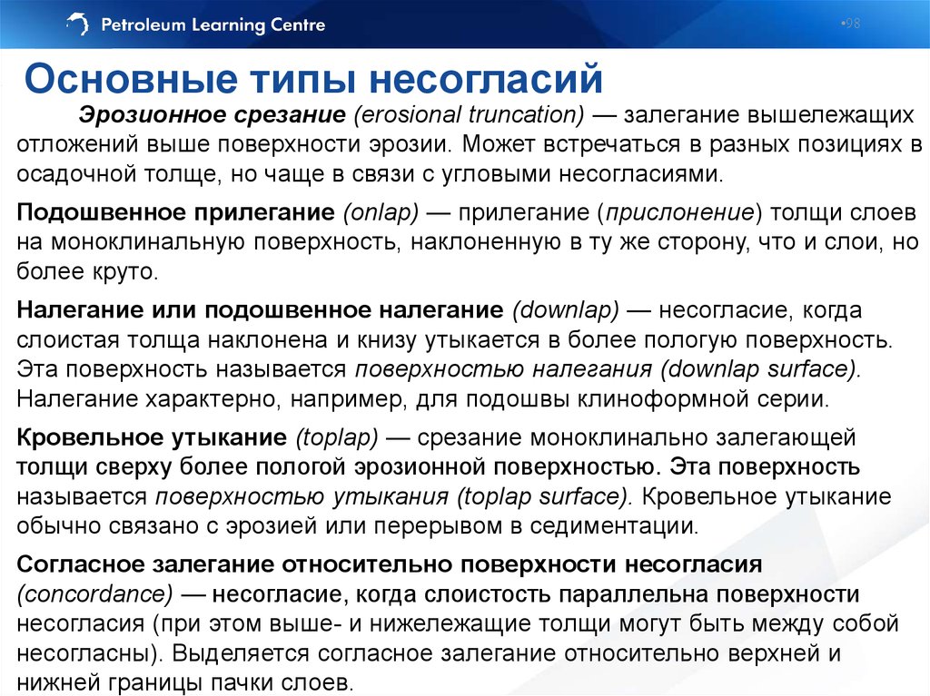
•98Основные типы несогласий
Эрозионное срезание (erosional truncation) — залегание вышележащих
отложений выше поверхности эрозии. Может встречаться в разных позициях в
осадочной толще, но чаще в связи с угловыми несогласиями.
Подошвенное прилегание (onlap) — прилегание (прислонение) толщи слоев
на моноклинальную поверхность, наклоненную в ту же сторону, что и слои, но
более круто.
Налегание или подошвенное налегание (downlap) — несогласие, когда
слоистая толща наклонена и книзу утыкается в более пологую поверхность.
Эта поверхность называется поверхностью налегания (downlap surface).
Налегание характерно, например, для подошвы клиноформной серии.
Кровельное утыкание (toplap) — срезание моноклинально залегающей
толщи сверху более пологой эрозионной поверхностью. Эта поверхность
называется поверхностью утыкания (toplap surface). Кровельное утыкание
обычно связано с эрозией или перерывом в седиментации.
Согласное залегание относительно поверхности несогласия
(concordance) — несогласие, когда слоистость параллельна поверхности
несогласия (при этом выше- и нижележащие толщи могут быть между собой
несогласны). Выделяется согласное залегание относительно верхней и
нижней границы пачки слоев.
98. Основные типы несогласий
•99Seismic unconformities
99. Seismic unconformities
•Thank youNatalia Kaumova
•Petroleum Learning Centre
Heriot-Watt Approved Learning Partner
•hw.tpu.ru
info@hw.tpu.ru