Похожие презентации:
Decision-making processes and evaluation
1.
LVIV POLYTECHNIC NATIONAL UNIVERSITYCourse: Evaluation of assets by different techniques, using IT
DECISION-MAKING PROCESSES AND EVALUATION
Prof. Francesca Nocca
University of Naples Federico II, Italy
francesca.nocca@unina.it
2.
DECISION MAKING PROCESSES AND EVALUATIONSECTIONS OF THE LECTURE
SECTION I
• Decision-making processes and evaluation: an overview
• Focus on multicriteria evaluation methods
SECTION II
• Case study: Real Estate Market Dynamics in the City of Naples (Italy)
SECTION III
• Conclusions
3.
DECISION-MAKING PROCESSES AND EVALUATION: AN OVERVIEW4.
WHAT DOES IT MEAN TO EVALUATE?Whenever the individual is called upon to make a decision, he or she is faced with a problem of
choosing among several alternative options, including the option of non-intervention, that is, he/she
is forced to carry out a process of evaluation among several possibilities in order to identify the
PREFERABLE ONE. It is not possible, therefore, to separate the issue of choice from that of
evaluation (Costanza et al., 1997).
Evaluation is the set of activities oriented
toward the appropriate organization of the
information necessary for choice, such that
each actor in the decision-making process is
able to make the most balanced decision
possible (Nijkamp et al., 1990).
Evaluation in design consists of comparing
design alternatives to deduce the overall most
desirable design hypothesis, that is, the one
that comes closest to the ''ideal project''
(Zeleny, 1982).
DECISION-MAKING PROCESSES AND EVALUATION |
5.
WHAT DOES IT MEAN TO EVALUATE?Evaluation is a strategic activity at different levels and a fundamental tool for:
⮚ scientific support for decision-making processes to make appropriate choices and rationalize
programs and actions;
⮚ ex-ante, on-going and ex-post verification of the actual achievement of planned objectives in
terms of quantity, costs, efficiency, effectiveness, quality of processes and products, and impacts
aimed at continuous improvement;
⮚ guarantee with respect to users, investments and society as a whole.
DECISION-MAKING PROCESSES AND EVALUATION |
6.
THE INTERNATIONAL FRAMEWORKDECISION-MAKING PROCESSES AND EVALUATION |
7.
WHEN TO EVALUATE?T- 1
T1
T2
T3
Planning
Implementation
Managment
Ex ante
Evaluation
On going
Evaluation
Ex post
evaluation
POSITIONING IN THE DECISION-MAKING PROCESS
EX ANTE
ON GOING
EX POST
Before the action (project, plan, etc.) is outlined and
implemented; to verify whether it is appropriate
and/or feasible.
After the action (project, plan, etc.) has been
outlined and while it is being implemented; to check
whether the progress corresponds to what was
planned.
After the action (project, plan, etc.) has been
implemented and has produced results; to check
whether it has produced the expected results or even
unexpected results.
OBJECTIVE
Planning
Monitoring
Monitoring and
feedback
8.
MULTICRITERIA EVALUATION METHODS9.
MULTIDIMENSIONAL EVALUATIONSEvaluation methods help to choose "which" project or plan or strategy is PREFERRED over others, "to what extent“,
and "for whom“, making policymakers, public and private actors, and interested social groups more aware of the
various types of consequential effects of individual actions.
MONETARY APPROACHES
ECONOMIC
DIMENSION
FINANCIAL ANALYSIS
COST-BENEFIT ANALYSIS
CULTURAL
DIMENSION
SOCIAL
DIMENSION
COST-EFFECTIVENESS ANALYSIS
NON-MONETARY APPROACHES
ENVIRONMENTAL
DIMENSION
MULTICRITERIA ANALYSIS
DECISION-MAKING PROCESSES AND EVALUATION |
10.
MULTICRITERIA EVALUATION METHODSMCDA
Multi-Criteria Analysis (MCDA) is a branch of Operations Research (OR) that is used to evaluate
multiple criteria and conflicting opinions in decision making. MCDA uses mathematical approaches
to formalize problems and uses operational steps to solve them. Its main strength is inherent in its
ability to aggregate diverse data, information, criteria and conflicting views into synthetic results.
Multi-criteria analyses are a decision support tool. They allow dealing with complex problems
characterized by uncertainty and monetary and nonmonetary, quantitative and qualitative
information.
GIS and Regional Science
Sustainability
Medicine
Statistics
Medical Technology
Figure source: Poli, 2022
DECISION-MAKING PROCESSES AND EVALUATION |
11.
THE ELEMENTS OF DECISION MAKING PROCESSGOALS
CRITERIA
INDICATORS
Objectives represent the purpose intended to
be achieved through the implementation of
the plan/project.
They derive from various factors (e.g., from
the interpretation of the knowledge
framework).
The criteria are the operational translation of
the objectives.
They represent the different points of view by
which interventions can be evaluated.
The weight is the relative importance
assigned to each criterion.
An indicator is a parameter that can represent,
alone or in combination with others, the
general characteristics of a criterion or
element (e.g., environmental), which cannot
be measured directly.
Indicators can be quantitative or qualitative.
ALTERNATIVES
STAKEHOLDER
An alternative describes the object of the
decision, that is, that to which decision
support is directed.
The concept of an alternative corresponds
to the special case in which the
formalization is such that two separate
potential actions cannot be implemented
together.
A stakeholder is any individual (person, group
of people, institution, association, or company)
whose interests, opinions, and contributions
may further or hinder the achievement of
project objectives by potentially enacting
positive attitudes or negative attitudes.
Stakeholders (stakeholders) represent the
different-and often conflicting-viewpoints
within a decision-making process. Each
stakeholder has its own system of values and
preferences.
EXPERT
KNOWLEDGE
COMMON
KNOWLEDGE
Indicators, in their broadest sense, can be
defined as those parameters that serve to
describe a given phenomenon quantitatively and
qualitatively. (UN, 2007)
Indicator can be defined as a parameter, or a
value derived from parameters, that provides
information about a given phenomenon.
(OECD, 1997)
12.
CASE STUDY: THE CITY OF NAPLES, ITALY13.
REAL ESTATE MARKET DYNAMICS AND URBAN REGENERATION IN THE CITY OF NAPLES, ITALYTERRITORIAL FRAMEWORK: ITALY, CAMPANIA REGION, CITY OF NAPLES
The city of Naples is a municipality of almost one
million inhabitants, part of the Metropolitan City
of Naples.
It is rich in valuable cultural and nature heritage,
and its historic centre was on the UNESCO World
Heritage List since 1995.
Focusing attention on the city of Naples (Italy), the purpose of this research work to analyse in detail the real estate
dynamics in this city through the integration of a Multi-Criteria Decision Analysis (MCDA) method and
Geographical Information System (GIS). This integration allowed us to map and analyse the territory, linking a
specific issue (the real estate dynamics) to the territory itself, and to analyse it according to specific criteria. This aims
for a better understanding and interpretation of real estate dynamics, representing a useful tool for orienting and
supporting urban planning strategies.
METHODOLOGY
HOUSING MARKET
COMMERCIAL PROPERTY MARKET
The change in market prices of housing
and commercial properties has been
analysed in relation to the 2009–2018
period (after the 2008 crisis).
We are carrying out this work to update it to
date!
14.
HOUSE PRICES2009
2012
2015
2018
15.
COMMERCIAL PROPERTY PRICES2009
2012
2015
2018
16.
PERCENTAGE VARIATIONS – HOUSE PRICES17.
PERCENTAGE VARIATIONS – COMMERCIAL PROPERTY PRICES18.
TERRITORIAL STATISTICAL ANALYSES19.
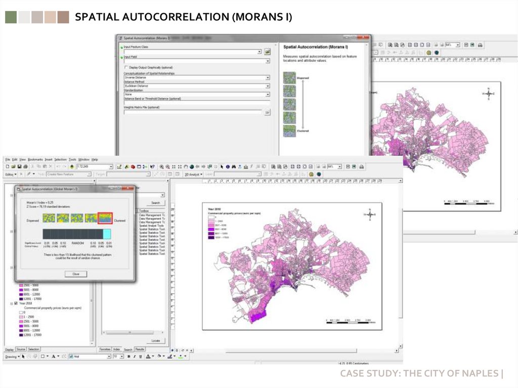
SPATIAL AUTOCORRELATION (MORANS I)CASE STUDY: THE CITY OF NAPLES |
20.
CLUSTER AND OUTLIER ANALYSIS (ANSELIN LOCAL MORANS I)Cluster and Outlier Analysis (COA) in the ArcGIS framework has been elaborated for identifying
concentrations of values and spatial outliers. It has been conducted in order to identify similarities of
behavior between data spatially close to each other.
CASE STUDY: THE CITY OF NAPLES |
21.
CLUSTER AND OUTLIER ANALYSIS – HOUSE PRICES2009
2012
2015
2018
22.
CLUSTER AND OUTLIER ANALYSIS – COMMERCIAL PROPERTY PRICES2009
2012
2015
2018
23.
HIGH/LOW CLUSTERING (GETIS-ORD GENERAL G)CASE STUDY: THE CITY OF NAPLES |
24.
HOT SPOT ANALYSIS (GETIS-ORD Gi*)The Hot Spot Analysis (HSA) has been conducted (by means of ArcGIS software) using the Getis–Ord Gi*
statistic for determining if spatial clusters are referring to high values (hot spots) or low values (cold
spots).
A hotspot is “an area that has higher concentration of events compared to the expected number given a
random distribution of events”.
CASE STUDY: THE CITY OF NAPLES |
25.
HOTSPOT ANALYSIS – HOUSE PRICES2009
2012
2015
2018
26.
HOTSPOT ANALYSIS – COMMERCIAL PROPERTY PRICES2009
2012
2015
2018
27.
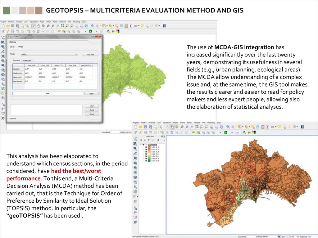
GEOTOPSIS – MULTICRITERIA EVALUATION METHOD AND GISThe use of MCDA-GIS integration has
increased significantly over the last twenty
years, demonstrating its usefulness in several
fields (e.g., urban planning, ecological areas).
The MCDA allow understanding of a complex
issue and, at the same time, the GIS tool makes
the results clearer and easier to read for policy
makers and less expert people, allowing also
the elaboration of statistical analyses.
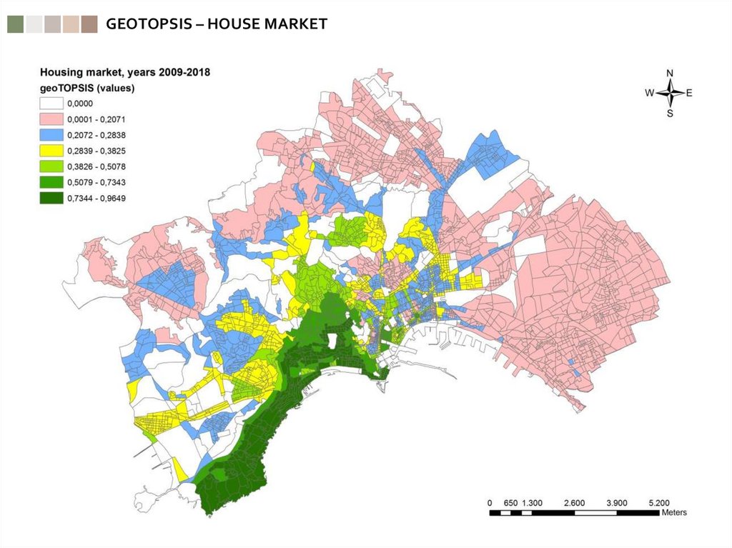
This analysis has been elaborated to
understand which census sections, in the period
considered, have had the best/worst
performance. To this end, a Multi-Criteria
Decision Analysis (MCDA) method has been
carried out, that is the Technique for Order of
Preference by Similarity to Ideal Solution
(TOPSIS) method. In particular, the
“geoTOPSIS” has been used .
28.
GEOTOPSIS – HOUSE MARKET29.
GEOTOPSIS – COMMERCIAL PROPERTY MARKET30.
PROJECTS AND SERVICES/INFRASTRCTURES31.
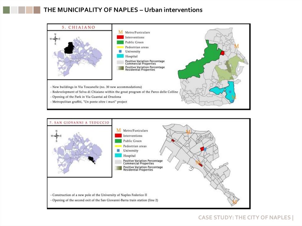
THE MUNICIPALITY OF NAPLES – Urban interventionsCASE STUDY: THE CITY OF NAPLES |
32.
THE MUNICIPALITY OF NAPLES – Urban interventionsCASE STUDY: THE CITY OF NAPLES |
33.
CONCLUSIONS34.
CONCLUSIONS⮚ The integrated evaluation approach provides an important support for a better understanding and interpretation
of urban dynamics, and to orient and activate, consequently, the appropriate planning policies, implementing
actions, and projects that are more appropriate to the “vocation” of each area.
⮚ The MCDA methods are a useful tool for evaluating alternative projects considering different criteria and
including various actors/stakeholders and points of view.
⮚ The integration of a Multi-Criteria Decision Analysis (MCDA) and Geographical Information System (GIS) allowed
us to map and analyse the territory, linking a specific issue (the real estate dynamics) to the territory itself, and to
analyse it according to specific criteria. In particular, in this work the use of geoTOPSIS allows classifying and
discretizing urban areas in order to understand which ones have maintained the best or worst performance during
the period considered. This can support decision makers in a clearer and more detailed reading of the territory in
order to identify the areas in which to plan new interventions.
⮚ The analysis at a high level of definition, such as that of census sections, can be useful for future steps of the
research, representing a base for elaborating analysis linking the real estate dynamics with other information
collected for the same sections for the census. This integrated approach can support the governance of cities and
the development of strategies for enhancing the comprehensive territorial productivity.
35.
LVIV POLYTECHNIC NATIONAL UNIVERSITYCourse: Evaluation of assets by different techniques, using IT
DECISION-MAKING PROCESSES AND EVALUATION
Prof. Francesca Nocca
University of Naples Federico II, Italy
francesca.nocca@unina.it
THANK YOU!








 Менеджмент


