


 География
 Промышленность
Похожие презентации:


Consolidated Information Report for Aral Resources Ltd
1.
Consolidated Information Report for Aral Resources Ltd.2.
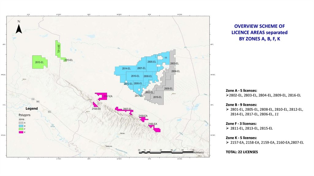
OVERVIEW SCHEME OFLICENCE AREAS separated
BY ZONES A, B, F, K
Zone A - 5 licenses:
2802-EL, 2803-EL, 2804-EL, 2809-EL, 2816-EL
Zone B - 9 licenses:
2801-EL, 2805-EL, 2808-EL, 2810-EL, 2812-EL,
2814-EL, 2817-EL, 2806-EL, 11
Zone F - 3 licenses:
2811-EL, 2813-EL, 2815-EL
Zone K - 5 licenses:
2157-EA, 2158-EA, 2159-EA, 2160-EA,2807-EL
TOTAL: 22 LICENSES
3.
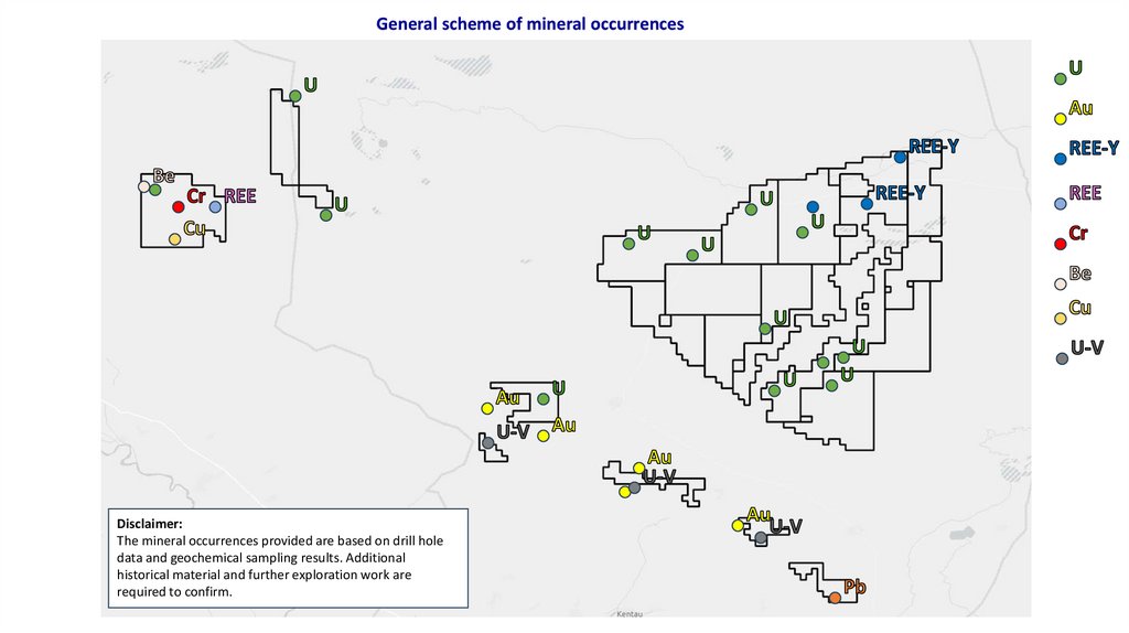
General scheme of mineral occurrencesDisclaimer:
The mineral occurrences provided are based on drill hole
data and geochemical sampling results. Additional
historical material and further exploration work are
required to confirm.
4.
Zones A and B5.
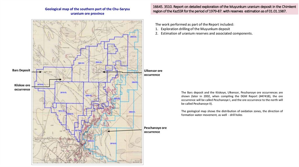
Geological map of the southern part of the Chu-Sarysuuranium ore province
16645. 3510. Report on detailed exploration of the Muyunkum uranium deposit in the Chimkent
region of the KazSSR for the period of 1979-87. with reserves estimation as of 01.01.1987.
The work performed as part of the Report included:
1. Exploration drilling of the Muyunkum deposit
2. Estimation of uranium reserves and associated components.
Bars Deposit
Ulkensor ore
occurrence
Kiiskoe ore
occurrence
The Bars deposit and the Kiiskoye, Ulkensor, Peschanoye ore occurrences are
shown (later in 2002, when compiling the DGM Report (#47418), the ore
occurrence will be called Peschanoye I, and the ore occurrence to the north will
be called Peschanoye II).
The geological map shows the distribution of oxidation zones, the direction of
formation water movement, as well - drill holes
Peschanoye ore
occurrence
6.
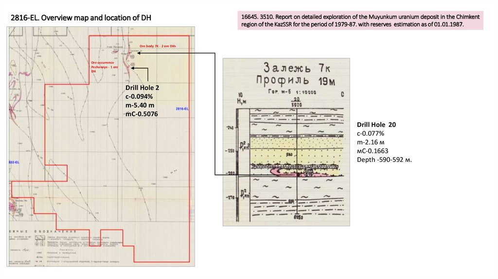
2816-EL. Overview map and location of DH16645. 3510. Report on detailed exploration of the Muyunkum uranium deposit in the Chimkent
region of the KazSSR for the period of 1979-87. with reserves estimation as of 01.01.1987.
Ore body 7K - 2 ore DHs
Ore occurrence
Pechanoye - 1 ore
DH
Drill Hole 2
с-0.094%
m-5.40 m
mC-0.5076
Drill Hole 20
с-0.077%
m-2.16 м
мС-0.1663
Depth -590-592 м.
7.
16645. 3510. Report on detailed exploration of the Muyunkum uranium deposit in the Chimkent regionof the KazSSR for the period of 1979-87. with reserves estimation as of 01.01.1987.
2809-EL. Overview map and location of DH
Залежь 1И – 3 рудные скв
Drill hole 40
с-0.012%
m-3.70 м
мС-0.0444
Depth: 468-471 м.
Drill hole 44
с-0.051%
m-0.20 м
мС-0.0102
Depth: 455 м.
Drill hole 16
с-0.014%
m-0.20 м
мС-0.0028
Depth: 455 м.
Drill hole 25
с-0.032%
m-1.70 м
мС-0.0544
Depth: 441-443 м.
с-0.055%
m-1.50 м
мС-0.0825
Depth: 466-467 м.
с-0.035%
m-1.60 м
мС-0.0560
Depth: 465-467 м.
с-0.033%
m-0.90 м
мС-0.0297
Depth: 470-471 м.
8.
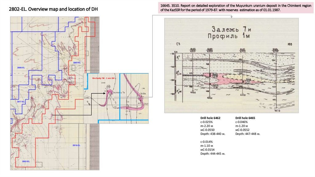
2802-EL. Overview map and location of DH16645. 3510. Report on detailed exploration of the Muyunkum uranium deposit in the Chimkent region
of the KazSSR for the period of 1979-87. with reserves estimation as of 01.01.1987.
Ore body 7И - 1 ore DH
Drill hole 6462
с-0.025%
m-2.20 м
мС-0.0550
Depth: 438-440 м.
с-0.014%
m-1.10 м
мС-0.0154
Depth: 444-445 м.
Drill hole 6465
с-0.046%
m-1.20 м
мС-0.0552
Depth: 447-448 м.
9.
16645. 3510. Report on detailed exploration of the Muyunkum uranium deposit in the Chimkentregion of the KazSSR for the period of 1979-87. with reserves estimation as of 01.01.1987.
2802-EL. Overview map and location of DH
Drill hole 7765
с-0.023%
m-4.30 м
мС-0.0989
Depth: 500-504 м.
Ore body 19К, 20К, 4И, –
9 ore DHs,
1-2 DHs per ore body
Drill hole 7763
с-0.043%
m-4.60 м
мС-0.1978
Depth: 500-505 м.
Drill hole 6795
с-0.018%
m-4.00 м
мС-0.0720
Depth: 428-432 м.
Drill hole 7506
с-0.054%
m-1.10 м
мС-0.0594
Depth: 425-426 м.
с-0.014%
m-0.40 м
мС-0.0056
Depth: 436 м.
с-0.121%
m-2.00 м
мС-0.1210
Depth: 437 м.
10.
16645. 3510. Report on detailed exploration of the Muyunkum uranium deposit in the Chimkent regionof the KazSSR for the period of 1979-87. with reserves estimation as of 01.01.1987.
2802-EL. Overview map and location of DHs
Ore body 19К, 20К, 4И, –
9 ore holes,
1-2 holes per ore body
Drill hole 7204
с-0.072%
m-1.00 м
мС-0.0720
Depth: 488-489 м.
с-0.139%
m-0.90 м
мС-0.1251
Depth: 490 м.
Drill hole 7203
с-0.035%
m-1.80 м
мС-0.0630
Depth: 495-497 м.
11.
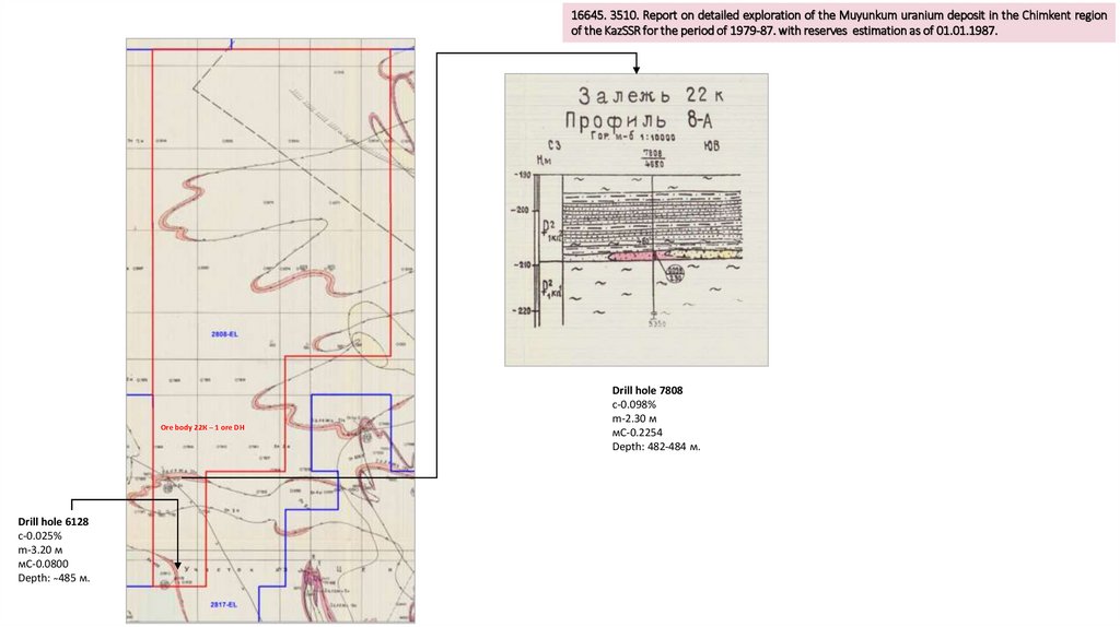
16645. 3510. Report on detailed exploration of the Muyunkum uranium deposit in the Chimkent regionof the KazSSR for the period of 1979-87. with reserves estimation as of 01.01.1987.
Ore
body22К
22К– –1 1рудная
ore DHскв
Залежь
Drill hole 6128
с-0.025%
m-3.20 м
мС-0.0800
Depth: ̴485 м.
Drill hole 7808
с-0.098%
m-2.30 м
мС-0.2254
Depth: 482-484 м.
12.
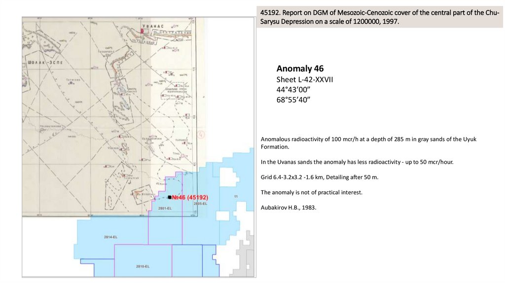
45192. Report on DGM of Mesozoic-Cenozoic cover of the central part of the ChuSarysu Depression on a scale of 1200000, 1997.Anomaly 46
Sheet L-42-XXVII
44°43’00”
68°55’40”
Anomalous radioactivity of 100 mcr/h at a depth of 285 m in gray sands of the Uyuk
Formation.
In the Uvanas sands the anomaly has less radioactivity - up to 50 mcr/hour.
Grid 6.4-3.2x3.2 -1.6 km, Detailing after 50 m.
The anomaly is not of practical interest.
Aubakirov H.B., 1983.
13.
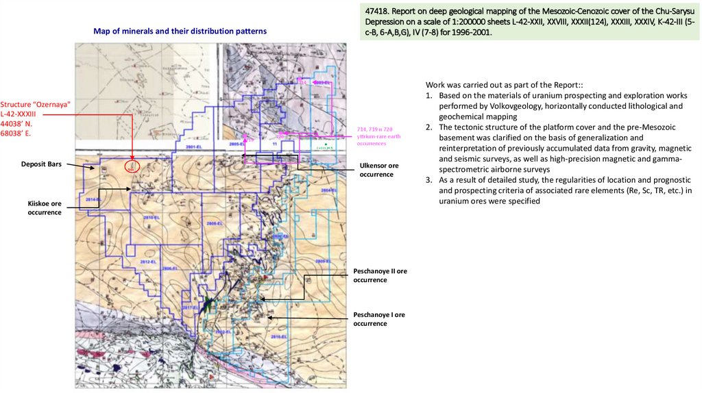
47418. Report on deep geological mapping of the Mesozoic-Cenozoic cover of the Chu-SarysuDepression on a scale of 1:200000 sheets L-42-XXII, XXVIII, XXXII(124), XXXIII, XXXIV, K-42-III (5c-B, 6-A,B,G), IV (7-8) for 1996-2001.
Map of minerals and their distribution patterns
714
Structure “Ozernaya"
L-42-XXXIII
44038’ N.
68038’ E.
719
720
Cu-0.01 (#45)
Deposit Bars
501
714, 719 и 720
yttrium-rare earth
occurrences
Ulkensor ore
occurrence
Kiiskoe ore
occurrence
Peschanoye II ore
occurrence
Peschanoye I ore
occurrence
Work was carried out as part of the Report::
1. Based on the materials of uranium prospecting and exploration works
performed by Volkovgeology, horizontally conducted lithological and
geochemical mapping
2. The tectonic structure of the platform cover and the pre-Mesozoic
basement was clarified on the basis of generalization and
reinterpretation of previously accumulated data from gravity, magnetic
and seismic surveys, as well as high-precision magnetic and gammaspectrometric airborne surveys
3. As a result of detailed study, the regularities of location and prognostic
and prospecting criteria of associated rare elements (Re, Sc, TR, etc.) in
uranium ores were specified
14.
Recommendations for Zones A and B licenses:1. No detailed information was found in the acquired historical reports to supplement the Exploration Plans
(Category 2 or 3) with drilling, trenches, and other methods. Additional historical reports are required.
2. Conduct airborne geophysics.
3. Request geological data (assay, collar, survey, lithology) from geological funds or Volkovgeology JSC.
4. Plan core drilling in areas with identified ore occurrences and uranium mineralization.
15.
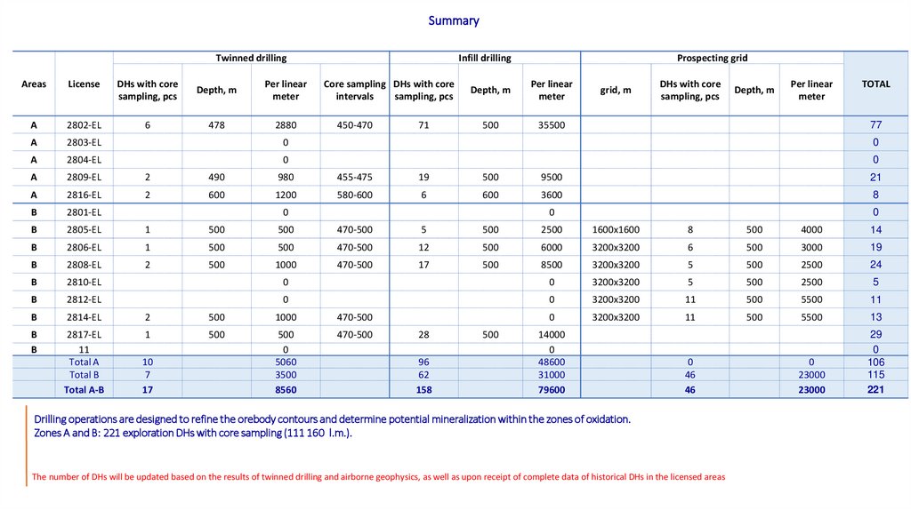
Potential Drilling Sites – Zones A and B16.
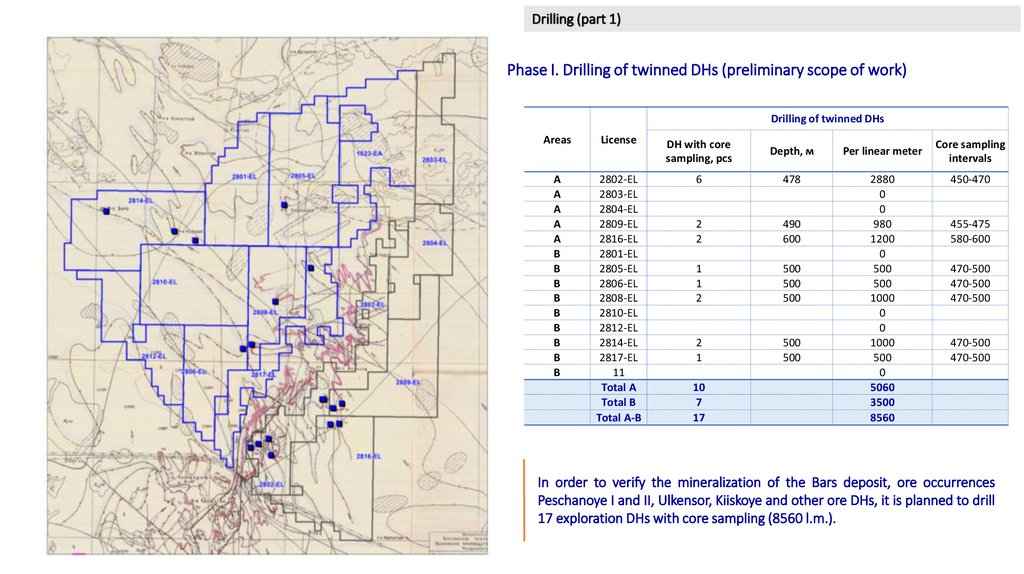
Drilling (part 1)Phase I. Drilling of twinned DHs (preliminary scope of work)
Drilling of twinned DHs
Areas
License
DH with core
sampling, pcs
Depth, м
Per linear meter
А
А
А
А
А
В
В
В
В
В
В
В
В
В
2802-EL
2803-EL
2804-EL
2809-EL
2816-EL
2801-EL
2805-EL
2806-EL
2808-EL
2810-EL
2812-EL
2814-EL
2817-EL
11
Total А
Total В
Total А-В
6
478
2
2
490
600
1
1
2
500
500
500
2
1
500
500
2880
0
0
980
1200
0
500
500
1000
0
0
1000
500
0
5060
3500
8560
10
7
17
Core sampling
intervals
450-470
455-475
580-600
470-500
470-500
470-500
470-500
470-500
In order to verify the mineralization of the Bars deposit, ore occurrences
Peschanoye I and II, Ulkensor, Kiiskoye and other ore DHs, it is planned to drill
17 exploration DHs with core sampling (8560 l.m.).
17.
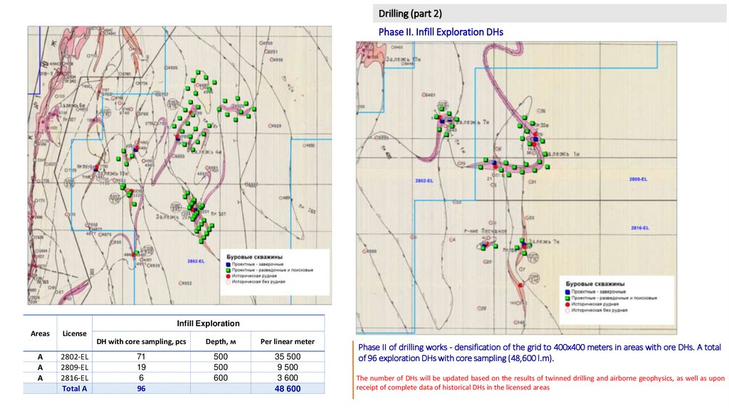
Drilling (part 2)Phase II. Infill Exploration DHs
Infill Exploration
Areas
А
А
А
License
2802-EL
2809-EL
2816-EL
Total А
DH with core sampling, pcs
Depth, м
Per linear meter
71
19
6
96
500
500
600
35 500
9 500
3 600
48 600
Phase II of drilling works - densification of the grid to 400x400 meters in areas with ore DHs. A total
of 96 exploration DHs with core sampling (48,600 l.m).
The number of DHs will be updated based on the results of twinned drilling and airborne geophysics, as well as upon
receipt of complete data of historical DHs in the licensed areas
18.
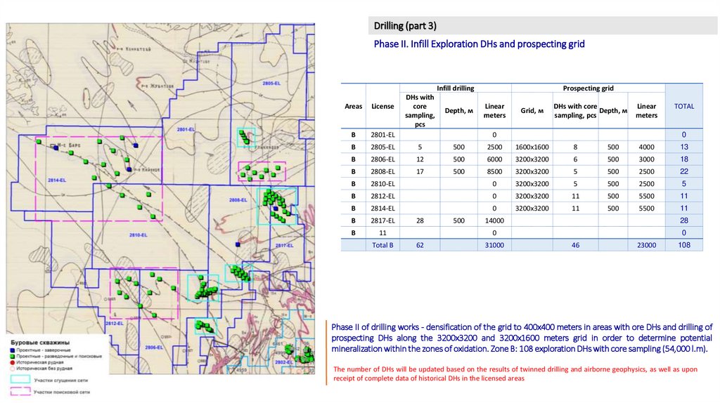
Drilling (part 3)Phase II. Infill Exploration DHs and prospecting grid
Infill drilling
DHs with
core
sampling,
pcs
Prospecting grid
Areas
License
В
2801-EL
В
2805-EL
5
500
2500
1600х1600
8
500
4000
13
В
2806-EL
12
500
6000
3200х3200
6
500
3000
18
В
2808-EL
17
500
8500
3200х3200
5
500
2500
22
В
2810-EL
0
3200х3200
5
500
2500
5
В
2812-EL
0
3200х3200
11
500
5500
11
В
2814-EL
0
3200х3200
11
500
5500
11
В
2817-EL
В
11
Total В
Depth, м
Linear
meters
Grid, м
DHs with core
Depth, м
sampling, pcs
Linear
meters
0
28
62
500
TOTAL
0
14000
28
0
0
31000
46
23000
108
Phase II of drilling works - densification of the grid to 400x400 meters in areas with ore DHs and drilling of
prospecting DHs along the 3200x3200 and 3200x1600 meters grid in order to determine potential
mineralization within the zones of oxidation. Zone B: 108 exploration DHs with core sampling (54,000 l.m).
The number of DHs will be updated based on the results of twinned drilling and airborne geophysics, as well as upon
receipt of complete data of historical DHs in the licensed areas
19.
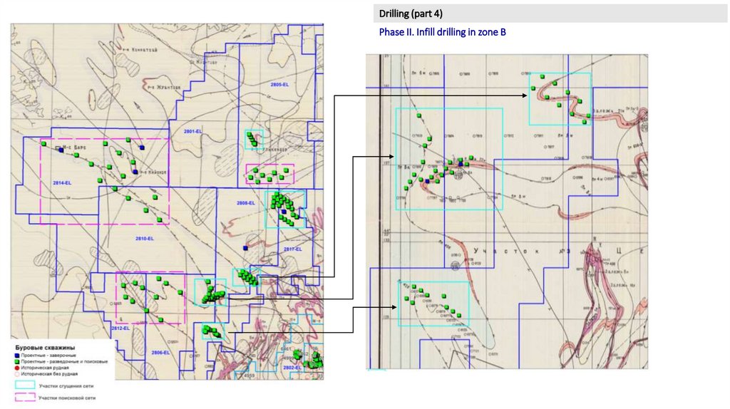
Drilling (part 4)Phase II. Infill drilling in zone B
20.
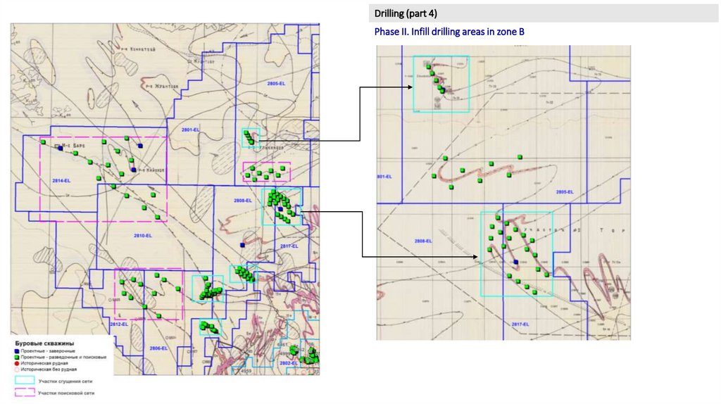
Drilling (part 4)Phase II. Infill drilling areas in zone B
21.
SummaryTwinned drilling
Infill drilling
Core sampling DHs with core
intervals
sampling, pcs
Prospecting grid
Areas
License
DHs with core
sampling, pcs
Depth, m
Per linear
meter
А
2802-EL
6
478
2880
А
2803-EL
0
0
А
2804-EL
0
0
А
2809-EL
2
490
980
455-475
19
500
9500
21
А
2816-EL
2
600
1200
580-600
6
600
3600
8
В
2801-EL
0
0
В
2805-EL
1
500
500
470-500
5
500
2500
1600х1600
8
500
4000
14
В
2806-EL
1
500
500
470-500
12
500
6000
3200х3200
6
500
3000
19
В
2808-EL
2
500
1000
470-500
17
500
8500
3200х3200
5
500
2500
24
В
2810-EL
0
0
3200х3200
5
500
2500
5
В
2812-EL
0
0
3200х3200
11
500
5500
11
В
2814-EL
2
500
1000
470-500
0
3200х3200
11
500
5500
13
В
В
2817-EL
11
Total А
Total В
Total А-В
1
500
500
0
5060
3500
8560
470-500
0
23000
23000
29
0
106
115
221
450-470
71
Depth, m
Per linear
meter
500
35500
0
10
7
17
28
96
62
158
500
grid, m
DHs with core
sampling, pcs
Depth, m
Per linear
meter
TOTAL
77
14000
0
48600
31000
79600
0
46
46
Drilling operations are designed to refine the orebody contours and determine potential mineralization within the zones of oxidation.
Zones A and B: 221 exploration DHs with core sampling (111 160 l.m.).
The number of DHs will be updated based on the results of twinned drilling and airborne geophysics, as well as upon receipt of complete data of historical DHs in the licensed areas
22.
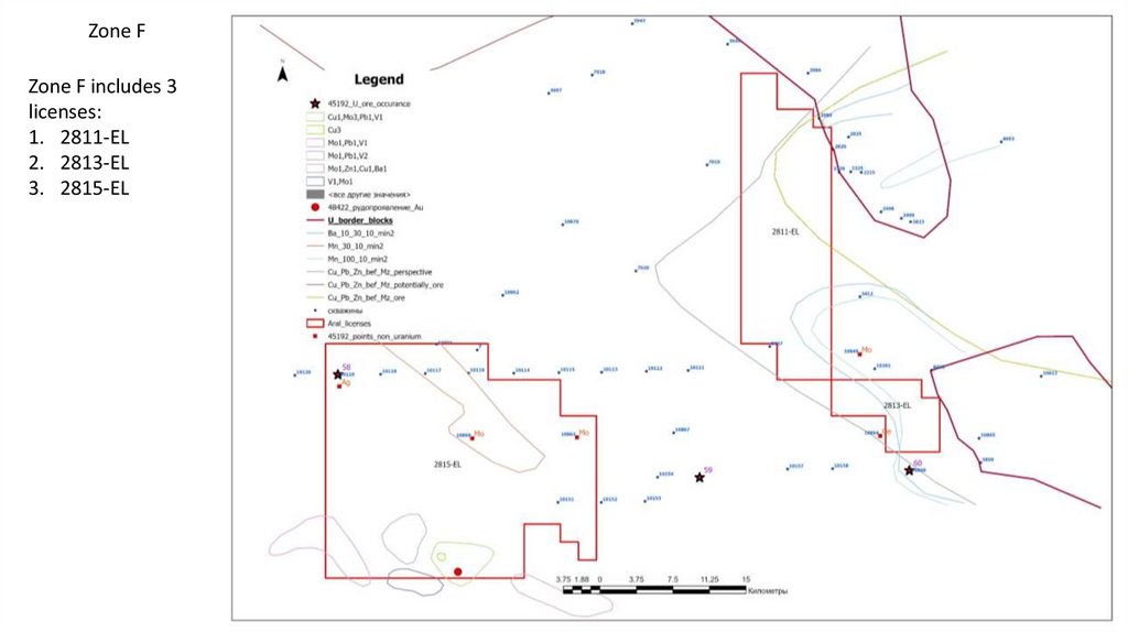
Zone F23.
Zone FZone F includes 3
licenses:
1. 2811-EL
2. 2813-EL
3. 2815-EL
24.
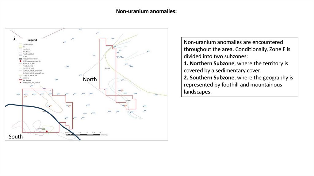
Non-uranium anomalies:North
South
Non-uranium anomalies are encountered
throughout the area. Conditionally, Zone F is
divided into two subzones:
1. Northern Subzone, where the territory is
covered by a sedimentary cover.
2. Southern Subzone, where the geography is
represented by foothill and mountainous
landscapes.
25.
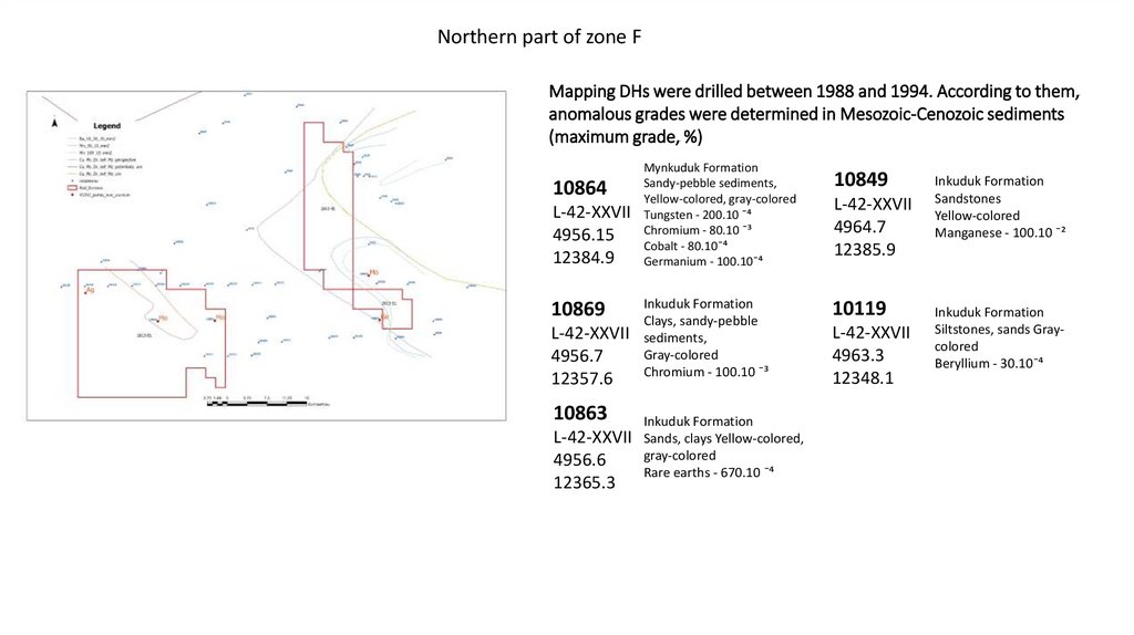
Northern part of zone FMapping DHs were drilled between 1988 and 1994. According to them,
anomalous grades were determined in Mesozoic-Cenozoic sediments
(maximum grade, %)
10864
L-42-XXVII
4956.15
12384.9
10869
L-42-XXVII
4956.7
12357.6
10863
Mynkuduk Formation
Sandy-pebble sediments,
Yellow-colored, gray-colored
Tungsten - 200.10 ¯⁴
Chromium - 80.10 ¯³
Cobalt - 80.10¯⁴
Germanium - 100.10¯⁴
Inkuduk Formation
Clays, sandy-pebble
sediments,
Gray-colored
Chromium - 100.10 ¯³
Inkuduk Formation
L-42-XXVII Sands, clays Yellow-colored,
gray-colored
4956.6
Rare earths - 670.10 ¯⁴
12365.3
10849
L-42-XXVII
4964.7
12385.9
10119
L-42-XXVII
4963.3
12348.1
Inkuduk Formation
Sandstones
Yellow-colored
Manganese - 100.10 ¯²
Inkuduk Formation
Siltstones, sands Graycolored
Beryllium - 30.10¯⁴
26.
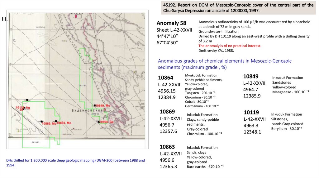
45192. Report on DGM of Mesozoic-Cenozoic cover of the central part of theChu-Sarysu Depression on a scale of 1200000, 1997.
III.
Anomaly 58
Sheet L-42-XXVII
44°47’10”
67°04’50”
Anomalous radioactivity of 106 µR/h was encountered by a borehole
at a depth of 72 m in gray sands.
Groundwater-infiltration.
Drilled by DH 10119 along an east-west profile with a drilling density
of 3.2 m
The anomaly is of no practical interest.
Dmitrovsky Y.V., 1988.
Anomalous grades of chemical elements in Mesozoic-Cenozoic
sediments (maximum grade , %)
10864
L-42-XXVII
4956.15
12384.9
10869
L-42-XXVII
4956.7
12357.6
10863
DHs drilled for 1:200,000 scale deep geologic mapping (DGM-200) between 1988 and
1994.
L-42-XXVII
4956.6
12365.3
Mynkuduk Formation
Sandy-pebble sediments,
Yellow-colored,
gray-colored
Tungsten - 200.10 ¯⁴
Chromium - 80.10 ¯³
Cobalt - 80.10¯⁴
Germanium - 100.10¯⁴
Inkuduk Formation
Clays, sandy-pebble
sediments,
Gray-colored
Chromium - 100.10 ¯³
Inkuduk Formation
Sands, clays
Yellow-colored,
gray-colored
Rare earths - 670.10 ¯⁴
10849
L-42-XXVII
4964.7
12385.9
10119
L-42-XXVII
4963.3
12348.1
Inkuduk Formation
Sandstones
Yellow-colored
Manganese - 100.10 ¯²
Inkuduk Formation
Siltstones,
sands Gray-colored
Beryllium - 30.10¯⁴
27.
Southern part of zone FCu-0.02%
There are 4 geochemical halos
identified within license 2815 :
1. Mo, Pb, V
2. Cu, Mo, Pb, V
3. V, Mo
4. Mo, Pb, V
The copper grade according to the results
of geochemical sampling exceeds 0.02%,
which is very promising.
Bapasai gold ore occurrence. The thickness is from 5 to 10
meters. Grades from 0.1 to 3.5, in some places up to 5 g/t.
The ore occurrence was discovered in 1980 within the
framework of prospecting works of Baibekov K.T., furrow
and rock-chip samples were taken. The authors recommend
to carry out exploration works at depth.
28.
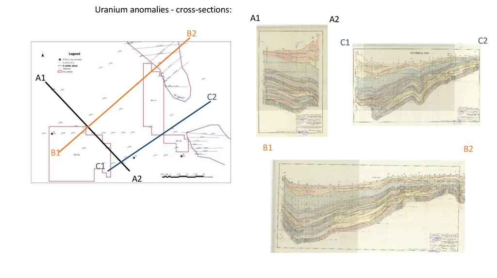
Uranium anomalies - cross-sections:A1
A2
B2
C2
C1
A1
C2
B1
B1
C1
A2
B2
29.
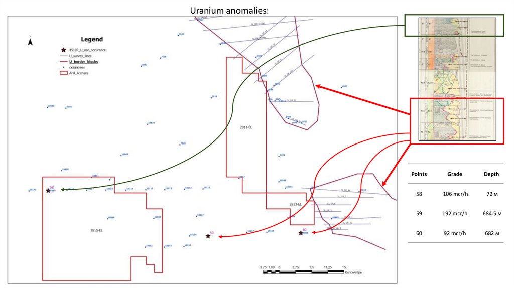
Uranium anomalies:Points
Grade
Depth
58
106 mcr/h
72 м
59
192 mcr/h
684.5 м
60
92 mcr/h
682 м
30.
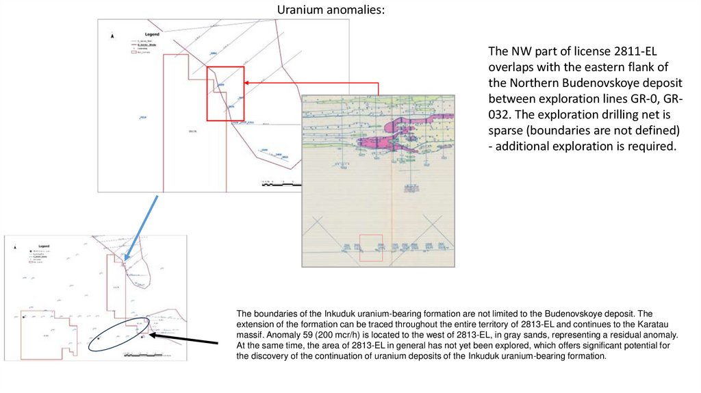
Uranium anomalies:The NW part of license 2811-EL
overlaps with the eastern flank of
the Northern Budenovskoye deposit
between exploration lines GR-0, GR032. The exploration drilling net is
sparse (boundaries are not defined)
- additional exploration is required.
The boundaries of the Inkuduk uranium-bearing formation are not limited to the Budenovskoye deposit. The
extension of the formation can be traced throughout the entire territory of 2813-EL and continues to the Karatau
massif. Anomaly 59 (200 mcr/h) is located to the west of 2813-EL, in gray sands, representing a residual anomaly.
At the same time, the area of 2813-EL in general has not yet been explored, which offers significant potential for
the discovery of the continuation of uranium deposits of the Inkuduk uranium-bearing formation.
31.
16715. Report of Expedition No. 7 under geological assignment 7-18 on the results ofprospecting works of 1:200000 meter scale within the northern flank of Budenovskoye uranium
deposit for the period 1987-1990.
II.
2811-EL: 2 km from the site - gray, barren DH 3412, depth 676 m (PR IV);
2811-EL: hole 2326 - gray, barren, depth 580 m. (PR III);
2811-EL: 600 m from the area of DH 2825 - gray, barren, depth 567 m. (PR
032);
2811-EL: 600 meters from the area of DH 360 - barren;
2811-EL:200 m from the area of DH 2094 - ore at depth 500 m, DH at
depth 511 m (PR 0); on the cross-section there is DH 2095 - ore,
the map does not show this DH
2813-EL: DH 3 - empty;
No parameters are shown on the available cross section, no other
materials are available
32.
Recommendations for Zone F licenses :1. Drill exploration DHs on the NW boundary of license 2811 to define the flank boundary of the Northern
Budenovskoye deposit.
2. Drill exploration DHs in the area of anomaly 58, as well as in the area between ore occurrences 59-60
and the Budenovskoye deposit.
3. Plan and conduct detailed geological exploration, including geochemical studies, trenching, and drilling,
in the Bapasay gold occurrence area.
4. Conduct a geochemical survey to confirm a copper (Cu) anomaly in the southern section of license 2815EL.
5. Request reports from the NGS on the results of modern exploration in the northern part of Area F (the
report we have is dated 2000).
6. To receive Ershov S.V.'s 1985 report based on geochemical studies in the southern part of License 2815EL.
33.
Potential Drilling Sites – Zone F34.
Drilling of twinned DHs (preliminary scope of work)Drilling of twinned DHs
Areas
License
DHs with core
sampling, pcs
F
F
2811-EL
2815-EL
Total F
2
2
17
Depth, м
Per linear meter
550
550
1100
1100
2200
Core sampling
interval
470-550
470-550
35.
Zone K36.
License: 3057-ELAccording to the results of earlier works, the West-Itmurun area (about 450 km2) in the western
part of the Itmurun stage may be of certain prospecting interest due to the boundary of the front
of the formation oxidation zone (FOZ) developing from the south (from the side of the preMesozoic formations of B.Karatau) in the middle Eocene Ikan horizon.
Area
Within the license area 3057 (25) according to the used report (Petrov, 2002,
№47418 “Report on deep geological mapping of Mesozoic-Cenozoic cover of
the Chu-Sarysu depression on a scale of 1:200000 sheets L-42-XXII, XXVIII,
XXXII(124), XXXIII, XXXIV, K-42-III (5-B, 6-A,B,G), IV (7-8) for 1996-2001. 19962001) deposits, occurrences and mineralization points of minerals are absent
West Itmurun
Ore-bearing
horizon
Ikan
Area size,
км2
Length of orebearing strip,
км
Accepted
linear
productivity,
т/км.
Potential
uranium
resources,
т
resource
category
450
40
300
3600
Р2
37.
License: 3057-EL и 3058-ELThe following mineral occurrences are present near the license:
Placer gold
Gold (calcite-chlorite-gold)
Uranium (pitchblende) with vanadium, molybdenum (phosphorus, arsenic, silver, etc.)
Pitchblende-coffinite uranium
38.
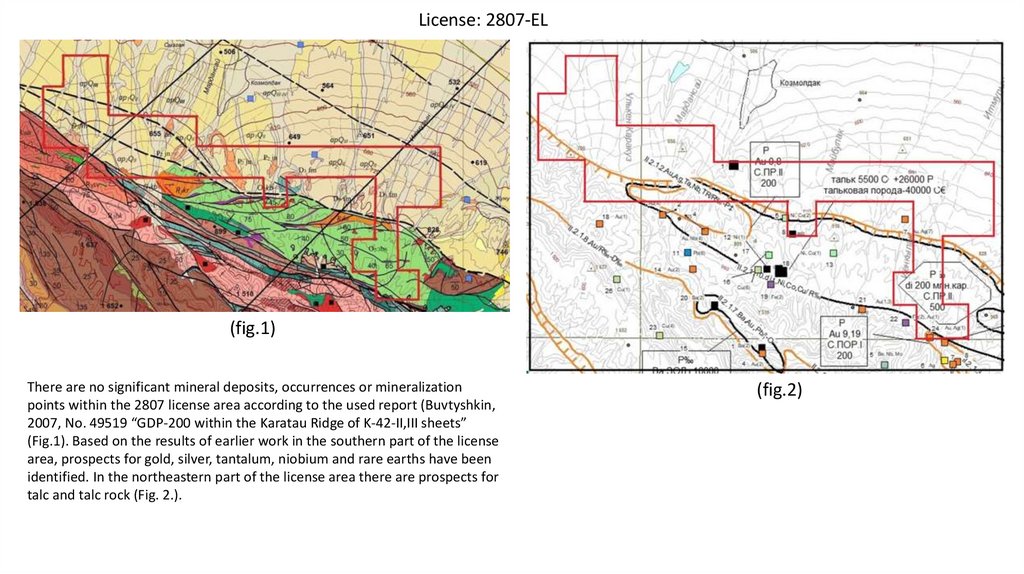
License: 2807-EL(fig.1)
There are no significant mineral deposits, occurrences or mineralization
points within the 2807 license area according to the used report (Buvtyshkin,
2007, No. 49519 “GDP-200 within the Karatau Ridge of K-42-II,III sheets”
(Fig.1). Based on the results of earlier work in the southern part of the license
area, prospects for gold, silver, tantalum, niobium and rare earths have been
identified. In the northeastern part of the license area there are prospects for
talc and talc rock (Fig. 2.).
(fig.2)
39.
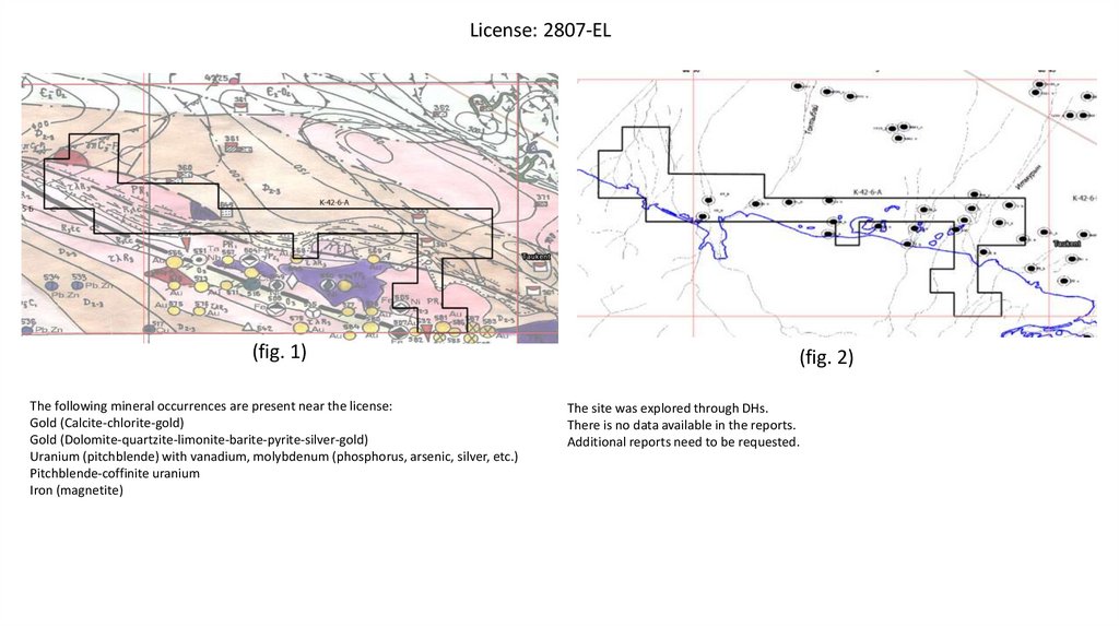
License: 2807-EL(fig. 1)
The following mineral occurrences are present near the license:
Gold (Calcite-chlorite-gold)
Gold (Dolomite-quartzite-limonite-barite-pyrite-silver-gold)
Uranium (pitchblende) with vanadium, molybdenum (phosphorus, arsenic, silver, etc.)
Pitchblende-coffinite uranium
Iron (magnetite)
(fig. 2)
The site was explored through DHs.
There is no data available in the reports.
Additional reports need to be requested.
40.
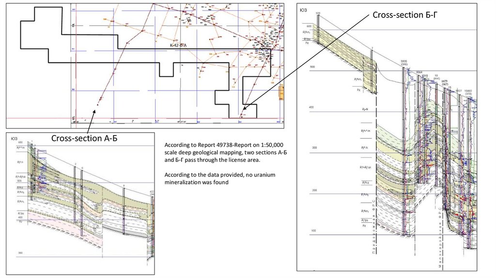
Cross-section Б-ГCross-section А-Б
According to Report 49738-Report on 1:50,000
scale deep geological mapping, two sections А-Б
and Б-Г pass through the license area.
According to the data provided, no uranium
mineralization was found
41.
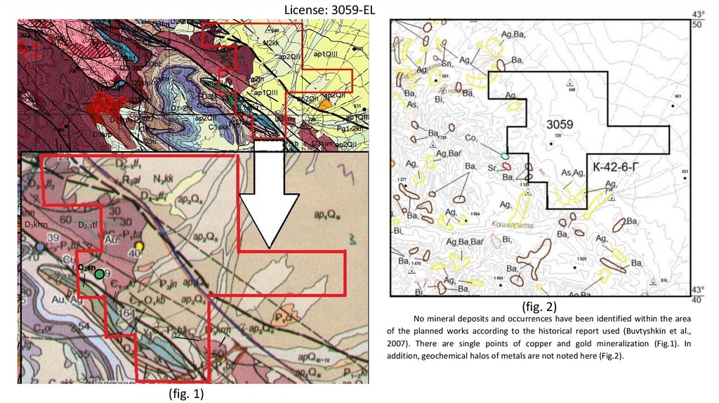
License: 3059-EL(fig. 2)
No mineral deposits and occurrences have been identified within the area
of the planned works according to the historical report used (Buvtyshkin et al.,
2007). There are single points of copper and gold mineralization (Fig.1). In
addition, geochemical halos of metals are not noted here (Fig.2).
(fig. 1)
42.
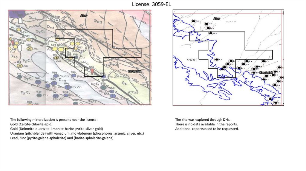
License: 3059-ELThe following mineralization is present near the license:
Gold (Calcite-chlorite-gold)
Gold (Dolomite-quartzite-limonite-barite-pyrite-silver-gold)
Uranium (pitchblende) with vanadium, molybdenum (phosphorus, arsenic, silver, etc.)
Lead, Zinc (pyrite-galena-sphalerite) and (barite-sphalerite-galena)
The site was explored through DHs.
There is no data available in the reports.
Additional reports need to be requested.
43.
License: 3052-ELNo mineral deposits and occurrences have been identified within the area of the planned works according to the used
historical report (Buvtyshkin et al., 2008).
44.
Recommendations for Area K licenses:1. No detailed information was found in the acquired historical reports to supplement the Exploration Plans
(Category 2 or 3) with drilling, trenches, and other methods. Additional historical reports are required.
2. Conduct geochemical works and airborne geophysics.
3. Plan core drilling based on the results of geochemical and airborne geophysics.
45.
Appendix 1Table of ore occurrences
46.
47418. Report on deep geological mapping of the Mesozoic-Cenozoic cover of the Chu-SarysuDepression on a scale of 1:200000 sheets L-42-XXII, XXVIII, XXXII(124), XXXIII, XXXIV, K-42-III (5-cБ, 6-A,Б,Г), IV (7-8) for 1996-2001.
From CATALOG of uranium deposits, ore occurrences and appearances (1)
Name of deposit, occurrence (ore
occurrences, r/a).Tablet
nomenclature, coordinates
Structural and
geological
position
Facies-lithological, geochemical
characteristics of ore-bearing
horizon (strata)
Geological and mineralogical and geochemical
characterization of the site and its main parameters
Genesis of
mineralization
State of study
Object Perspectives
Note, including source of
information
Bars deposit.
L-42-XXXIII(126-А)
44037'10" N.
68031'05" E.
Northeastern side Quaternary floodplain-channel
of the Suzak
sediments.
depression
The ore field is about 30 km long and 3-5 km wide. Conditional Exodiagenetic soiluranium mineralization occupies an area of about 6 square
infiltration.
kilometers. In general, the uranium grade of the deposit is
from 0.03% to 0.35%; thickness from 0.1 to 0.9 m. The depth is
10-22 meters; the bulk of uranium is concentrated in coaly
clays, clayey sands with abundant coaly detritus, as well as in
coaly interlayers. The ores are carbonate-silicate (silica grade 40-50%, carbonates - 15-20%, pyrite - up to 3-7%. Uranium
mineralization is dispersed, occasionally “sprinkles” of uranium
oxides (?) on pyrite crystals are observed, satellite elements (in
%): Mo (0.01-0.02); Rv(0.02-0.06); Ni; Co (0.001-0.005), and Ti
(0.05-0.5); Cr (0.002-0.1); Ba and Sr (0.02-1.0).
Detected in 1961.
A shallow deposit with Domaev E.S., Polomoshnov
Suzak PSP of the
average uranium grade in A.D. et al. Report of Suzak
South Caucasus State ores - 0.084% at an
party No. 37 on the works
University.Evaluated average thickness of 0.47 of 1962.Domaev E.S. et al.
in 1962-63 by batch meters. Possible mining Report of Suzak party № 37
No. 37 of the Volkov by heap leaching.
on the works of
Expedition.
Currently of no practical 1963.Berikbolov B.R.,
interest.
Petrov N.N., Karelin V.G.
152 holes were
Handbook “Uranium
drilled with a volume
Deposits of Kazakhstan”,
of 5,343 meters.
1996.
Kiiskoe ore occurrence
L-42-XXXIII
(-126, -A)
44034'00" N.
68041'50" E.
The
northwestern
part of the
OzhiraiTyubinskiy
cape in the
Baikadam
depression.
Interval with increased radioactivity from 150 to 2016
mcr/hr against a background of 12 mcr/hr in holes Nos. 17c,
2an, 17an at a depth of 400-420 m.
Uranium grade - 0.003-0.22%; radium (in uranium
equivalent) - 0.015-0.187%; thickness of ore intervals - from
1 to 4.7 meters.
Poor uranium mineralization was discovered in wells 11an
and 17c at depths of 310-320 meters.
It was revealed in
1972. SouthKazakhstan
hydrogeological
expedition of
KazGGU. It was
evaluated by party
№ 5 of Volkovsk
expedition in 197276.
24 holes with a
total volume of
11060 l.m.
Continental sandy sediments.
Boundary of the regional
redox outcropping.
Epigenetic, formationinfiltration.
It has no industrial
significance. It is of
prospecting interest
for identification of
industrial
mineralization in the
Uvanassky and
Uyuksky horizons.
Chaikovskaya A.T.
Report on mass searches
of the Kazakh
hydrogeological
department for
1972.Fedyakov V.V.
Report on mass
prospecting KGSU for
1975.Grechkin G.S.
Report of the mass
search party for
1976.Fedyakov V.V.
Report on the results of
evaluation work on the
Kiyskaya anomaly in
1975-77.
47.
47418. Report on deep geological mapping of the Mesozoic-Cenozoic cover of the Chu-SarysuDepression on a scale of 1:200000 sheets L-42-XXII, XXVIII, XXXII(124), XXXIII, XXXIV, K-42-III (5-cБ, 6-A,Б,Г), IV (7-8) for 1996-2001.
From CATALOG of uranium deposits, ore occurrences and appearances (1)
Name of deposit, occurrence (ore
Facies-lithological, geochemical
Structural and geological
occurrences, r/a). Tablet
characteristics of ore-bearing
position
nomenclature, coordinates
horizon (strata)
Geological and mineralogical and geochemical
characterization of the site and its main
parameters
Ulkensor ore occurrence
L-42-XXXIII
(-126-Б)
44039'00" N.
69001'00" E.
Northwestern part of the
Baikadam depression,
Sarbas brachyanticline.
Tortkuduk structural
nose.
Coastal-marine sandy-clay
deposits.Boundary of the
formation oxidation zone
eclination.
It is represented by two ore deposits, the distance
between which is 2.6 km.
Ore deposit No. 1 is 1.4 m thick, with uranium grade of
0.024%. It is 50-60 m wide, about 2 km long and 280 m
deep.
Ore deposit No. 2, 3.5 km long and 50-400 m wide,
Uranium grade in water-wet rocks - from 0.01 to
0.162% at a thickness of 0.20-1.0 m. In the interval 295296.8 m. Uranium grade is 0.016% at 1.8 m.
Peschanoye-I ore occurrence
L-42-XXXIV
(-127-В)
44012'01" N.
69008'03" E.
Northwestern part of the
Baikadam depression,
Ozhirai-Tyubinsky cape,
southeastern slope of the
Musabai brachianticline.
Coastal-marine sandy-clayey
sediments at the redox outcrop
boundary, in the rear of the
regional front at the boundary
with the “remnant” of graycolored rocks.
Peschanoye-II ore occurrence
L-42-XXXIV
(-127-В)
44013'05" N.
69007'04" E.
Northwestern part of the
Baikadam depression, on
the Ozhirai-Tyubinsk
cape, on the
southeastern slope of the
Musabai brachianticline,
2 km north of the
Peschanoye-I ore
occurrence.
Coastal-marine sandy-clayey
sediments; controlled by the
redox wedging boundary at the
rear of the regional front at the
boundary with the “remnant” of
gray-colored rocks.
Genesis of
mineralization
Note, including source of
information
State of study
Object Perspectives
Epigenetic,
formationinfiltration.
It was discovered in 1978
by batch No. 5 of EPGO.
Estimated by drilling
(10320 p.m.).
Due to insignificant
parameters, discontinuity
of mineralization is
unpromising in industrial
terms. The area may be of
some prospecting interest
for industrial ore bodies.
Aubakirov H.B. et al. Report on
geologic results of party No. 5 of
EPGO for the period of work 197578. Aubakirov H.B. et al. Report on
preliminary exploration of the
Moinkum deposit.
Two ore deposits were identified.
The upper ore body is confined to a remnant of graycolored sands (1.6x0.2 km) at the rear of the regional
front of the redox. The uranium grade is 0.042-0.131%;
the thickness of ore bodies is 1.1-8.4 m, and the depth
of occurrence is 452-470 meters. Uranium
mineralization is represented by coffinite and niello.
The lower deposit is confined to gray-colored finegrained quartz-mica sand with significant (10-15%)
grade of charred plant detritus. The uranium grade is
up to 0.094%; the thickness of ore bodies is up to 5.4 m,
and the depth of occurrence is 514-580m. Uranium
mineralization is represented by coffinite and
collomorphic nasturan.
Epigenetic,
formationinfiltration.
It was discovered by the
Dzhambul hydrogeological
expedition together with
party No. 41 of the
Volkovskaya expedition in
1971. The assessment was
carried out by drilling
through the net 1600200x800-100 m. (18526,9
l.m.).
Due to small parameters
the upper ore body is not
of industrial interest, the
lower ore body is not
estimated. It is of
prospecting interest to
identify commercial
mineralization in the area
of the ore occurrence.
Aubakirov H.B. Report on the results
of prospecting and exploration
works of Chulak-Kurgan party № 5
of the Volkovo expedition in the
area of the Kanzhugan deposit,
1974.Aubakirov H.B. Report on the
geological results of the party № 5
of the Volkovskaya Expedition for
the period of work 1975-78.
The thickness of the ore-bearing layer is 9-26 m. The
band of ore bodies is controlled by the redox boundary;
it is traced along the strike for 3 km, width about 400
m; depth of occurrence 440-500 m. Uranium
mineralization is represented by coffinite and nasturan.
Epigenetic,
formationinfiltration.
It was discovered by party
No. 5 of the Volkovskaya
expedition in 1972.
Estimated by drilling
through the 1600x800200m net.
The ore occurrence
requires additional
evaluation A promising
target for the
identification of industrial
mineralization in its area.
Aubakirov H.B. Report on the results
of prospecting and exploration
works of Chulak-Kurgan party № 5
of Volkovskaya expedition in the
area of Kanzhugan deposit,
1974.Kazakov I.S., Aubakirov H.B.
Report of Chulak-Kurgan party № 5
on the works of 1972-75.
48.
47418. Report on deep geological mapping of the Mesozoic-Cenozoic cover of the Chu-SarysuDepression on a scale of 1:200000 sheets L-42-XXII, XXVIII, XXXII(124), XXXIII, XXXIV, K-42-III (5-cБ, 6-A,Б,Г), IV (7-8) for 1996-2001.
№ on
the
map
501
714
719
720
Nomenclature according to
primary source.
Nomenclature of the tablet.
Geographical coordinates
Ozernoye structure
L-42-XXXIII
44038’ N.
68038’ E.
Hole.9.
Appearance
Mosque
L-42-XXVIII
44053'36" N.
69017'30" E.
Hole.65.
Appearance
Ojiraitobe
L-42-XXVIII
44043'40" N.
69004'30" E.
Hole 38.
Appearance Zhaldykum
L-42-XXVIII
44041'07" N.
69049'35" E.
Geological structure of the site
Northeastern side of the Suzak trough. An
accumulation of free hydrocarbon gas was found in
hole No. 5-g, in the depth interval 2016-2040 m in the
Turne-Visean sediments.
Geological and mineralogical and geochemical
characterization of the site
GAS
Gas composition: methane - 67%; ethane 2.8%; propane - 0.92%; heavy hydrocarbons trace.
Genesis
Sedimentarymetamorphosed
Yttrium-rare earth occurrences in Mesozoic-Cenozoic sediments
It is located in the central part of the Kyzymchek Stage At a depth of 101 meters in the mottled clay. Sedimentogenicand is confined to Upper Cretaceous-Lower Paleocene (К2km-P11 – Jalpak horizon) yttrium grade up to diagenetic
clays (К2km-P11).
0.01 and traces of ytterbium.
State of study
Perspectives
Note, including sources
of information
1 hole
No industrial
significance.
A.B.Lee. Tectonics and
prospects of oil and gas
bearing capacity of South
Kazakhstan “ Science”,
1975.
Metallometric
core sampling.
A search feature for rare
earth mineralization.
Komarnitsky B.E. Report
of the Kopkansor PSP
YUKGU on the works of
1961-62.
It is located in the southwestern part of the Mynchukur
stage of the Tastinsky Rise and is confined to coastalmarine sediments of the middle-upper Eocene age
(Р22-3).
At a depth of 57m in clayey quartz coastalmarine sands the grade of yttrium up to 0.05%;
ytterbium up to 0.002%.
Sedimentogenicdiagenetic
Metallometric
core sampling.
A search feature for rare
earth mineralization.
Komarnitsky B.E. Report
of the Kopkansor PSP
YUKGU on the works of
1961-62.
It is located in the southeastern part of the Kyzimchek
Stage of the Tastinsky Rise and is confined to
continental Upper Cretaceous-Lower Paleocene sandy
deposits (К2km-P11), as well as coastal-marine
sediments of the middle-upper Eocene (Р22-3).
At a depth of 38-40m in green marine clays
traces of yttrium and ytterbium. In the interval
of 100-120 m in quartz sands the grade of
yttrium from 0.003 to 0.01% and traces of
ytterbium.
Sedimentogenicdiagenetic
Metallometric
core sampling.
A search feature for rare
earth mineralization.
Komarnitsky B.E. Report
of the Kopkansor PSP
YUKGU on the works of
1961-62.
49.
ElementU
Anomaly number
location
Anomaly 58 Sheet L-42-XXVI 44gr. 47
min. 10 sec. N. 67g 04 min. 50 sec.
Southwestern side of the
Karakoin syncline
Anomaly 59 Sheet L-42-XXVI 40g 41
min. 30 sec. N. 67g 25 min. 00 sec.
geology
grade
Anomalous radioactivity of 106
Fine-grained sands in the
mcr/h was detected by a hole
lower parts of the Betpakdala
at a depth of 72 m. in gray
Formation P33-N11
sands
Fine-grained gray sands with Anomalous radioactivity of 192
Western side of the Kyzylkum small lenses and interlayers of mcr/h was detected by a hole
syncline
clays among sediments of the at a depth of 684.5 m in gray
Inkuduk Formation K2t2-st1
sands
Fine-grained gray sands with Anomalous radioactivity of 92
Anomaly 60 Sheet L-42-XXVI 44g 42 Submerged part of the western small lenses and interlayers of
mcr/h was detected by a
min. N. 67g 36 min. 30 sec.
side of the Suzak depression clays among sediments of the borehole at a depth of 682 m
Inkuduk Formation K2t2-st1
in gray sands
Au
Bapasai
Gold-sulfide-quartz,
Au 0.1 g/t (in ditches) 1.5, 3.2.5
hydrothermal.thickness 5-10
g/t in individual gizzard
m, length 1200 m.
samples.
composition
discovered by DHs
Source
Soil-infiltration
DH 1-119 in the latitudinal
density profile was opened.
Hole 3.2 km
-
Granito-infiltrative
DH 10155 was opened in the
latitudinal profile with a
density of 3.2 km. The hole is
3.2 km.
-
Granito-infiltrative
DH 10868 was opened in the
latitudinal profile with a
Aubakirov
density of 3.2 km. The hole is H.B. 1990.
3.2 km.
Search
works.
trenches, rock-chip sampling.
Baibekov
K.T. 1980.