Похожие презентации:
Coastal Hazards
1. Environmental Geology Chapter 9 - Coastal Hazards
9-12. The Coast
Coastal environment – setting whereterrestrial environment meets marine
environment
Coastlines (or shorelines) –
diverse animal life
commercial fisheries
port cities – commerce and trade, harbors
9-2
3.
4.
5.
9-6.
Hurricane Sandy in NYC9-6
7.
9-78. The Coast
Human development and consequences53% of U.S. population lives on a coast
which is 17% of our land
40% of world’s population lives within 100
km (62 mi) of a coast
This chapter discusses marine and
freshwater shorelines.
9-8
9. Shoreline Characteristics
Leading-edge ShorelineTectonically active; subduction zone
Rugged
U.S. Pacific coast
Trailing-edge Shoreline
Little to no tectonic activity
Straight, flat
U.S. Atlantic coast and Gulf area
Related to plate tectonics and sea level changes; currently
rising at 0.6 ft per 100 years
9-9
10.
9-1011. Shoreline Characteristics
Mass wasting more prevalent along leading edgeshoreline
Trailing edge can shift slowly over geologic time
Human development can disrupt natural
processes (Mississippi Delta and Venice)
Global climate change
Cooling increases glacial ice and lowers sea
level
Warming melts glacial ice and raises sea level
9-11
12. Coastal Processes
Ocean tides – periodic rise andfall of sea level.
Earth is spinning on same solar
plane as Moon and Sun. Net
outward force at equator.
Tidal Range
Spring Tide – max range
Neap Tide – small range
13. Coastal Processes
Currents – physical movement of water moleculesfrom one location to another; flow from high to low
energy
3 Types of Currents:
Tidal - high tide water forced into inlets and river
channels; reversed at low tide
Surface – in open water, wind blown and Earth’s
rotation, atmospheric pressure
Density – cold water more dense; saline water
more dense that fresh; “ocean conveyor,”
transfer heat energy and nutrients
9-13
14. Waves
Water waves transport energy horizontallyWater molecules vibrate in circular manner
causing objects to move vertically
Less frictional resistance than rocks
Water waves lose LESS energy as they
travel outward
9-14
15. Waves
9-1516. Waves
Wave base to measure wave energy9-16
17. Wave Refraction & Longshore Currents
Wave Refraction & Longshore CurrentsWave looses energy as base drags along sea floor
Wave refraction – as wave approaches shore, decrease
in velocity forces it to bend
9-17
18. Shoreline Evolution
Shoreline retreat – shoreline moveslandward due to erosion
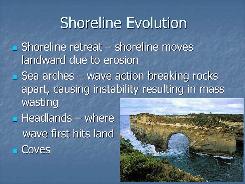
Sea arches – wave action breaking rocks
apart, causing instability resulting in mass
wasting
Headlands – where
wave first hits land
Coves
9-18
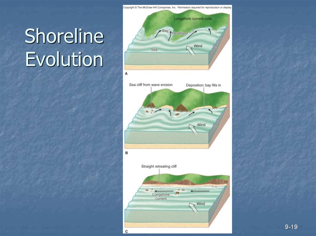
19. Shoreline Evolution
9-1920. Barrier Islands
21. Barrier Islands
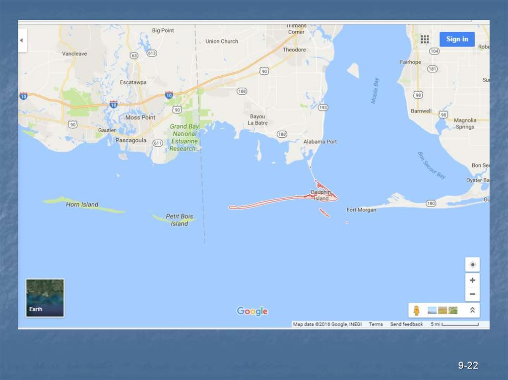
Separated from mainland by open water, lagoons, bay,marshes, tidal mudflats
9-21
22.
9-2223. Coastal Hazards & Mitigation
Coastal Hazards & MitigationHurricanes & ocean storms
Tropical Cyclone – large, rotating low-pressure,
tropical regions
Hurricane or typhoon – stronger, develop over warm
tropical oceans
Hurricanes form over warm tropical waters where
low pressure disturbance develops into large
rotating storm
High velocity winds (>150 mph is catastrophic)
Intense rainfall
Lasts several hours or more
9-23
24.
Figure 9.13, page 2709-24
25. Hurricanes
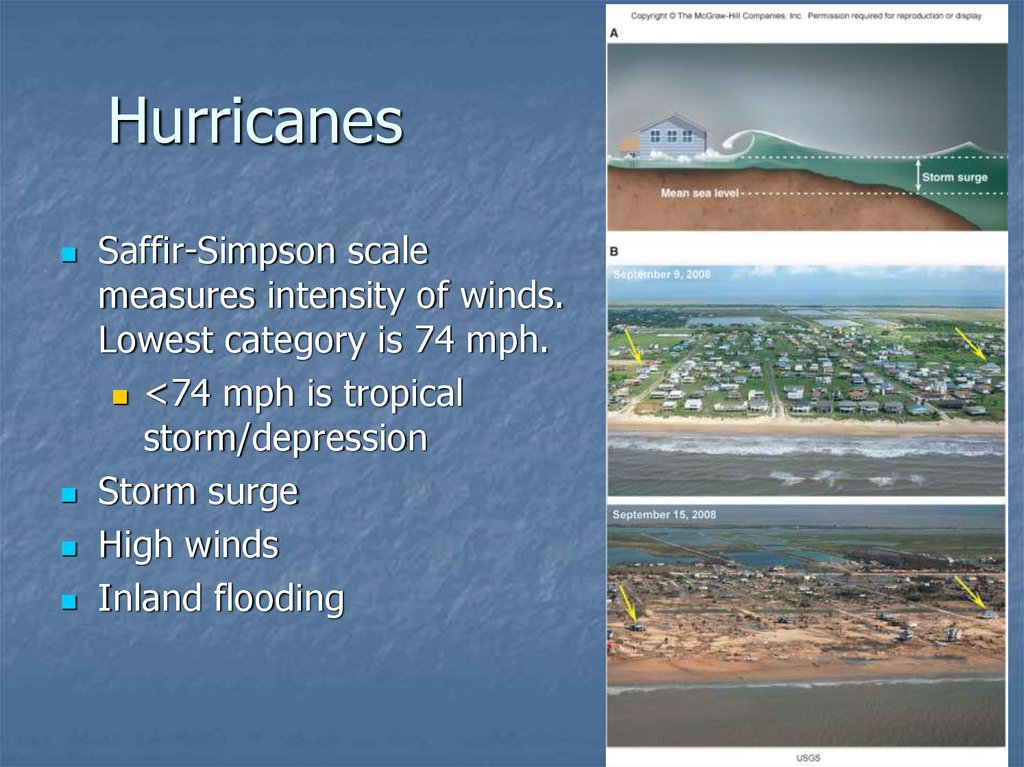
Saffir-Simpson scalemeasures intensity of winds.
Lowest category is 74 mph.
<74 mph is tropical
storm/depression
Storm surge
High winds
Inland flooding
9-25
26. Other Ocean Storms
Strong storms at higher lats (PacificNorthwest) when cold and warm air
masses collide along frontal boundaries
“northeasters” – on East coast cold arctic
air collides with warm humid air
associated w/ Gulf Stream – Hurricane
Sandy moved north and merged with cold
front
9-26
27. Mitigating Storm Hazards
Avoid building in areas of high % landfallSee Figure 9.20
Better forecasting and early warning
1900s ships radioed weather info
Post WWII, Air Force pilots recorded data
Now satellites, aircraft, computer models
Good emergency planning
Evacuations
See page 276 paragraph about New Orleans
Construction and building design strategies
9-27
28. Coastal Hazards and Tsunamis
Unusually high energy wavesForm from transfer of energy from
earthquakes, landslide, meteor impact
Interaction with sea floor makes them
dangerous closer to shore
“run up” – waves break pushing water far
above surf zone; can be >100 feet
9-28
29. Tsunamis
9-2930. Rip Currents
9-3031. Shoreline Retreat
Increased frequency of storms accelerateserosion
Effects of sea-level rise
See Figure 9.29 – Southern U.S.
Disruptions of sediment supply
Dredging – to make rivers deeper for ships
Artificial levees
Fig. 9.30 page 286
9-31
32. Mitigating Effects of Shoreline Processes
SeawallsGroins
Jetties
Breakwaters
Beach nourishment
Natural retreat
Fig. 9.32,
9-32
page 288
33. Mitigating Effects of Shoreline Processes
Seawalls – physical barrier (concrete, steel,wood, rocks) built along shore to protect real
estate or buildings. But, prevents deposition
and beach gets smaller due to erosion.
Groins – alternative to seawall, barrier is
perpendicular to shore and interrupts
longshore current so sand accumulates. But,
if groin is too long then long term erosion is a
problem.
9-33
34. Mitigating Effects of Shoreline Processes
Jetties – long barriers (up to a mile) of rocks,concrete or steel along an inlet to prohibit
deposition so that boats can travel into harbor.
But, prohibits deposition of sand down drift
(beach starvation). See Fig. 9.33, Page 288
Breakwaters – large linear structures placed
offshore to protect coast; helps beach grow.
But, prohibits deposition down drift, increases
shoreline retreat. See Fig 9.34, Page 289
9-34
35. Mitigating Effects of Shoreline Processes
Beach nourishment – most cost effective way(but can still be pricey depending on how
often it has to be done) to replenish sand,
pumping more sand from offshore deposits.
Widens beach, reduces erosion, improves
recreational use = tourism $$
Natural retreat – let nature take its course in
areas with small economic base and high
erosion rates
9-35









 География


