Похожие презентации:
Теория измерений. (Модуль 2)
1. Direction and Inclination Модуль 2 – Теория измерений Module 2 – Survey Theory
Module 2 – Survey TheoryD&M Learning Centers
Updated Mar 19th, 2008
Schlumberger Confidential
Direction and Inclination
Модуль 2 – Теория измерений
2. Задачи модуля Module Objectives
По окончании этого модуля инженер должен уметь:At the end of this module you should be able to
Перечислить и описать различные типы инклинометров
Объяснить основные преимущества гироскопических
инклинометров
Explain the major benefit of Gyro based survey measurements
Обозначить все элементы, определяющие точку замера
Describe all the elements that define a survey station
Описать как вычисляется зенитный угол скважины
Describe how we calculate the Inclination measurement
Описать как вычисляется азимут
Describe how we calculate the Azimuth measurement
Перечислите и опишите критерии качества замера
List and describe the Field Acceptance Criteria
Slide 2
D&M Learning Centers
Schlumberger Confidential
List and describe the different types of Survey Tools
3. Задачи модуля Module Objectives
По окончании этого модуля инженер должен уметь:At the end of this module you should be able to
List and describe the corrections applied to Inclination and Magnetic Azimuth and be able to calculate
them.
Описать различные методы вычисления замеров и
обозначить метод, применяемый в IDEAL/Maxwell
Explain different survey calculation methods and identify which survey calculation method is used by
IDEAL.
Объяснить точку привязки и каждый из результатов
вычисления замера
Describe a Tie In Point and all the outputs from the survey calculations
Объяснить, что такое эллипс неопределенности, и чем он
важен
Explain what an Ellipse of uncertainty is and why it is important
Slide 3
D&M Learning Centers
Schlumberger Confidential
Перечислить коррекции, которые применяются к
измерениям зенитного угла и магнитного азимута
4. Теория измерений Survey Theory
ИнклинометрыSurvey Tools
Slide 4
D&M Learning Centers
Schlumberger Confidential
1.
5. Типы инклинометров – индикаторы смещения Types of Surveying Tool -Inclination Only
Производят только замеры зенитного углаProvide borehole inclination only
Недорогой способ контроля вертикальности скважины
Существуют для применения как «во время бурения»,
так и «после бурения»
Available for “whilst drilling” & “after drilling”
TOTCO после бурения диск с пробитыми
метками
TOTCO after drilling punched card-board disc
AnderDrift во время бурения механическое
устройство, посылающее импульсы давления
AnderDrift whilst drilling mechanical device sending pressure pulses up hole
Не дают высокой точности – применяются только для
общей оценки
Not very accurate – give a general indication
Slide 5
D&M Learning Centers
Schlumberger Confidential
Used to monitor verticality of well bore – cheaply
6. Типы инклинометров - измеряющие угол и азимут Types of Surveying Tool - Inc & Az Tools
Типы инклинометров - измеряющие угол и азимутTypes of Surveying Tool - Inc & Az Tools
Магнитные приборы – измерение магнитного азимута
Magnetic Azimuth Tools
Измерение магнитного азимута
MN referenced
Single Shot
Измерения регистрируются на диске с фотопленкой или
электронным способом
Film disc or electronic
Многоточечные
Multi Shot
Измерения регистрируются на фотопленку или электронным
способом
Film strip or electronic
Телесистемы MWD – измерения в процессе бурения
MWD tools
Измерения производятся электронными компонентами
Electronic components
Slide 6
D&M Learning Centers
Schlumberger Confidential
Одноточечные
7. Типы инклинометров - измеряющие угол и азимут Types of Surveying Tool - Inc & Az Tools
Типы инклинометров - измеряющие угол и азимутTypes of Surveying Tool - Inc & Az Tools
Гироскопические
приборы
Gyroscopic Azimuth Tools
TN referenced
Свободные гироскопы
Free Gyro
Гироскопы угловой
скорости вращения
Земли
Earth Rate Gyro
Slide 7
D&M Learning Centers
Schlumberger Confidential
Измерение
географического азимута
8. Типы инклинометров - гироскопы Types of Surveying Tool – Gyroscopic Tools
Теория гироскопаGyro Theory
Balanced spinning mass
Масса свободно вращается
вокруг одной или
нескольких осей
Free to rotate on one or more axis
При этом противостоит
воздействию внешних сил
It is resistant to external forces
Не подвержена
воздействию магнитных сил
It has no magnetic effects
Slide 8
D&M Learning Centers
Schlumberger Confidential
Уравновешенная
вращающиеся масса
9. Типы инклинометров – гироскопические приборы Types of Surveying Tool - Gyroscopic Tools
Schlumberger ConfidentialSlide 9
D&M Learning Centers
10. Типы инклинометров - гироскопы Types of Surveying Tool – Gyroscopic Tools
Существуют два типа гироскоповTwo types of tools
Свободный гироскоп
Прибор ориентирован по определенному
направлению, измеряется отклонение от этого
направления, откорректированное по дрейфу
Tool aligned to a specific heading and variation from this heading, corrected for drift is measured
Гироскоп угловой скорости вращения Земли
Earth Rate Gyro
Азимут определяется с помощью измерения угловой
скорости вращения Земли
Speed of earths rotation measured and processed to a specific azimuth
Slide 10
D&M Learning Centers
Schlumberger Confidential
Free Gyro
11. Типы инклинометров – телесистемы MWD Types of Surveying Tool - MWD Tools
Не извлекаемые, смонтированные в УБТ компонентыNon-Retrievable Collar Mounted
Schlumberger Confidential
PowerPulse*
TeleScope*
IMPulse*
Компоненты извлекаемые
Retrievable Collar Mounted
SlimPulse*
E-Pulse
Downhole
flow rate
Direction and
inclination
Transmission
module
Downhole
weight and
torque on bit
Slide 11
D&M Learning Centers
Power generation
module
Electronics
module
Gamma ray or
3-axis vibration
12. Survey Theory
Что составляет замеринклинометрии, и каким
образом он берется?
What is a Survey and how do we take it?
Slide 12
D&M Learning Centers
Schlumberger Confidential
2.
13. Определение замера Survey Definition
A survey is simply three measurements made at a pointbelow the surface of the earth:
Глубина по стволу
скважины
Measured Depth
Зенитный угол
Inclination
Азимут
Azimuth
Slide 13
D&M Learning Centers
Schlumberger Confidential
Замер состоит из трех
измерений, сделанных в
одной точке:
14. Инклинометрия приборами MWD Measuring D&I with MWD tools
Инклинометрия приборами MWDMeasuring D&I with MWD tools
Прибор MWD измеряет зенитный угол ствола скважины
путем измерения направления гравитационного поля
Земли относительно прибора
Прибор MWD измеряет азимут ствола скважины путем
измерения направления магнитного поля Земли
относительно прибора
The MWD tool measures the Azimuth of the well bore by measuring the direction of the earth’s Magnetic Field
relative to the tool.
Измерение глубины по стволу выполняется датчиками
наземной системы
The depth measurement comes from our surface sensors
Slide 14
D&M Learning Centers
Schlumberger Confidential
The MWD tool measures the Inclination of the well bore by measuring the direction of the earths Gravitational Field
relative to the tool.
15. Базовая терминология Basic Nomenclature
Нашей целью является измерение следующих физическихсвойств Земли:
H – вектор магнитного поля (в гаммах)
H = Total Magnetic Field Strength (gammas)
G – вектор гравитационного поля
G = Total Gravity Field Strength
Параметры, фактически вычисляемые в IDEAL/Maxwell
What we actually Calculate inside IDEAL:
Tool H = вычисляемый магнитный вектор (counts)
Tool H = What we calculate for the Magnetic Vector (counts)
Tool G = вычисляемый гравитационный вектор
Tool G = What we calculate for the Gravity Vector
Slide 15
D&M Learning Centers
Schlumberger Confidential
The Earths properties that we are trying to measure:
16. Зенитный угол – вектор гравитационного поля Inclination - Gravity Field Vector
The inclination at a point along the well bore is ameasurement of the angle of deviation from vector
g
Вектор g направлен к центру
Земли
Vector g points towards the center of the Earth
Единица измерения –
«counts», 1000 counts = 1g
Units of measurement are “counts”, 1000 “count” =
1g
Slide 16
D&M Learning Centers
Schlumberger Confidential
Зенитным углом в данной
точке ствола скважины
называется угол отклонения
ствола от вектора g
17. Зенитный угол – вектор гравитации Inclination – Gravity Field Vector
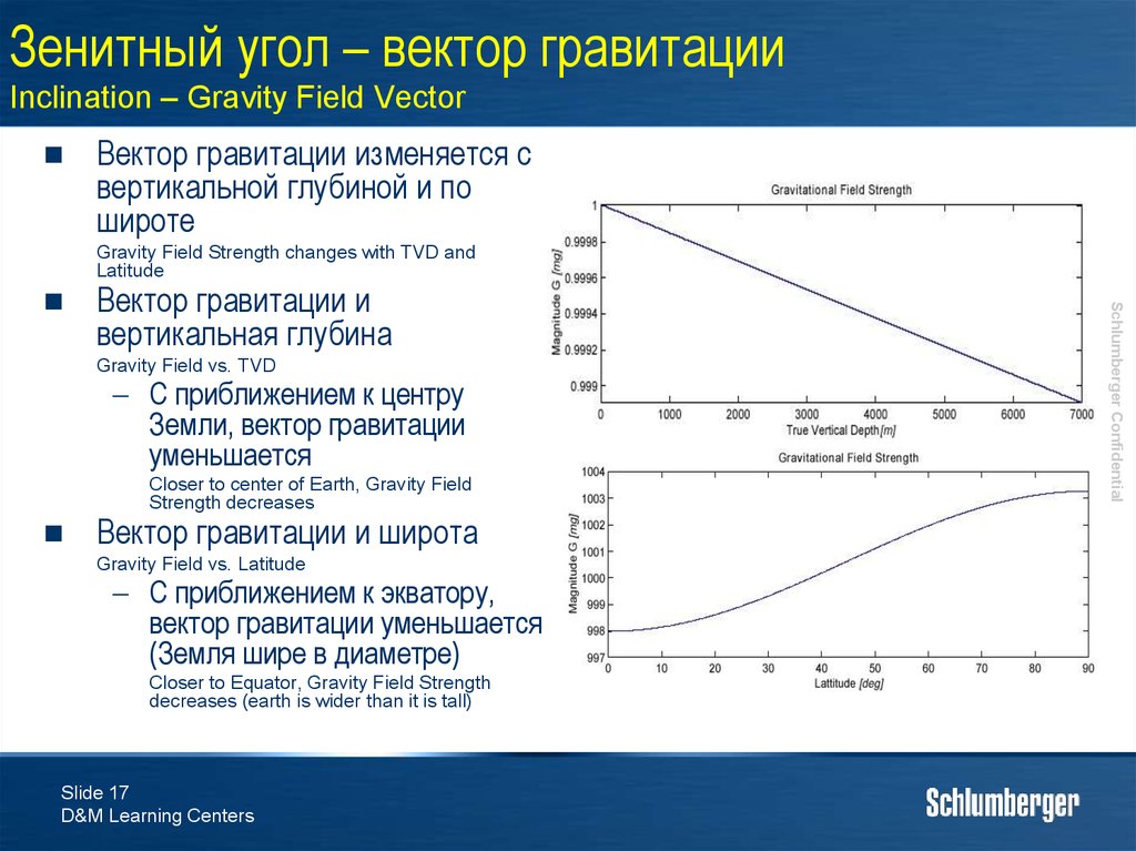
Вектор гравитации изменяется свертикальной глубиной и по
широте
Gravity Field Strength changes with TVD and
Latitude
Вектор гравитации и
вертикальная глубина
Gravity Field vs. TVD
С приближением к центру
Земли, вектор гравитации
уменьшается
Closer to center of Earth, Gravity Field
Strength decreases
Вектор гравитации и широта
Gravity Field vs. Latitude
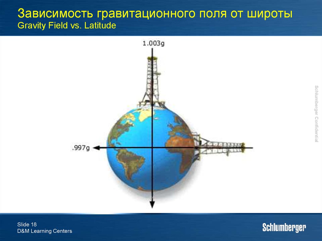
С приближением к экватору,
вектор гравитации уменьшается
(Земля шире в диаметре)
Closer to Equator, Gravity Field Strength
decreases (earth is wider than it is tall)
Slide 17
D&M Learning Centers
Schlumberger Confidential
18. Зависимость гравитационного поля от широты Gravity Field vs. Latitude
Schlumberger ConfidentialSlide 18
D&M Learning Centers
19. Зенитный угол – приборы MWD - акселерометры Inclination - MWD Tools - Accelerometers
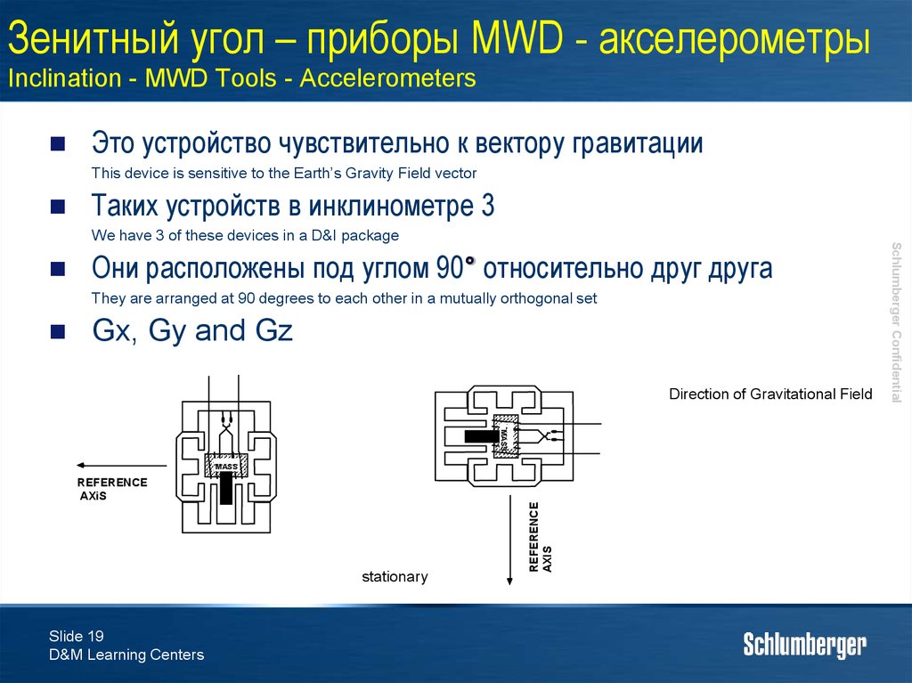
Это устройство чувствительно к вектору гравитацииThis device is sensitive to the Earth’s Gravity Field vector
Таких устройств в инклинометре 3
Они расположены под углом 90° относительно друг друга
They are arranged at 90 degrees to each other in a mutually orthogonal set
Gx, Gy and Gz
Direction of Gravitational Field
MASS
stationary
Slide 19
D&M Learning Centers
= 1G
=0G
REFERENCE
AXIS
MASS
REFERENCE
AXiS
Schlumberger Confidential
We have 3 of these devices in a D&I package
20. Зенитный угол – трехосные акселерометры Inclination - Tri-Axial Accelerometers
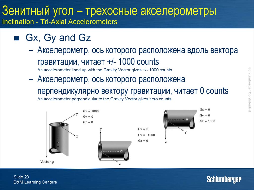
Gx, Gy and Gz– Акселерометр, ось которого расположена вдоль вектора
гравитации, читает +/- 1000 counts
– Акселерометр, ось которого расположена
перпендикулярно вектору гравитации, читает 0 counts
An accelerometer perpendicular to the Gravity Vector gives zero counts
Slide 20
D&M Learning Centers
Schlumberger Confidential
An accelerometer lined up with the Gravity Vector gives +/- 1000 counts
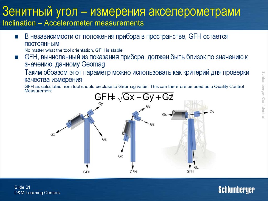
21. Зенитный угол – измерения акселерометрами Inclination – Accelerometer measurements
В независимости от положения прибора в пространстве, GFH остаетсяпостоянным
No matter what the tool orientation, GFH is stable
GFH as calculated from tool should be close to Geomag value. This can therefore be used as a Quality Control
Measurement
GFH Gx Gy Gz
2
Slide 21
D&M Learning Centers
2
2
Schlumberger Confidential
GFH, вычисленный из показания прибора, должен быть близок по значению к
значению, данному Geomag
Таким образом этот параметр можно использовать как критерий для проверки
качества измерения
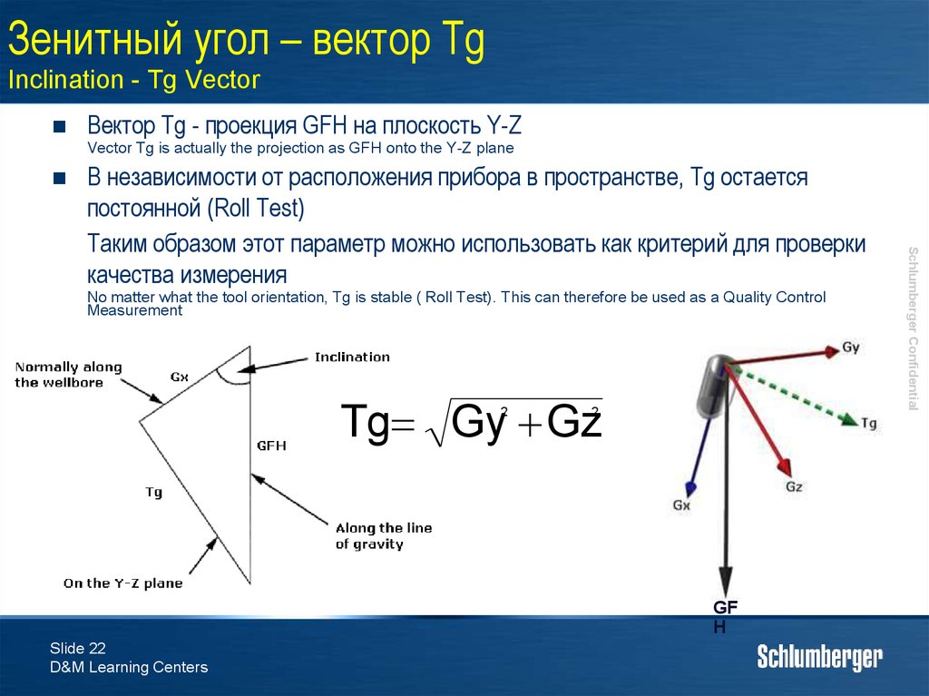
22. Зенитный угол – вектор Tg Inclination - Tg Vector
Вектор Tg - проекция GFH на плоскость Y-ZVector Tg is actually the projection as GFH onto the Y-Z plane
No matter what the tool orientation, Tg is stable ( Roll Test). This can therefore be used as a Quality Control
Measurement
Tg Gy Gz
2
2
GF
H
Slide 22
D&M Learning Centers
Schlumberger Confidential
В независимости от расположения прибора в пространстве, Tg остается
постоянной (Roll Test)
Таким образом этот параметр можно использовать как критерий для проверки
качества измерения
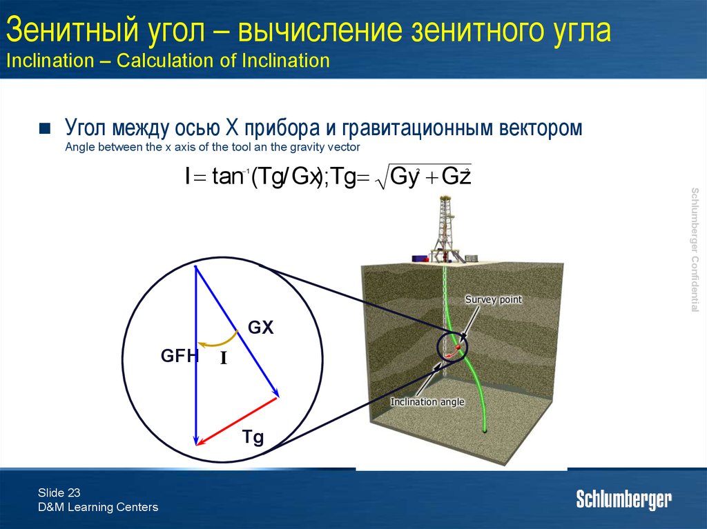
23. Зенитный угол – вычисление зенитного угла Inclination – Calculation of Inclination
Угол между осью X прибора и гравитационным векторомAngle between the x axis of the tool an the gravity vector
I tan (Tg/ Gx);Tg Gy Gz
1
GFH
I
Tg
Slide 23
D&M Learning Centers
2
Schlumberger Confidential
GX
2
24. Inclination - Practical
Calculate the value of Inclination from the databelow:
Gx = 765
Gy = 234
Gz = 600
Зенитный угол = ?
Inclination = ?
Slide 24
D&M Learning Centers
GX
GFH
I
Tg
Schlumberger Confidential
Вычислить значение
зенитного угла по данным
ниже
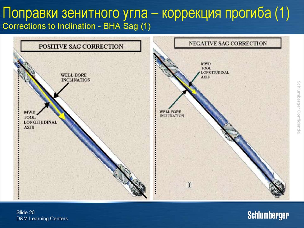
25. Поправки зенитного угла – коррекция прогиба (1) Corrections to Inclination - BHA Sag (1)
The MWD tool generally does not lie exactly centralized in the bore hole – the main tool axis and the wellbore axis arenot parallel.
Под действием гравитации прибор может прогибаться
Due to gravity the tool will sink to the bottom of the borehole (sag).
При наличии стабилизаторов в КНБК, прибор находиться
под углом к оси скважины
Stabilizers in the BHA will put the MWD at an angle.
Необходимо уметь определять угол прогиба и применять
эту поправку к зенитному углу
Need to be able to quantify the amount of SAG and correct for it
Slide 25
D&M Learning Centers
Schlumberger Confidential
Прибор MWD редко бывает точно централизован в
стволе скважины – ось прибора не параллельна оси
скважины
26. Поправки зенитного угла – коррекция прогиба (1) Corrections to Inclination - BHA Sag (1)
Schlumberger ConfidentialSlide 26
D&M Learning Centers
27. Прогиб КНБК – вычисление вручную (1) BHA Sag - Manual Calculation (1)
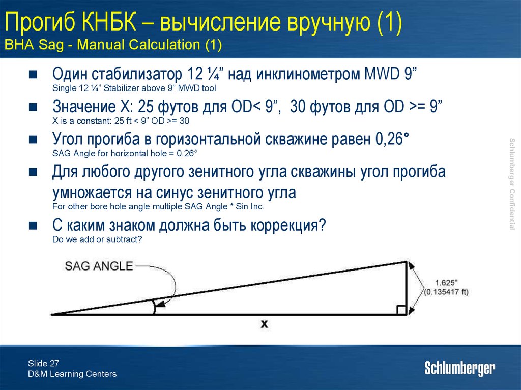
Один стабилизатор 12 ¼” над инклинометром MWD 9”Single 12 ¼” Stabilizer above 9” MWD tool
Значение X: 25 футов для OD< 9”, 30 футов для OD >= 9”
X is a constant: 25 ft < 9” OD >= 30
Угол прогиба в горизонтальной скважине равен 0,26°
SAG Angle for horizontal hole = 0.26°
Для любого другого зенитного угла скважины угол прогиба
умножается на синус зенитного угла
For other bore hole angle multiple SAG Angle * Sin Inc.
С каким знаком должна быть коррекция?
Do we add or subtract?
Slide 27
D&M Learning Centers
Schlumberger Confidential
28. Прогиб КНБК – вычисление вручную (2) BHA Sag - Manual Calculation (2)
Стабилизаторы по обоим концам инклинометраStabilized at both Ends
If stabilizer distance <40ft, treat as a rigid body
Если расстояние >40 футов (для OD<8”) или >60 футов
(для OD>8”), прогиб вычисляется как в случае с одним
стабилизатором, с тем к которому пакет датчиков ближе
If stabilizer distance is >40ft (<8” OD) or >60ft (>8” OD) then calculate as single stabilizer – whichever end the survey
package is nearest to
Если пакет датчиков находится на расстоянии не дальше
5 футов от центральной точки между двумя
стабилизаторами, прогиб игнорируется
If the survey package is within 5ft of the mid point b/w two stabilizers, then ignore
Slide 28
D&M Learning Centers
Schlumberger Confidential
Если расстояние между стабилизаторами меньше 12 м,
компоновка рассматривается как несгибаемая
29. Прогиб КНБК (3) BHA Sag (3)
С помощью программы DrillSafe, которая входит в пакетDrilling Office можно вычислить прогиб КНБК
Прогиб отсутствует в случае гладкой КНБК
Only time SAG is not present – slick assembly
Прогиб необходимо учитывать когда он > 0,1°
If SAG angle is >0.1° it should be taken into account
Slide 29
D&M Learning Centers
Schlumberger Confidential
DrillSafe, within the Drilling Office Suite of programs can calculate the BHA Sag
30. Азимут Azimuth
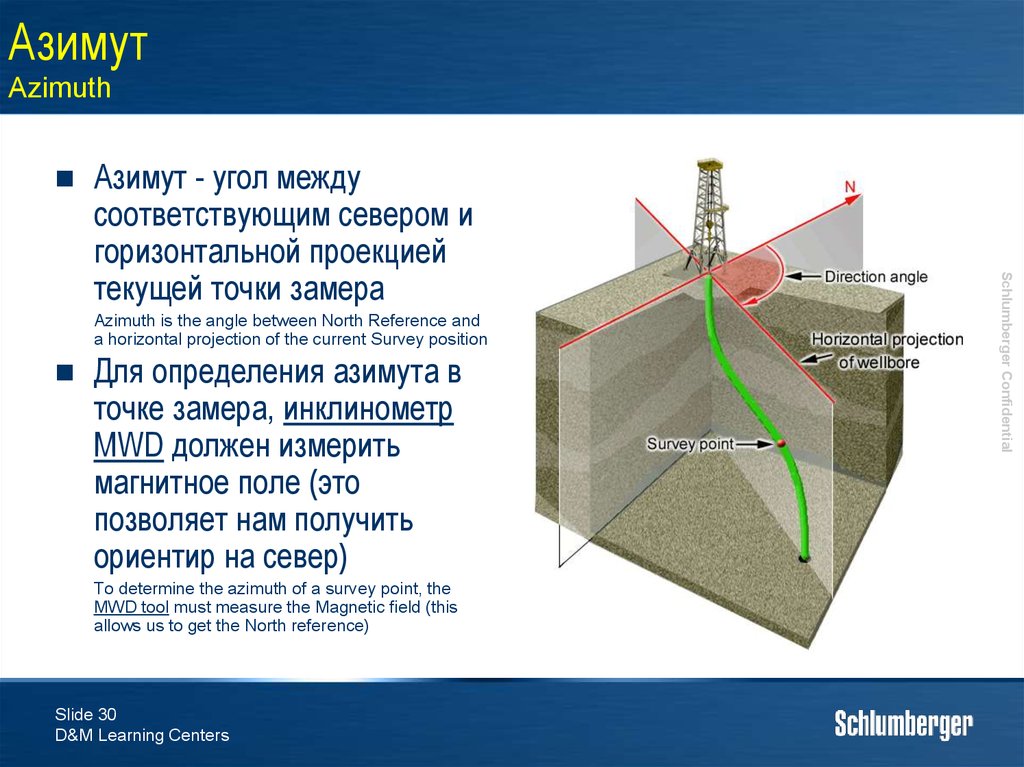
Azimuth is the angle between North Reference anda horizontal projection of the current Survey position
Для определения азимута в
точке замера, инклинометр
MWD должен измерить
магнитное поле (это
позволяет нам получить
ориентир на север)
To determine the azimuth of a survey point, the
MWD tool must measure the Magnetic field (this
allows us to get the North reference)
Slide 30
D&M Learning Centers
Schlumberger Confidential
Азимут - угол между
соответствующим севером и
горизонтальной проекцией
текущей точки замера
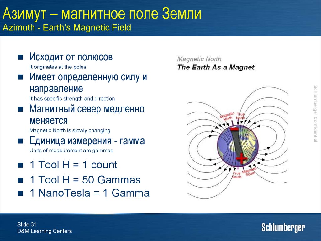
31. Азимут – магнитное поле Земли Azimuth - Earth’s Magnetic Field
Исходит от полюсовIt originates at the poles
It has specific strength and direction
Магнитный север медленно
меняется
Magnetic North is slowly changing
Единица измерения - гамма
Units of measurement are gammas
1 Tool H = 1 count
1 Tool H = 50 Gammas
1 NanoTesla = 1 Gamma
Slide 31
D&M Learning Centers
Schlumberger Confidential
Имеет определенную силу и
направление
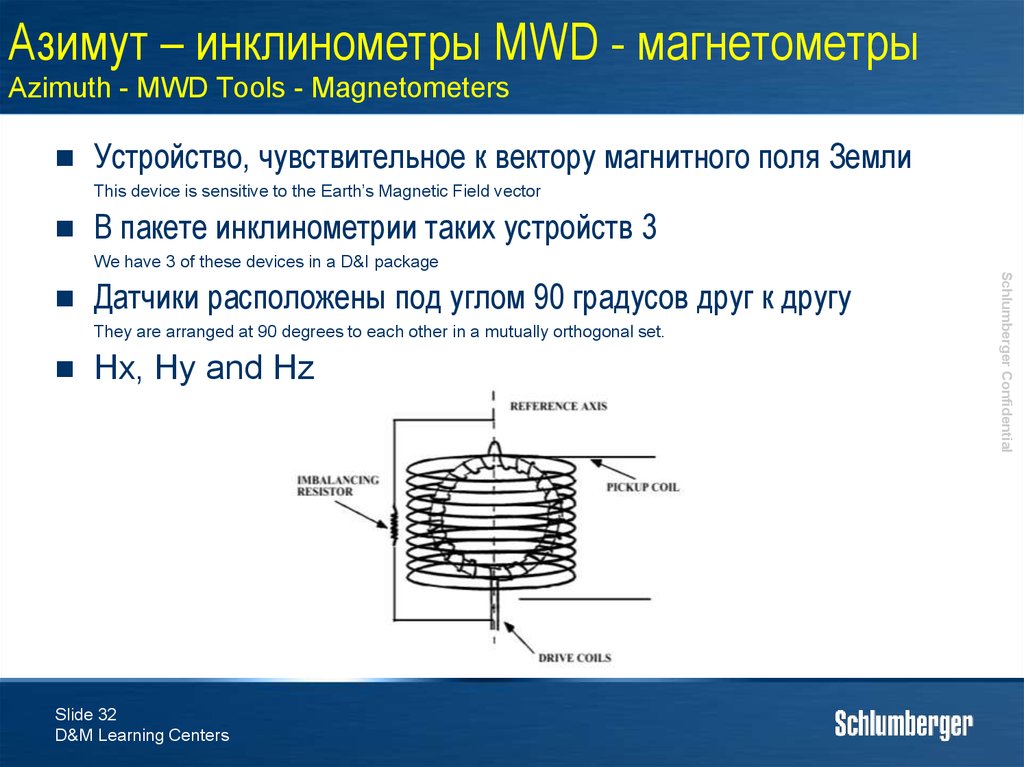
32. Азимут – инклинометры MWD - магнетометры Azimuth - MWD Tools - Magnetometers
Устройство, чувствительное к вектору магнитного поля ЗемлиThis device is sensitive to the Earth’s Magnetic Field vector
В пакете инклинометрии таких устройств 3
We have 3 of these devices in a D&I package
Датчики расположены под углом 90 градусов друг к другу
They are arranged at 90 degrees to each other in a mutually orthogonal set.
Hx, Hy and Hz
Slide 32
D&M Learning Centers
Schlumberger Confidential
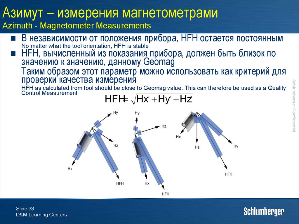
33. Азимут – измерения магнетометрами Azimuth - Magnetometer Measurements
В независимости от положения прибора, HFH остается постояннымNo matter what the tool orientation, HFH is stable
HFH as calculated from tool should be close to Geomag value. This can therefore be used as a Quality
Control Measurement
HFH Hx Hy Hz
2
Slide 33
D&M Learning Centers
2
2
Schlumberger Confidential
HFH, вычисленный из показания прибора, должен быть близок по
значению к значению, данному Geomag
Таким образом этот параметр можно использовать как критерий для
проверки качества измерения
34. Азимут – вектор Th Azimuth – Th Vector
Вектор Th - проекция HFH на плоскость Y-ZVector Th is actually the projection of HFH onto the y-z plane
No matter what the tool orientation Th is stable (Roll Test). During Roll Test it acts as a Quality Control
Measurement
Th Hy Hz
2
Slide 34
D&M Learning Centers
2
Schlumberger Confidential
В независимости от расположения прибора в пространстве, Th остается
постоянной (Roll Test)
Таким образом этот параметр можно использовать как критерий для проверки
качества измерения
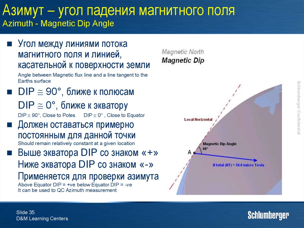
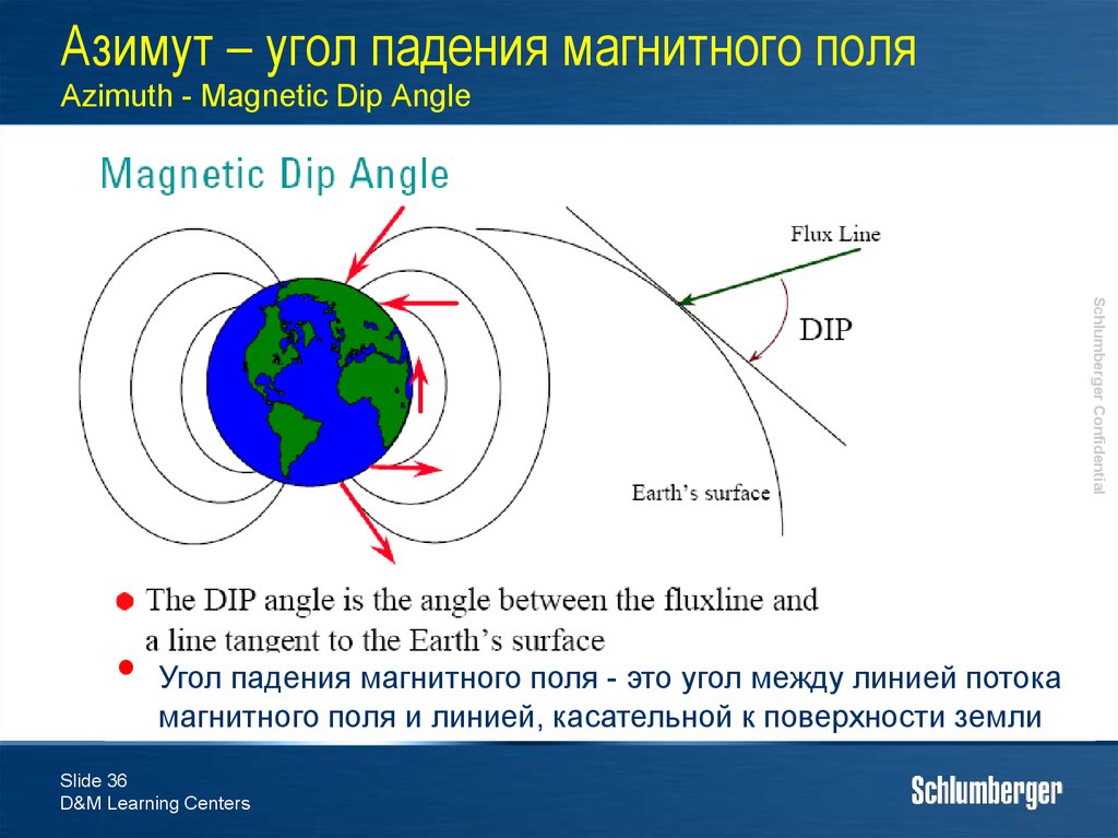
35. Азимут – угол падения магнитного поля Azimuth - Magnetic Dip Angle
Угол между линиями потокамагнитного поля и линией,
касательной к поверхности земли
DIP 90°, ближе к полюсам
DIP 0°, ближе к экватору
DIP 90°, Close to Poles
DIP 0° , Close to Equator
Должен оставаться примерно
постоянным для данной точки
Should remain relatively constant at a given location
Выше экватора DIP со знаком «+»
Ниже экватора DIP со знаком «-»
Применяется для проверки азимута
Above Equator DIP = +ve below Equator DIP = -ve
It can be used to QC Azimuth measurement
Slide 35
D&M Learning Centers
Schlumberger Confidential
Angle between Magnetic flux line and a line tangent to the
Earths surface
36. Азимут – угол падения магнитного поля Azimuth - Magnetic Dip Angle
Schlumberger ConfidentialУгол падения магнитного поля - это угол между линией потока
магнитного поля и линией, касательной к поверхности земли
Slide 36
D&M Learning Centers
37. Азимут – зачем нужны акселерометры Azimuth – need for accelerometers
Акселерометры также требуютсядля вычислений
We need accelerometers as well as magnetometers
If we simply measure from Survey Point to North – we get
an incorrect measurement (see length of blue arrow)
Точку замера нужно
спроектировать на
горизонтальную плоскость
We must project the Survey Point onto the Horizontal Plane
Акселерометры дают угол для
проекции на горизонтальную
плоскость
Accelerometers give us a reference to Horizontal
Slide 37
D&M Learning Centers
Schlumberger Confidential
Простое измерение угла между
точкой замера и севером неверно
(синяя стрелка на рисунке)
38. Поправки азимута Corrections to Azimuth
Азимут измеряется отмагнитного севера
Measured to Magnetic North
После (в большинстве
случаев) в IDEAL/Maxwell
делается поправка на
географический север в
зависимости от требований
заказчика
Then (in most cases) corrected in IDEAL to either
Geographic North or True North depending upon
what the client wants
Необходимо точно знать,
относительно какого
севера измеряется азимут!
Be sure you know what you are measuring and
referencing to!
Slide 38
D&M Learning Centers
Schlumberger Confidential
39. Поправки – карта угла падения BGGM Corrections - BGGM Magnetic Declination Map
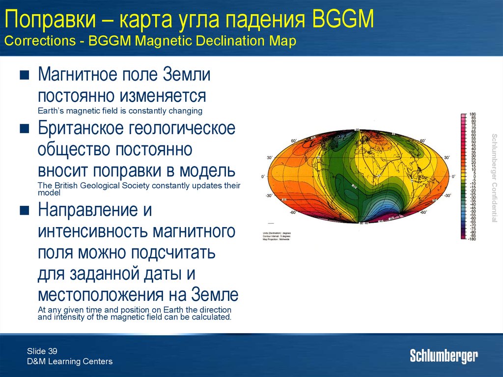
Магнитное поле Землипостоянно изменяется
Earth’s magnetic field is constantly changing
Британское геологическое
общество постоянно
вносит поправки в модель
The British Geological Society constantly updates their
model
Направление и
интенсивность магнитного
поля можно подсчитать
для заданной даты и
местоположения на Земле
At any given time and position on Earth the direction
and intensity of the magnetic field can be calculated.
Slide 39
D&M Learning Centers
Schlumberger Confidential
40. Поправки – обновления модели BGGM Corrections - BGGM Updates
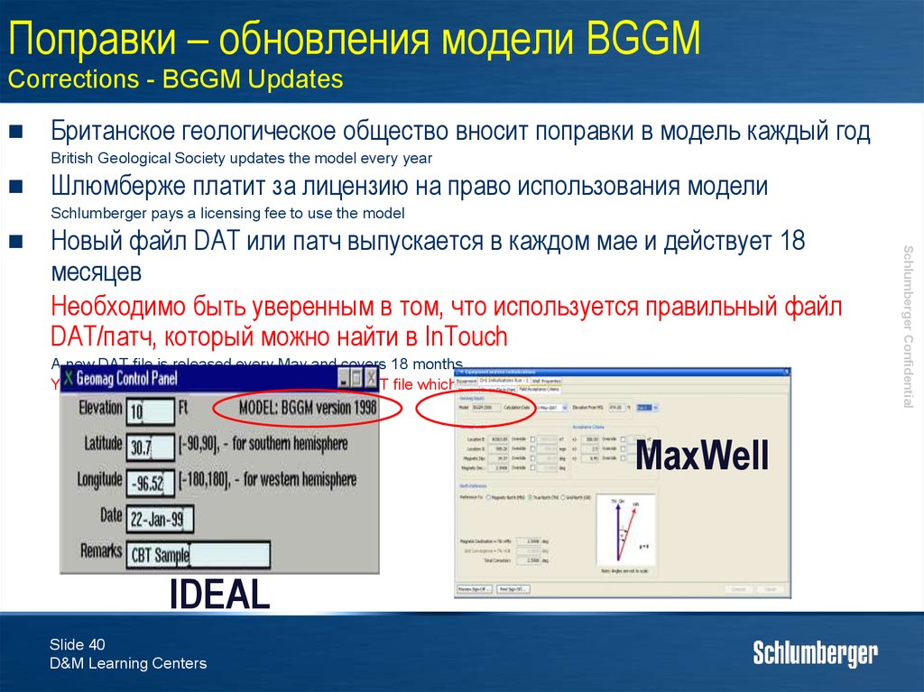
Британское геологическое общество вносит поправки в модель каждый годBritish Geological Society updates the model every year
Шлюмберже платит за лицензию на право использования модели
Schlumberger pays a licensing fee to use the model
Новый файл DAT или патч выпускается в каждом мае и действует 18
месяцев
Необходимо быть уверенным в том, что используется правильный файл
DAT/патч, который можно найти в InTouch
A new DAT file is released every May and covers 18 months
You need to make sure you have the correct DAT file which are available in In-Touch
MaxWell
IDEAL
Slide 40
D&M Learning Centers
Schlumberger Confidential
41. Искажения магнитного поля Magnetic Field Distortion
Искажения магнитного поля Земли
Distortion of Earths Magnetic Field
Временные поля, возникающие на Солнце
Transitory field generated outside the Earth - the Sun
Secular variations of approximately 15 gammas per year - a minor effect
Дневные колебания солнечной активности – примерно 3040 гамма в день – незначительный эффект
Diurnal solar variations on the order of 30 to 40 gammas per day - a minor effect
Циклические «одиннадцатилетние» изменения –
незначительный эффект
The cyclical “eleven years” variation - a minor effect
Магнитные бури достигающие нескольких сот гамма –
значительный эффект
Magnetic storms which may reach several hundred gammas - a major effect
Эффект сильнее проявляется на полюсах
The effect very pronounced at the poles
Schlumberger Confidential
Изменения, происходящие на Земле, примерно 15 гамма в
год – незначительный эффект
42. Магнитное склонение Magnetic Declination
Magnetic Declination is the angle between True North and Magnetic North as measured from TrueNorth
Зависит от местоположения и изменяется со
временем
Depends on location and varies with time
Вычисляется с помощью Geomag в
IDEAL/Maxwell или Drilling Office
Calculated using Geomag in IDEAL* or Drilling Office
Магнитное склонение на западе = «-»
Магнитное склонение на востоке = «+»
Declination West = -ve
Declination East = +ve
Slide 42
D&M Learning Centers
Schlumberger Confidential
Магнитное склонение – это угол между
географическим и магнитным севером,
измеряемый от географического севера
43. Применение магнитного склонения Application of Magnetic Declination
West DeclinationTrue North
East Declination
True North
Magnetic North
Magnetic North
ATN
AMN
AMN
ATN
True North Azimuth (ATn) = Magnetic Azimuth(AMn) +
Magnetic Declination(D)
Slide 43
D&M Learning Centers
Schlumberger Confidential
D
D
44. Упражнение по магнитному склонению Magnetic Declination Practical
Чему равен географический азимут?What are the True North Azimuths?
Mag Dec. = 2.5°E
MWD Az. = 90°
2.
Mag Dec. = -1.7°
MWD Az. = 195°
3.
Mag Dec. = 6.7°W
Gyro Az. = 265°
Slide 44
D&M Learning Centers
Schlumberger Confidential
1.
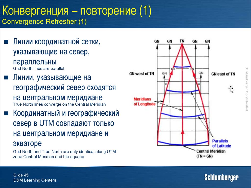
45. Конвергенция – повторение (1) Convergence Refresher (1)
Линии координатной сетки,указывающие на север,
параллельны
Линии, указывающие на
географический север сходятся
на центральном меридиане
True North lines converge on the Central Meridian
Координатный и географический
север в UTM совпадают только
на центральном меридиане и
экваторе
Grid North and True North are only identical along UTM
zone Central Meridian and the equator
Slide 45
D&M Learning Centers
Schlumberger Confidential
Grid North lines are parallel
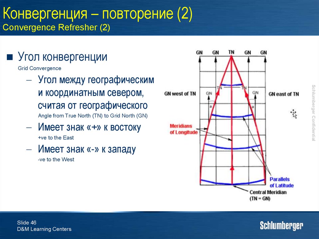
46. Конвергенция – повторение (2) Convergence Refresher (2)
Угол конвергенцииGrid Convergence
Angle from True North (TN) to Grid North (GN)
Имеет знак «+» к востоку
+ve to the East
Имеет знак «-» к западу
-ve to the West
Slide 46
D&M Learning Centers
Schlumberger Confidential
Угол между географическим
и координатным севером,
считая от географического
47. Поправка координатного севера Correction to Grid Azimuth
• КонвергенцияGrid Convergence (Grid Con)
ONLY use this angle if Surveys are to be referenced to Grid North
– Конвергенция даст поправку географического севера на
координатный
Correcting for Grid Con will correct True North to Grid North
– Измеряется от географического севера к координатному
Measured from True North to Grid North
– Конвергенция к западу = «-»
Grid Convergence West = -ve
– Конвергенция к востоку = «+»
Grid Convergence East = +ve
Grid Azimuth = True North Azimuth - Grid Con.
Slide 47
D&M Learning Centers
Schlumberger Confidential
– Применяется только, если азимут измеряется от
координатного севера
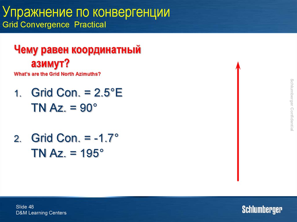
48. Упражнение по конвергенции Grid Convergence Practical
Чему равен координатныйазимут?
What’s are the Grid North Azimuths?
Grid Con. = 2.5°E
TN Az. = 90°
2.
Grid Con. = -1.7°
TN Az. = 195°
Slide 48
D&M Learning Centers
Schlumberger Confidential
1.
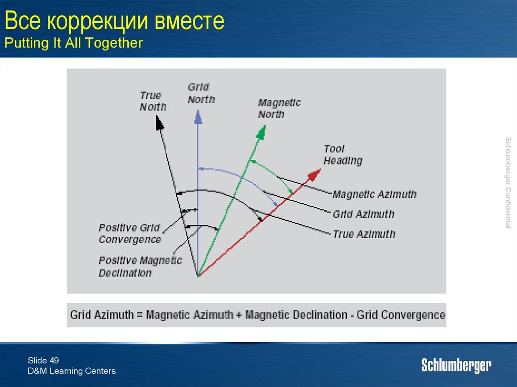
49. Все коррекции вместе Putting It All Together
Schlumberger ConfidentialSlide 49
D&M Learning Centers
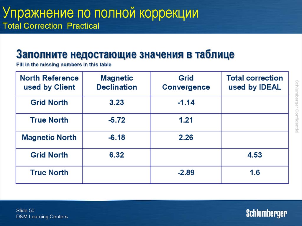
50. Упражнение по полной коррекции Total Correction Practical
Заполните недостающие значения в таблицеFill in the missing numbers in this table
Magnetic
Declination
Grid
Convergence
Grid North
3.23
-1.14
True North
-5.72
1.21
Magnetic North
-6.18
2.26
Grid North
6.32
True North
Slide 50
D&M Learning Centers
Total correction
used by IDEAL
4.53
-2.89
1.6
Schlumberger Confidential
North Reference
used by Client
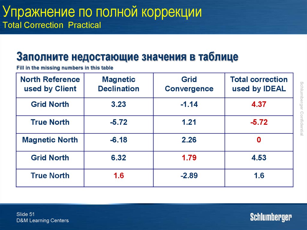
51. Упражнение по полной коррекции Total Correction Practical
Заполните недостающие значения в таблицеFill in the missing numbers in this table
Magnetic
Declination
Grid
Convergence
Total correction
used by IDEAL
Grid North
3.23
-1.14
4.37
True North
-5.72
1.21
-5.72
Magnetic North
-6.18
2.26
0
Grid North
6.32
1.79
4.53
True North
1.6
-2.89
1.6
Slide 51
D&M Learning Centers
Schlumberger Confidential
North Reference
used by Client
52. Теория замеров Survey Theory
Каким образом вычисляетсятраектория между
замерами?
How do we calculate the well path between
Surveys?
Slide 52
D&M Learning Centers
Schlumberger Confidential
3.
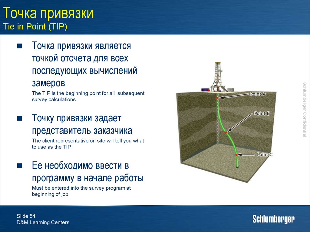
53. Расчет замеров Survey Calculations
Вычисления начинаются сизвестной точки в
пространстве, называемой
«точкой привязки»
Точка привязки быть на
поверхности или в
обговоренном месте на
траектории скважины
The TIP can be the surface location or an agreed
point in the wellbore.
Далее по вычислениям
замеров выстраивается
траектория скважины
Survey calculations then compute a well profile.
Slide 53
D&M Learning Centers
Schlumberger Confidential
We start at a known point in space, which is called
the “tie in point” (TIP).
54. Точка привязки Tie in Point (TIP)
The TIP is the beginning point for all subsequentsurvey calculations
Точку привязки задает
представитель заказчика
The client representative on site will tell you what
to use as the TIP
Ее необходимо ввести в
программу в начале работы
Must be entered into the survey program at
beginning of job
Slide 54
D&M Learning Centers
Schlumberger Confidential
Точка привязки является
точкой отсчета для всех
последующих вычислений
замеров
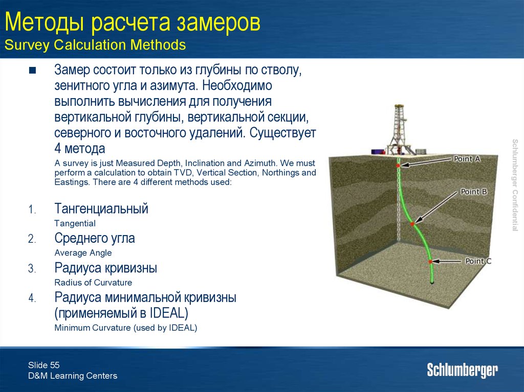
55. Методы расчета замеров Survey Calculation Methods
A survey is just Measured Depth, Inclination and Azimuth. We mustperform a calculation to obtain TVD, Vertical Section, Northings and
Eastings. There are 4 different methods used:
1.
Тангенциальный
Tangential
2.
Среднего угла
Average Angle
3.
Радиуса кривизны
Radius of Curvature
4.
Радиуса минимальной кривизны
(применяемый в IDEAL)
Minimum Curvature (used by IDEAL)
Slide 55
D&M Learning Centers
Schlumberger Confidential
Замер состоит только из глубины по стволу,
зенитного угла и азимута. Необходимо
выполнить вычисления для получения
вертикальной глубины, вертикальной секции,
северного и восточного удалений. Существует
4 метода
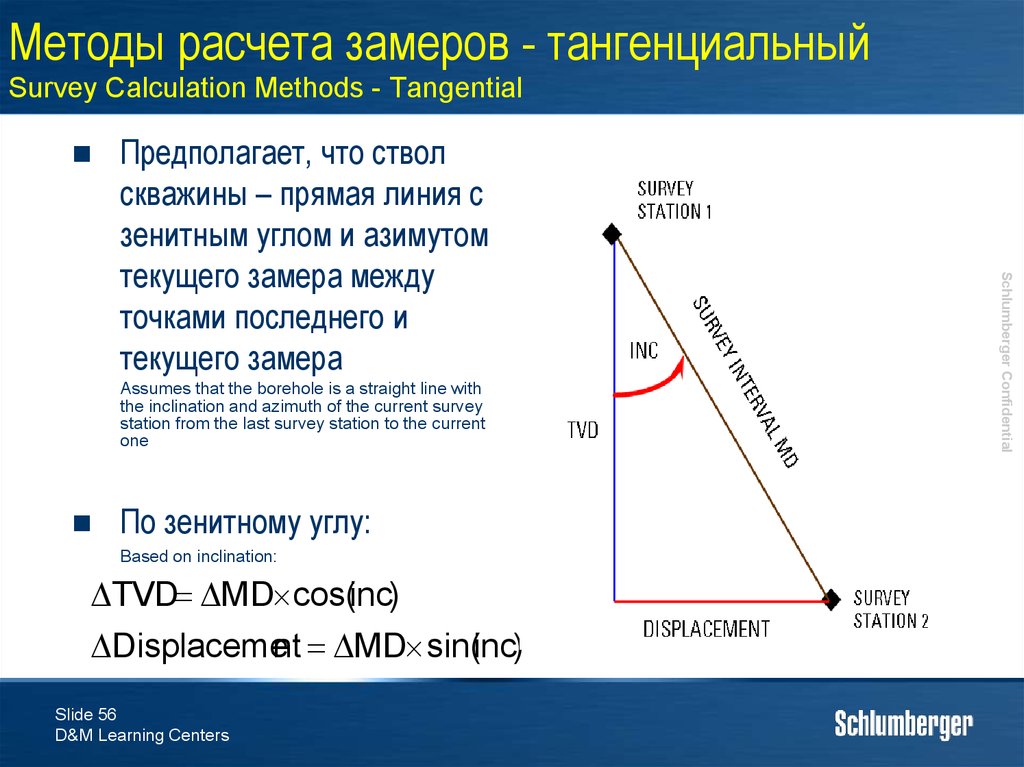
56. Методы расчета замеров - тангенциальный Survey Calculation Methods - Tangential
Assumes that the borehole is a straight line withthe inclination and azimuth of the current survey
station from the last survey station to the current
one
По зенитному углу:
Based on inclination:
TVD MD cos(inc)
Displacement MD sin(inc)
Slide 56
D&M Learning Centers
Schlumberger Confidential
Предполагает, что ствол
скважины – прямая линия с
зенитным углом и азимутом
текущего замера между
точками последнего и
текущего замера
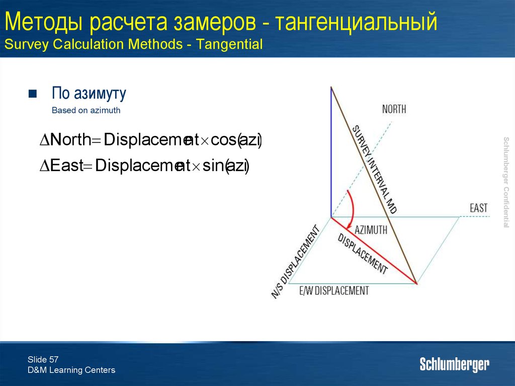
57. Методы расчета замеров - тангенциальный Survey Calculation Methods - Tangential
По азимутуBased on azimuth
Slide 57
D&M Learning Centers
Schlumberger Confidential
North Displacement cos(azi)
East Displacement sin(azi)
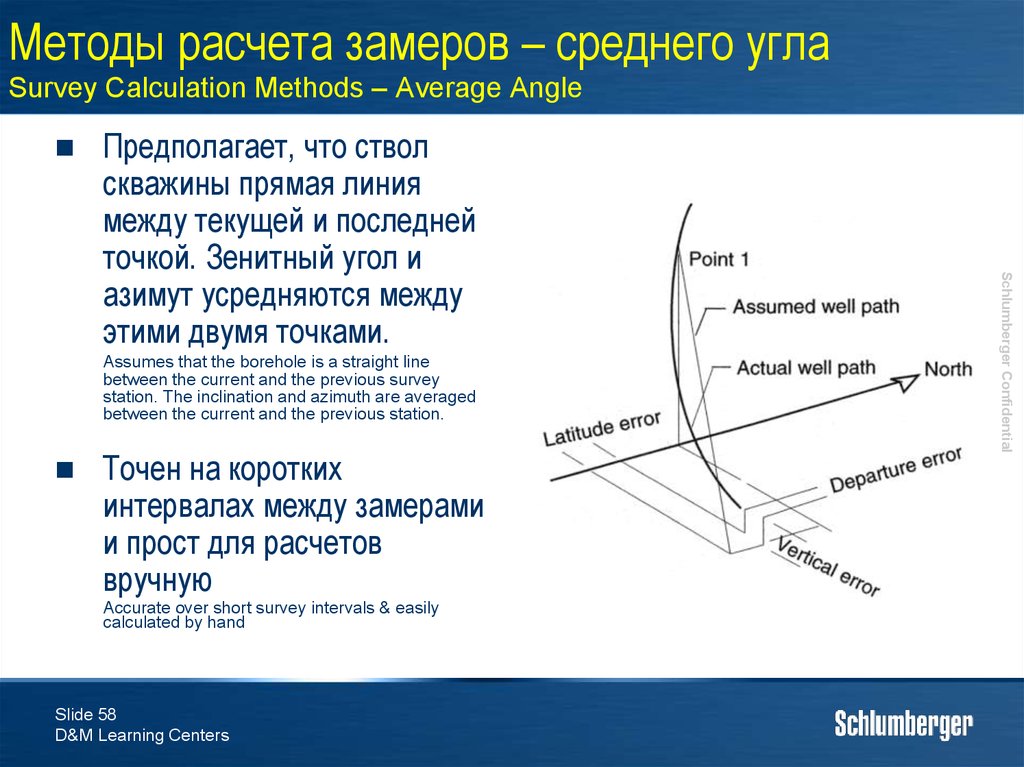
58. Методы расчета замеров – среднего угла Survey Calculation Methods – Average Angle
Assumes that the borehole is a straight linebetween the current and the previous survey
station. The inclination and azimuth are averaged
between the current and the previous station.
Точен на коротких
интервалах между замерами
и прост для расчетов
вручную
Accurate over short survey intervals & easily
calculated by hand
Slide 58
D&M Learning Centers
Schlumberger Confidential
Предполагает, что ствол
скважины прямая линия
между текущей и последней
точкой. Зенитный угол и
азимут усредняются между
этими двумя точками.
59. Методы расчета замеров – среднего угла Survey Calculation Methods – Average Angle
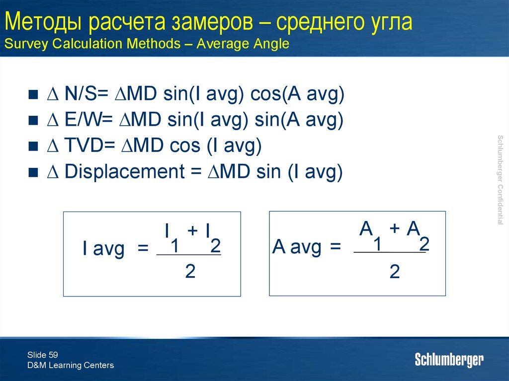
N/S= MD sin(I avg) cos(A avg)E/W= MD sin(I avg) sin(A avg)
TVD= MD cos (I avg)
Displacement = MD sin (I avg)
Slide 59
D&M Learning Centers
A +A
1
2
A avg =
2
Schlumberger Confidential
I +I
I avg = 1 2
2
60. Методы расчета замеров – радиус кривизны Survey Calculation Methods – Radius of Curvature
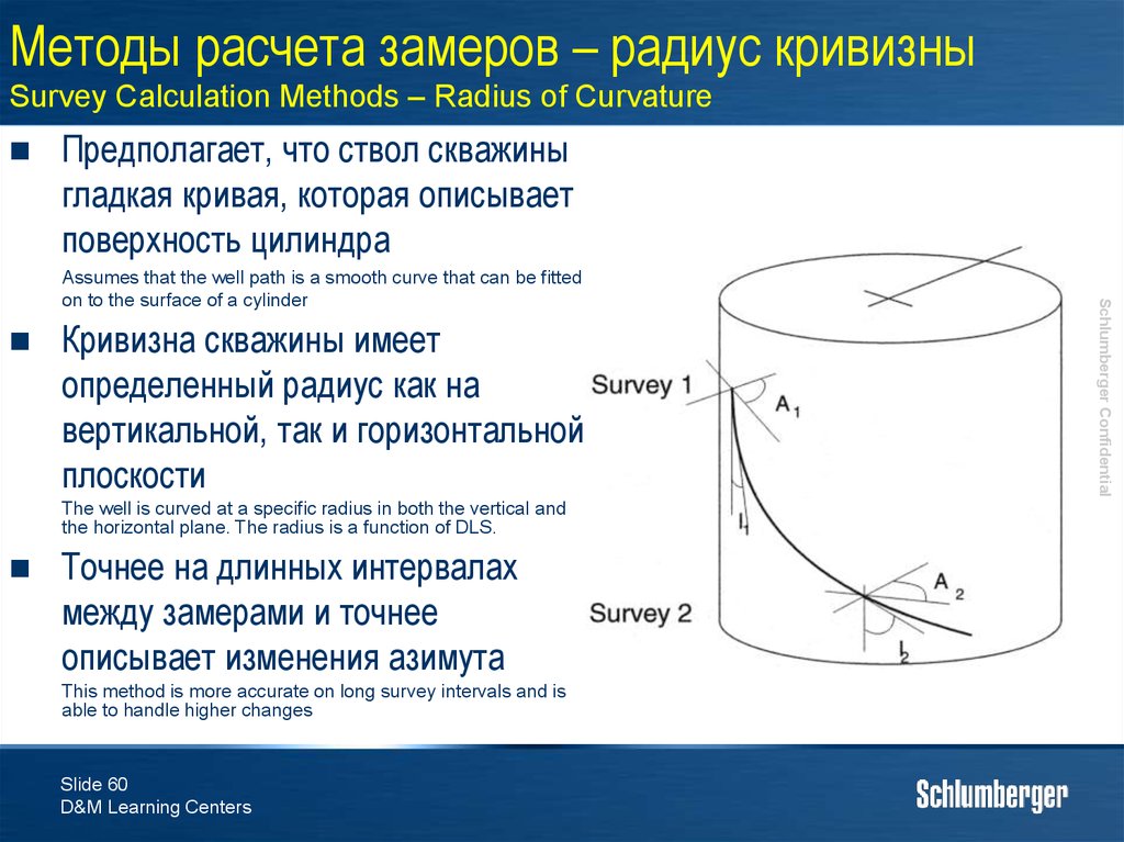
Предполагает, что ствол скважиныгладкая кривая, которая описывает
поверхность цилиндра
Кривизна скважины имеет
определенный радиус как на
вертикальной, так и горизонтальной
плоскости
The well is curved at a specific radius in both the vertical and
the horizontal plane. The radius is a function of DLS.
Точнее на длинных интервалах
между замерами и точнее
описывает изменения азимута
This method is more accurate on long survey intervals and is
able to handle higher changes
Slide 60
D&M Learning Centers
Schlumberger Confidential
Assumes that the well path is a smooth curve that can be fitted
on to the surface of a cylinder
61. Методы расчета замеров – радиус минимальной кривизны Survey Calculation Methods – Minimum Curvature
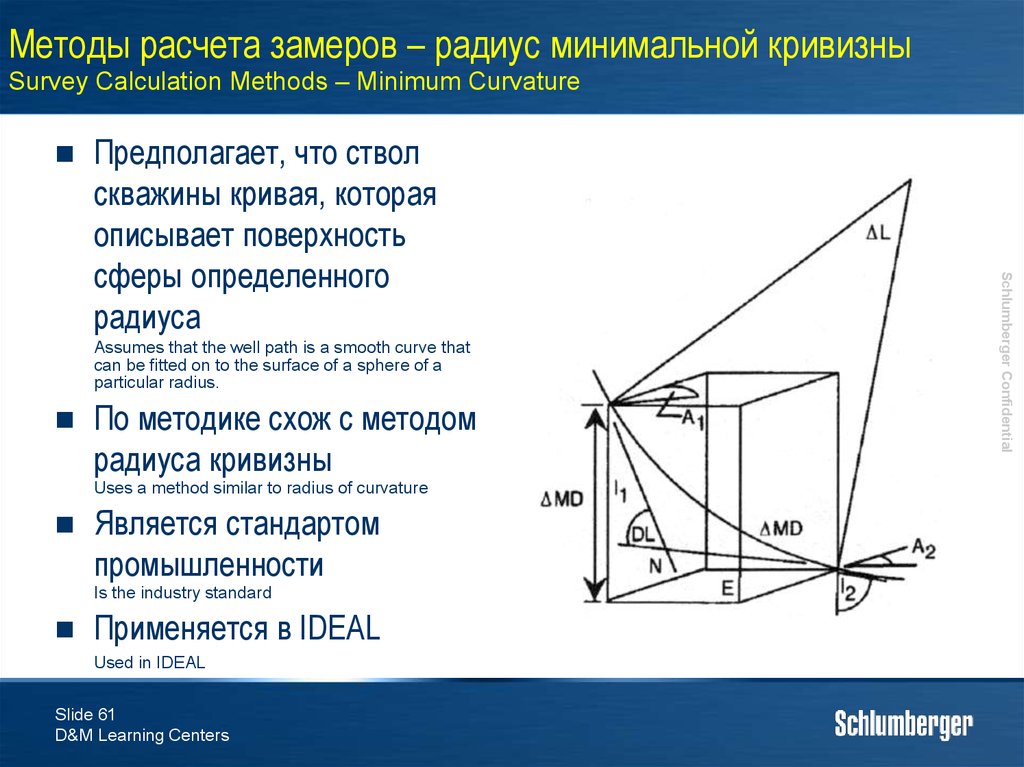
Assumes that the well path is a smooth curve thatcan be fitted on to the surface of a sphere of a
particular radius.
По методике схож с методом
радиуса кривизны
Uses a method similar to radius of curvature
Является стандартом
промышленности
Is the industry standard
Применяется в IDEAL
Used in IDEAL
Slide 61
D&M Learning Centers
Schlumberger Confidential
Предполагает, что ствол
скважины кривая, которая
описывает поверхность
сферы определенного
радиуса
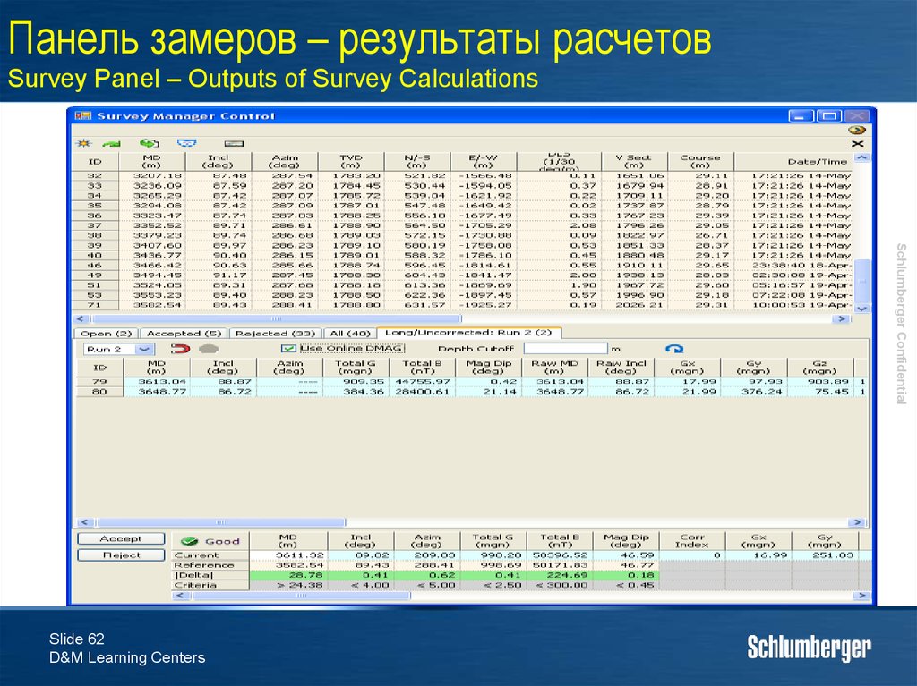
62. Панель замеров – результаты расчетов Survey Panel – Outputs of Survey Calculations
Schlumberger ConfidentialSlide 62
D&M Learning Centers
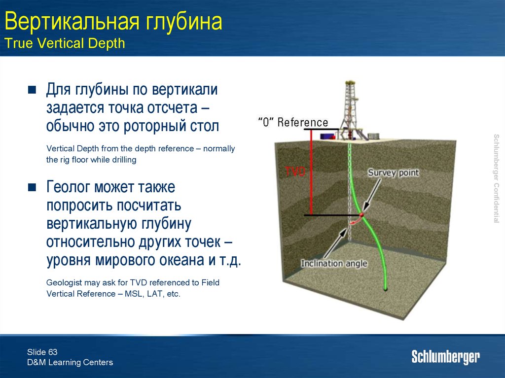
63. Вертикальная глубина True Vertical Depth
Vertical Depth from the depth reference – normallythe rig floor while drilling
Геолог может также
попросить посчитать
вертикальную глубину
относительно других точек –
уровня мирового океана и т.д.
Geologist may ask for TVD referenced to Field
Vertical Reference – MSL, LAT, etc.
Slide 63
D&M Learning Centers
Schlumberger Confidential
Для глубины по вертикали
задается точка отсчета –
обычно это роторный стол
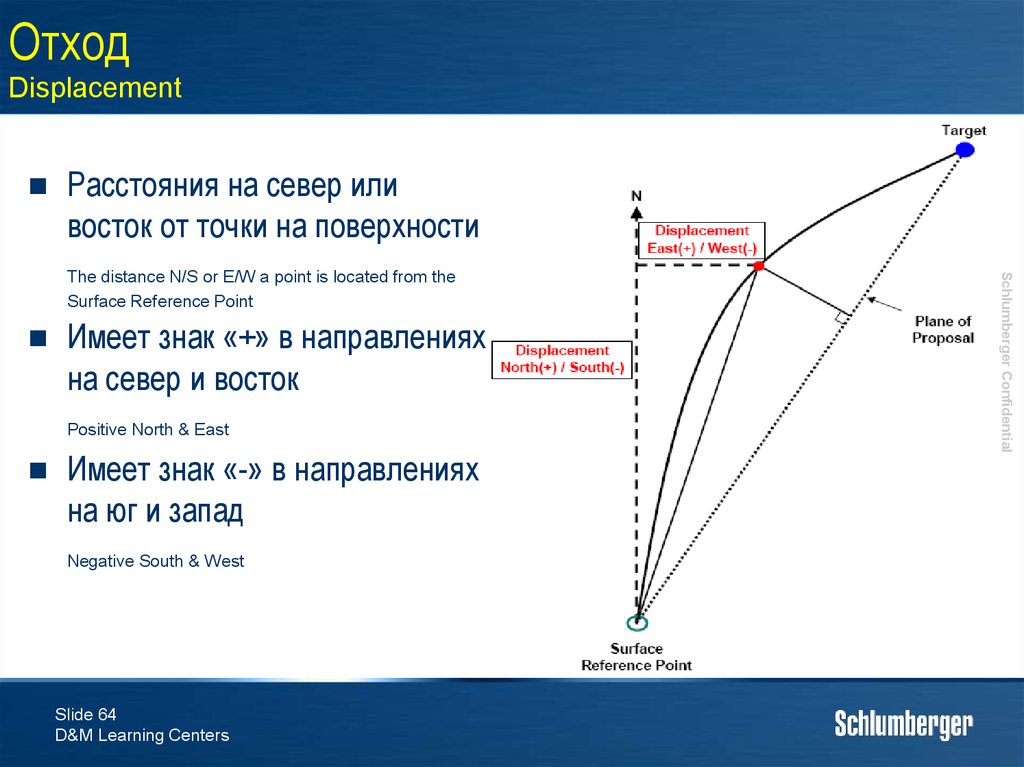
64. Отход Displacement
Расстояния на север иливосток от точки на поверхности
Имеет знак «+» в направлениях
на север и восток
Positive North & East
Имеет знак «-» в направлениях
на юг и запад
Negative South & West
Slide 64
D&M Learning Centers
Schlumberger Confidential
The distance N/S or E/W a point is located from the
Surface Reference Point
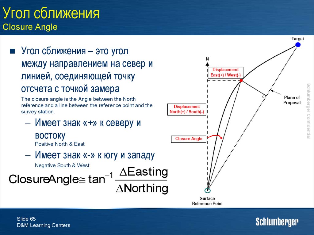
65. Угол сближения Closure Angle
The closure angle is the Angle between the Northreference and a line between the reference point and the
survey station.
Имеет знак «+» к северу и
востоку
Positive North & East
Имеет знак «-» к югу и западу
Negative South & West
ΔEasting
ClosureAngle tan
Northing
1
Slide 65
D&M Learning Centers
Schlumberger Confidential
Угол сближения – это угол
между направлением на север и
линией, соединяющей точку
отсчета с точкой замера
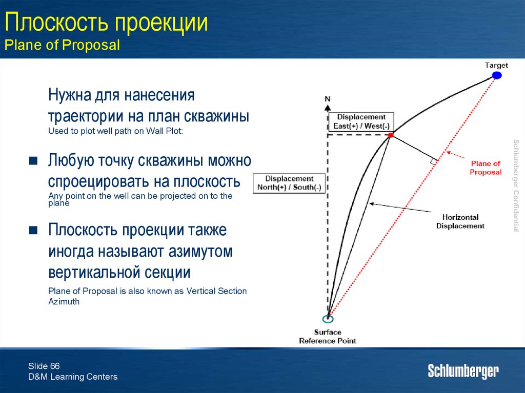
66. Плоскость проекции Plane of Proposal
Нужна для нанесениятраектории на план скважины
Used to plot well path on Wall Plot:
Любую точку скважины можно
спроецировать на плоскость
Any point on the well can be projected on to the
plane
Плоскость проекции также
иногда называют азимутом
вертикальной секции
Plane of Proposal is also known as Vertical Section
Azimuth
Slide 66
D&M Learning Centers
Schlumberger Confidential
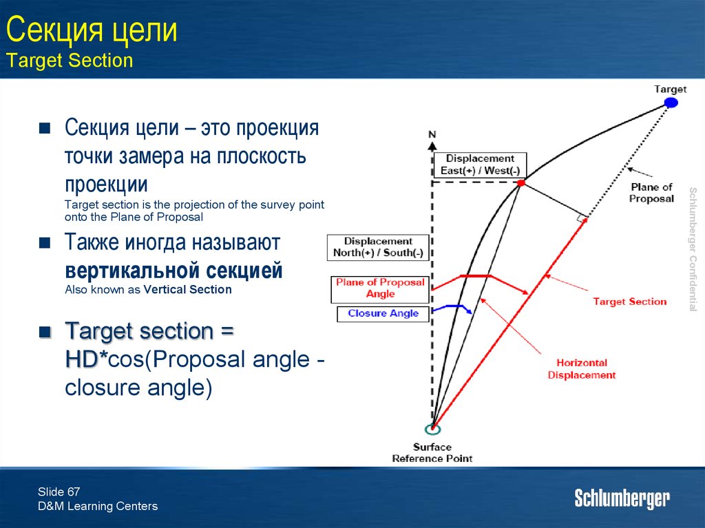
67. Секция цели Target Section
Target section is the projection of the survey pointonto the Plane of Proposal
Также иногда называют
вертикальной секцией
Also known as Vertical Section
Target section =
HD*cos(Proposal angle closure angle)
Slide 67
D&M Learning Centers
Schlumberger Confidential
Секция цели – это проекция
точки замера на плоскость
проекции
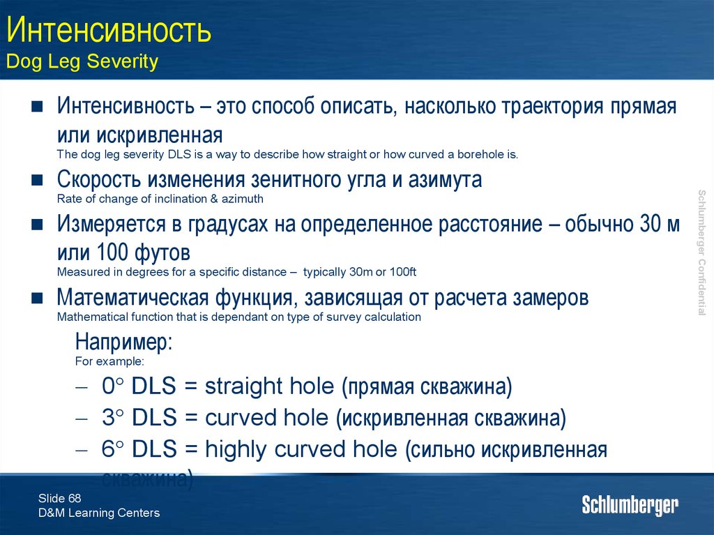
68. Интенсивность Dog Leg Severity
Интенсивность – это способ описать, насколько траектория прямаяили искривленная
The dog leg severity DLS is a way to describe how straight or how curved a borehole is.
Скорость изменения зенитного угла и азимута
Rate of change of inclination & azimuth
Измеряется в градусах на определенное расстояние – обычно 30 м
или 100 футов
Measured in degrees for a specific distance – typically 30m or 100ft
Математическая функция, зависящая от расчета замеров
Mathematical function that is dependant on type of survey calculation
Например:
For example:
0° DLS = straight hole (прямая скважина)
3° DLS = curved hole (искривленная скважина)
6° DLS = highly curved hole (сильно искривленная
скважина)
Slide 68
D&M Learning Centers
Schlumberger Confidential
69. Точность инклинометрии Survey Accuracy
Таким образом все перечисленные параметры получаются путемВЫЧИСЛЕНИЙ, а не фактическими измерениям
All of these variables are therefore CALCULATIONS and are not actual measurements
Любая ошибка в измерениях или в методе вычисления
отражается на расчете местоположения
Any errors made in the survey measurement or in the calculation method are therefore transferred to the position
calculations.
Результаты расчетов используются для нанесения текущего
положения траектории на план скважины для контроля курса
скважины по направлению к цели
The numbers generated from the calculations are used to plot the current position of the well on the Wall Plot to
make sure that the well is on course to hit the target.
Slide 69
D&M Learning Centers
Schlumberger Confidential
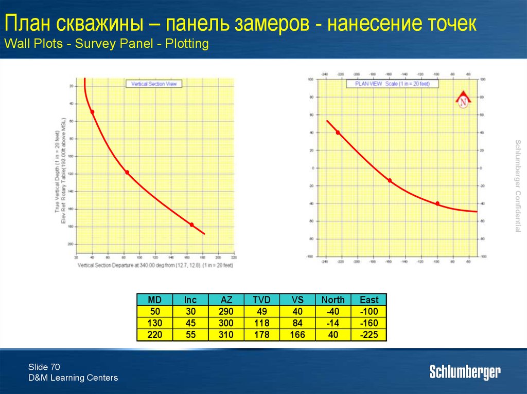
70. План скважины – панель замеров - нанесение точек Wall Plots - Survey Panel - Plotting
Schlumberger ConfidentialMD
50
130
220
Slide 70
D&M Learning Centers
Inc
30
45
55
AZ
290
300
310
TVD
49
118
178
VS
40
84
166
North
-40
-14
40
East
-100
-160
-225
71. Влияние места и времени проведения замеров Effect of Surveying Spacing & Timing
Теория замеровSurvey Theory
Эллипсы неопределенности
Ellipses Of Uncertainty
Slide 74
D&M Learning Centers
Schlumberger Confidential
4.
72. Влияние места и времени проведения замеров Effect of Surveying Spacing & Timing
Эллипс неопределенностиEllipse of Uncertainty
В чем проблема?
Problem?
Is it accurate to represent the well as a line on the wall plot?
Любой замер инклинометрии имеет известную степень
погрешности. Эта погрешность значит то, что
необходимо принимать в расчет «позиционную
неопределенность» при планировании скважины
All survey measurements have built in errors. These errors mean that you must take into account “positional
uncertainty” when planning a well.
Погрешность может быть крайне высокой
These uncertainties can become extremely large!
Slide 75
D&M Learning Centers
Schlumberger Confidential
Насколько точно представлять скважину как линию на
плане скважины?
73. Влияние места и времени проведения замеров Effect of Surveying Spacing & Timing
Эллипс неопределенностиEllipse of Uncertainty
Замер включает в себя три измерения, таким образом имеет три источника
погрешностей
A Survey has three measurements and so three sources of error.
Глубина – зависит от точности контроля глубины. При соблюдении
норм ошибка должна быть не велика
Depth – depends upon the accuracy of depth tracking. If the standards are followed then this error should be small
Зенитный угол – погрешности в измерениях зенитного угла
проявляются в погрешности расчета вертикальной глубины.
Акселерометры дают высокую точность и обычно эта ошибка не велика
Inclination – errors in the Inclination measurement manifest themselves as errors in the calculated TVD.
Accelerometers give excellent TVD accuracy so this error is usually small
Азимут – точность магнетометров страдает от различных факторов,
искажающих магнитное поле, в котором находится прибор. Таким
образом это на данный момент самый большой источник погрешности.
Azimuth - Magnetometer accuracy suffers from the various factors interfering with the overall magnetic field around
the tool. This is by far the largest error.
Slide 76
D&M Learning Centers
Schlumberger Confidential
74. Теория замеров Survey Theory
Эллипс неопределенностиEllipse of Uncertainty
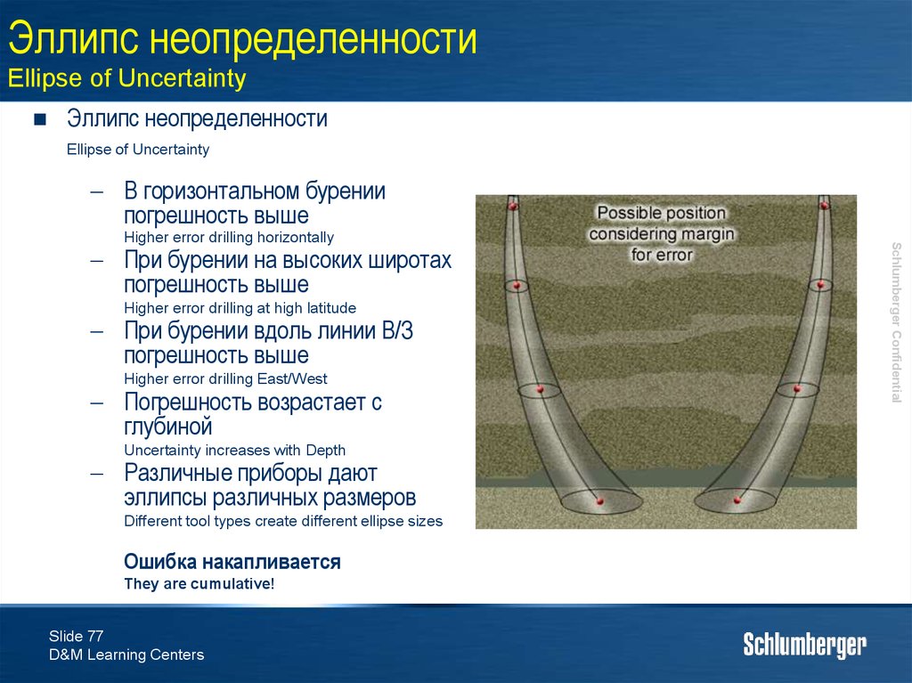
Эллипс неопределенности
Ellipse of Uncertainty
В горизонтальном бурении
погрешность выше
При бурении на высоких широтах
погрешность выше
Higher error drilling at high latitude
При бурении вдоль линии В/З
погрешность выше
Higher error drilling East/West
Погрешность возрастает с
глубиной
Uncertainty increases with Depth
Различные приборы дают
эллипсы различных размеров
Different tool types create different ellipse sizes
Ошибка накапливается
They are cumulative!
Slide 77
D&M Learning Centers
Schlumberger Confidential
Higher error drilling horizontally
75. Эллипс неопределенности Ellipse of Uncertainty
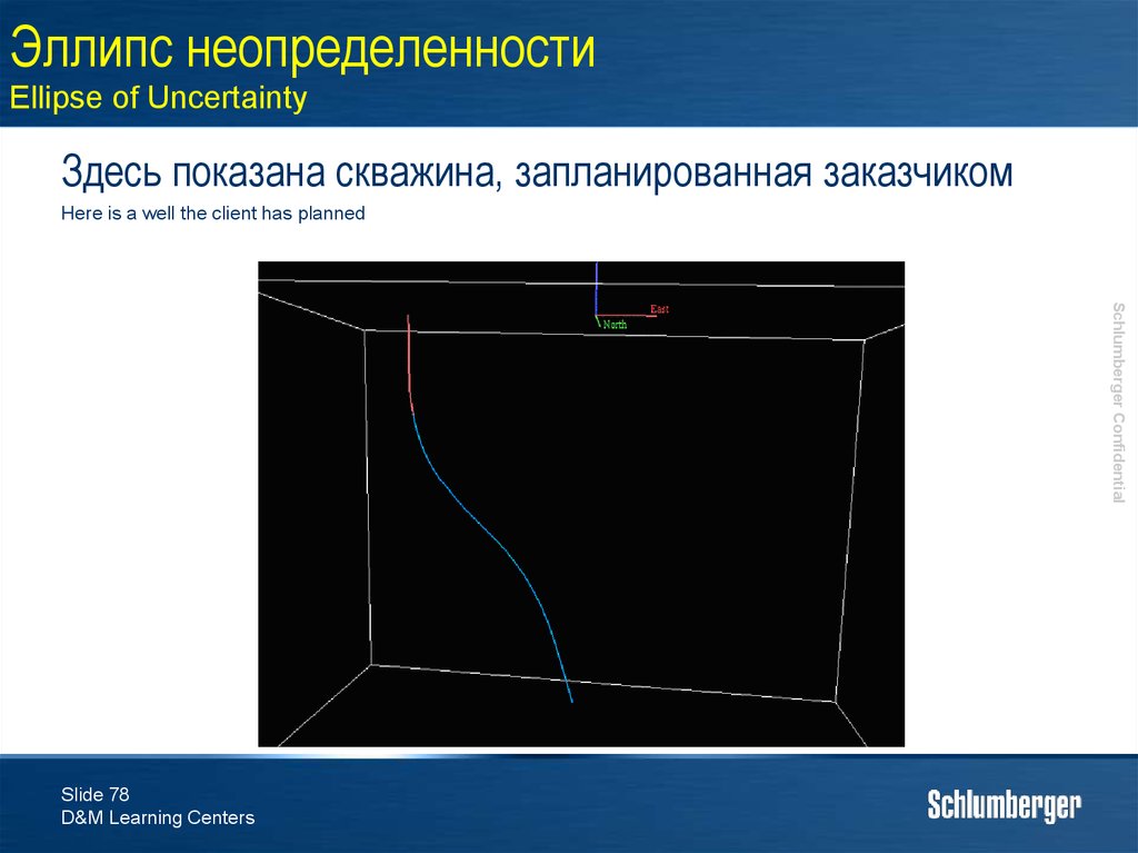
Здесь показана скважина, запланированная заказчикомHere is a well the client has planned
Schlumberger Confidential
Slide 78
D&M Learning Centers
76. Эллипс неопределенности Ellipse of Uncertainty
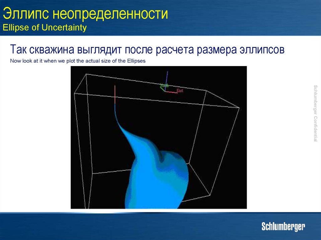
Так скважина выглядит после расчета размера эллипсовNow look at it when we plot the actual size of the Ellipses
Schlumberger Confidential
77. Эллипс неопределенности Ellipse of Uncertainty
Не забываем, что рядом есть еще скважиныRemember that there are other Wells in the Field.
Schlumberger Confidential
78. Эллипс неопределенности Ellipse of Uncertainty
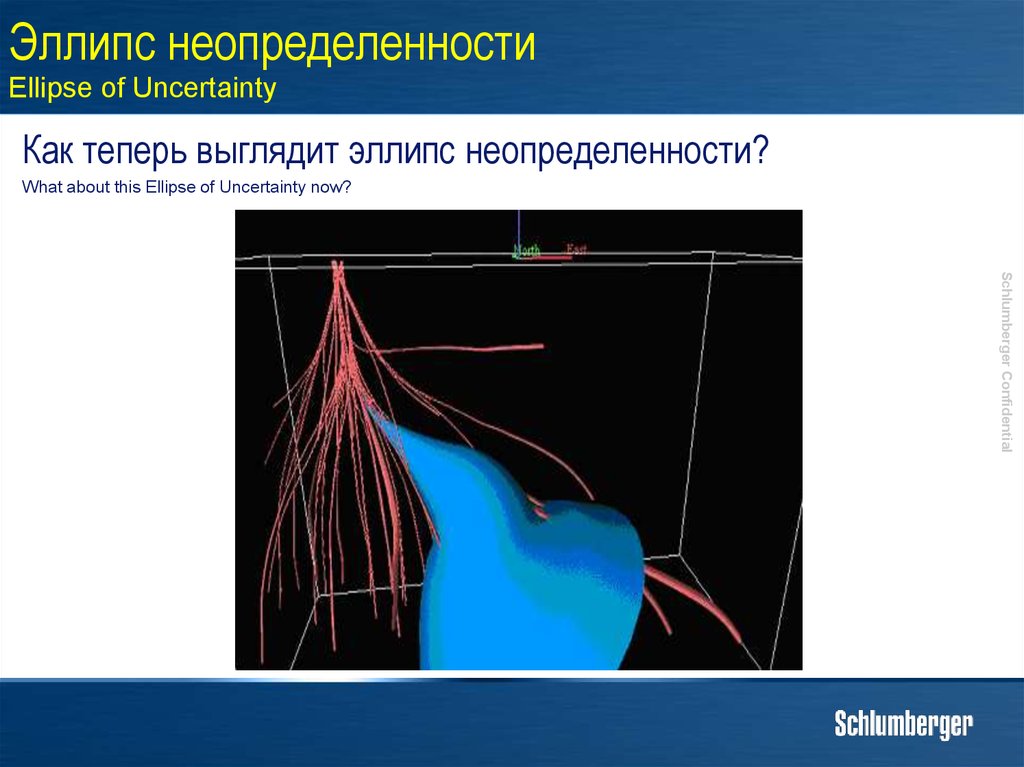
Как теперь выглядит эллипс неопределенности?What about this Ellipse of Uncertainty now?
Schlumberger Confidential
79. Эллипс неопределенности Ellipse of Uncertainty
Что это значит?What does this mean?
Точность и качество замеров инклинометрии, которые
мы делаем играют критическую роль!!!
The accuracy and quality of the survey measurements you take are critically important!!!
Любые помехи, действующие на замеры инклинометрии
имеют огромный эффект на эллипсы неопределенности
и расчет местоположения
Any interference you have in your survey measurements has a very large effect on the EOU and position
calculations.
Slide 82
D&M Learning Centers
Schlumberger Confidential
80. Эллипс неопределенности Ellipse of Uncertainty
Задачи модуля - обзорModule Objectives - Review
По окончании этого модуля инженер должен уметь:
At the end of this module you should be able to
Перечислить и описать различные типы инклинометров
Объяснить основные преимущества гироскопических
инклинометров
Explain the major benefit of Gyro based survey measurements
Обозначить все элементы, определяющие точку замера
Describe all the elements that define a survey station
Описать как вычисляется зенитный угол скважины
Describe how we calculate the Inclination measurement
Описать как вычисляется азимут
Describe how we calculate the Azimuth measurement
Перечислите и опишите критерии качества замера
List and describe the Field Acceptance Criteria
Slide 83
D&M Learning Centers
Schlumberger Confidential
List and describe the different types of Survey Tools
81. Эллипс неопределенности Ellipse of Uncertainty
Задачи модуля - обзорModule Objectives - Review
По окончании этого модуля инженер должен уметь:
At the end of this module you should be able to
List and describe the corrections applied to Inclination and Magnetic Azimuth and be able to calculate
them.
Описать различные методы вычисления замеров и
обозначить метод, применяемый в IDEAL/Maxwell
Explain different survey calculation methods and identify which survey calculation method is used by
IDEAL.
Объяснить точку привязки и каждый из результатов
вычисления замера
Describe a Tie In Point and all the outputs from the survey calculations
Объяснить, что такое эллипс неопределенности и чем он
важен
Explain what an Ellipse of uncertainty is and why it is important
Slide 84
D&M Learning Centers
Schlumberger Confidential
Перечислить коррекции, которые применяются к
измерениям зенитного угла и магнитного азимута












 Математика
 География


