


 Английский язык
Похожие презентации:


Unit 9. Theme: geographical location and boundaries
1.
UNIT 9THEME: GEOGRAPHICAL LOCATION AND
BOUNDARIES
2.
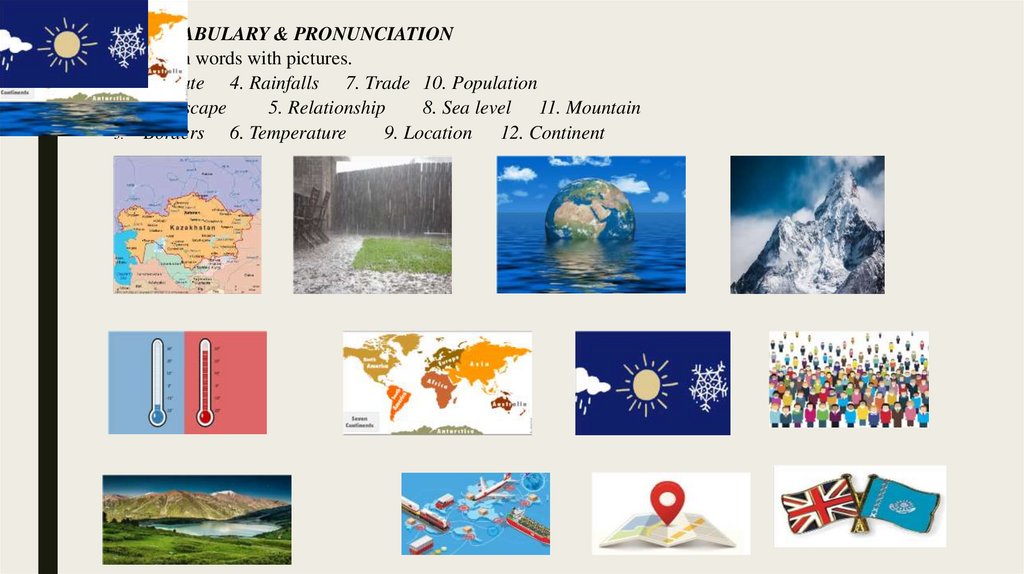
1. VOCABULARY & PRONUNCIATIONa. Match words with pictures.
1.
Climate 4. Rainfalls 7. Trade 10. Population
2.
Landscape
5. Relationship
8. Sea level 11. Mountain
3.
Borders 6. Temperature
9. Location 12. Continent
3.
Read the following words and notice their pronunciation. Guess their meaning.To consist [kənˈsɪst]
Height [haɪt]
To occupy [ˈɒk.jə.paɪ]
Length [leŋθ]
Average [ˈæv.ər.ɪdʒ]
Sq. km. – square kilometer [skweər ˈkɪl·əˌmit̬·ər]
Area [ˈeə.ri.ə]
To include [ɪnˈkluːd]
b.
Practice your pronunciation and try to memorize the following rhymes.
***
A red sky at night is the shepherds delight;
A red sky in the morning is the shepherd’s
warning.
***
A sailor went to sea to see what he could
see.
And all that he could see was sea, sea, sea.
***
The north wind doth blow, and we shall
have snow,
And what will poor robin do then, poor
thing?
O, he’ll go to the barn, and to keep himself
warm
He’ll hide his head under his wing, poor
thing.
***
The south wind brings wet weather,
The north wind wet and cold together;
The west wind always brings us rain,
The east wind blows it back again.
***
Rain, rain, go away, come again another day!
Little children want to play!
Ra in, rain, go to Spain, never show your face
again!
4.
2. READING & SPEAKINGa. Pre-reading task: before you read the text, try to answer these questions:
1.
What is now the name of the country you live in? What was it before?
2.
How many cities are there in Kazakhstan? Can you name at least 6?
3.
What do you know about the geographical location of Kazakhstan?
4.
Can you name some of our “neighbors”? What do you know about relationship of Kazakhstan with them?
5.
Can you answer on the same questions but in accordance to the ESC?
b. While-reading task: Do a group activity. Divide into 4 groups →Choose one of the texts →Scan it →Work
on unfamiliar words →Make questions to the text →Be ready to present your text to other groups and ask
them questions.
5.
TEXT A THE LANDSCAPE OF KAZAKHSTANKazakhstan is mountainous along its far eastern and southeastern borders, where much of the
forested Altai and Tian Shan ranges remain snowcapped throughout the year and with many elevated
peaks exceeding 6,500 meters.
Kazakhstan's highest peak is Khan Tengri, whose summit reaches 22,949 ft. (6,995 m).
Just over 70% of the country is a desert or semi-desert dry mix of eroded lowlands, grasslands
and sandy areas.
The very dry Kirgiz (or Kaazakh) Steppe region at 308,881 sq miles (800,000 sq km) is the
largest plain of its type in the world. Weather conditions on the steepe are frequently inhospitable,
and it's a very windy stretch of land.
Along the edges of the landlocked Caspian Sea, the land dips way below sea level in some
areas. In the west along its border with the Russian Federation, rolling prairies and forests dominate
the landscape.
The most important rivers include the Ishim, Irtush, Syr Dayra, Tobol and Ural. The Caspian
Sea and Aral Sea, and lakes Alakal, Balkhash, Tengiz and Zaysan are the largest bodies of water.
6.
TEXT B THE CLIMATE OF KAZAKHSTANThe territory of Kazakhstan stretches for more than 3000 km from west to east and almost 2000 km from
north to south. Climatic peculiarities are due to the amplitude of the country. Whereas temperature can hit 50
degrees below zero in the north in winter, in summer in the south melons ripen and cotton grow. The climate of
Kazakhstan (excluding south) is sharply continental with average temperature between -4
°C and -19 °C in January and between +19…+26°C in July. In winter temperature may decrease down to 45°C,
and in summer rise up to +30.
One can experience all four seasons on the territory of Kazakhstan with frosty winter, blossoming spring,
heating summer and scarlet autumn. Cold winter starts in November and lasts till the end of April. The influence of
Arctic air masses leads to a strong cold (up to -50 С°). Springs are short and changeable – from mid of April to end
May. Besides spring weather is very unstable: clear warm day may suddenly turn into cold. Dry hot summer begins
in the end of May and lasts till mid September, with temperatures sometimes going up to +35...+40 С°. Autumn
with its stable weather and night frosts begin in the end of September and lasts till the beginning of November.
The highest temperature in Kazakhstan was registered in the city of Turkestan (South Kazakhstan) with +49
С°. The lowest was observed in the city of Atbasar (Akmola region) -57 С°. Besides, Astana is the coldest city in
the world after Ulan-Bator however it is not an obstacle for the capital city to warm guests with its warm
hospitality.
7.
TEXT C GEOGRAPHICAL SITUATION OF KAZAKHSTANKazakhstan is located in Central Asia and Eastern Europe at 48°N 68°E Coordinates: 48°N 68°E. With an
area of about 2,724,800 square kilometers, Kazakhstan is more than twice the combined size of the other four
Central Asian states and 60% larger than Alaska. The country borders on Turkmenistan, Uzbekistan, and
Kyrgyzstan to the south; Russia to the north; Russia and the Caspian Sea to the west; and China's Xinjiang Uygur
Autonomous Region to the east.
Kazakhstan is located on the junction of two continents - Europe and Asia, between 45 and 87 degrees of east
longitude, 40 and 55 degrees of northern breadth. Kazakhstan occupies a square equal to 2724,9 thousand sq. km.
(1048,3 thousand sq. miles) also is stretching to east from the Caspian sea and
Volga's of plains up to mountain Altai from Tjan-Shan foothills in the south and southeast up to the WestSiberian
lowland in north. The extent of it's territory exceeds 3000 kms from west to east (1150 miles), from the south to
north - 1700 kms (650 miles). Kazakhstan is on the ninth place in the world considering the territory occupied, i.e.
USA, Brazil, Australia, India and Argentina enter the top ten of largest states of the world - after Russia, Canada,
China. On Kazakhstan's territory can contain seven largest European states as France, Spain, Sweden, Germany,
Finland, Italy and Great Britain, or such states of Asia, as Pakistan, Turkey, Iraq, Japan and Vietnam taken
together. Only this can testify the huge potential possibilities of the region on the globe.
8.
TEXT D THE GEOGRAPHY OF GREAT BRITAINTo the west of the continent of Europe there lie two large islands called the British Isles. The larger of these islands is known
as Great Britain and it consists of England, Scotland and Wales. The smaller island is Ireland with Northern Ireland and the Irish
Republic.
England is the southern and the central part of Great Britain. Scotland is in the north of the island and Wales is in the west.
Northern Ireland is situated in the north-eastern part of Ireland. England, Scotland, Wales and Northern Ireland form the United
Kingdom of Great Britain and Northern Ireland.
Great Britain is washed all around by water. It is washed by the Atlantic Ocean and the Irish Sea in the west and the eastern
coast is washed by the North Sea. The southern coast is washed by the English Channel. The narrowest part of the Channel, the
Straight of Dover, is only 32 kilometers wide.
The British Isles have no high mountains. Scotland is a mountainous country. Here there is the main chain of mountains which
is called the Grampians and its highest peak is Ben Nevis which is 4 400 feet high. Mountains which separate Scotland and England
are called the Cheviot Hills. In England the Pennine Chain runs down from the north through the center. In Wales there are the
Cambrian Mountains. Its peak Snowdon is in the North Wales. Ireland is covered with mountains and hills.
The British Isles have a lot of rivers, but they are not very long. The longest river is the Severn which flows south-west into the
Irish Sea. The other important rivers are the Thames in England on which London stands and the Clyde in Scotland where Glasgow
is situated. Many rivers in England and Scotland are joined by canals. There are a lot of lakes in Great Britain and the most famous
lakes are in the Lake District in the north-west of England. There are no great woods on the British Isles now. Historically the most
famous forest is Sherwood Forest in the east of England. It was the home of Robin Hood.
The climate of the British Isles is not very cold in winter and never very hot in summer. The rivers do not freeze in winter and
snow never lies on the ground for long. In winter thick fogs cover Britain. The British Isles are warmed by the Gulf Stream, as a
result the temperature in Britain is higher than in Moscow and St. Petersburg which are between the same parallels. It often rains in
Great Britain in all seasons. The mild and damp climate is very good for agriculture.
9.
c. Post reading task: Complete the table. If there is no information in the text, find it in other sources(Wikipedia, Google, books, etc.)
Kazakhstan
Location
Neighbors
Total area
Climate
Temperature
Main cities
Territory,
landscape
Population
Other facts
Great Britain
10.
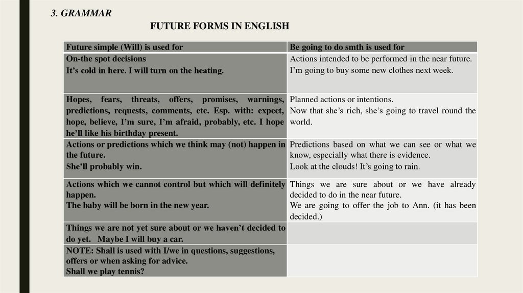
3. GRAMMARFUTURE FORMS IN ENGLISH
Future simple (Will) is used for
On-the spot decisions
It’s cold in here. I will turn on the heating.
Be going to do smth is used for
Actions intended to be performed in the near future.
I’m going to buy some new clothes next week.
Hopes, fears, threats, offers, promises, warnings,
predictions, requests, comments, etc. Esp. with: expect,
hope, believe, I’m sure, I’m afraid, probably, etc. I hope
he’ll like his birthday present.
Actions or predictions which we think may (not) happen in
the future.
She’ll probably win.
Planned actions or intentions.
Now that she’s rich, she’s going to travel round the
world.
Predictions based on what we can see or what we
know, especially what there is evidence.
Look at the clouds! It’s going to rain.
Actions which we cannot control but which will definitely Things we are sure about or we have already
happen.
decided to do in the near future.
The baby will be born in the new year.
We are going to offer the job to Ann. (it has been
decided.)
Things we are not yet sure about or we haven’t decided to
do yet. Maybe I will buy a car.
NOTE: Shall is used with I/we in questions, suggestions,
offers or when asking for advice.
Shall we play tennis?
11.
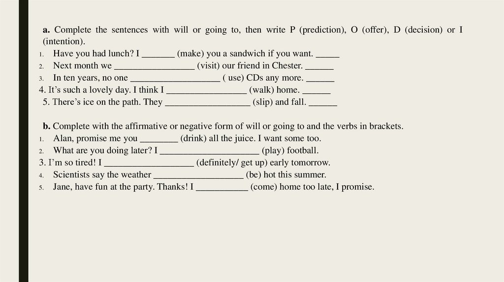
a. Complete the sentences with will or going to, then write P (prediction), O (offer), D (decision) or I(intention).
1.
Have you had lunch? I _______ (make) you a sandwich if you want. _____
2. Next month we _________________ (visit) our friend in Chester. ______
3.
In ten years, no one ___________________ ( use) CDs any more. ______
4. It’s such a lovely day. I think I _________________ (walk) home. ______
5. There’s ice on the path. They __________________ (slip) and fall. ______
b. Complete with the affirmative or negative form of will or going to and the verbs in brackets.
1.
Alan, promise me you ________ (drink) all the juice. I want some too.
2.
What are you doing later? I _____________________ (play) football.
3. I’m so tired! I ___________________ (definitely/ get up) early tomorrow.
4.
Scientists say the weather ___________________ (be) hot this summer.
5.
Jane, have fun at the party. Thanks! I ___________ (come) home too late, I promise.
12.
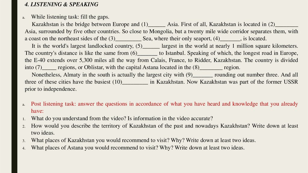
4. LISTENING & SPEAKINGWhile listening task: fill the gaps.
Kazakhstan is the bridge between Europe and (1)______ Asia. First of all, Kazakhstan is located in (2)________
Asia, surrounded by five other countries. So close to Mongolia, but a twenty mile wide corridor separates them, with
a coast on the northeast sides of the (3)_________ Sea, where their only seaport, (4)_______, is located.
It is the world's largest landlocked country, (5)______ largest in the world at nearly 1 million square kilometers.
The country's distance is like the same from (6)_______ to Istanbul. Speaking of which, the longest road in Europe,
the E-40 extends over 5,300 miles all the way from Calais, France, to Ridder, Kazakhstan. The country is divided
into (7)_____ regions, or Oblistar, with the capital Astana located in the (8)________ region.
Nonetheless, Almaty in the south is actually the largest city with (9)_______ rounding out number three. And all
three of these cities have the busiest (10)_________ in Kazakhstan. Now Kazakhstan was part of the former USSR
prior to independence.
a.
a.
1.
2.
3.
4.
Post listening task: answer the questions in accordance of what you have heard and knowledge that you already
have:
What do you understand from the video? Is information in the video accurate?
How would you describe the territory of Kazakhstan of the past and nowadays Kazakhstan? Write down at least
two ideas.
What places of Kazakhstan you would recommend to visit? Why? Write down at least two ideas.
What places of Astana you would recommend to visit? Why? Write down at least two ideas.
13.
SELF – STUDYa. Make a presentation on the theme “Geography of ESC” (Canada, USA, Australia, New
Zealand, South Africa) according to the plan.
1.
Geographical position. 4. Territory, population.
2.
Borders
5. Climate.
3.
Some geographical facts about oceans, rivers, lakes, mountains. 6. Other facts
b. Write an essay on the theme “The features of the geographical position of the country
determine the main features of the nature of the country’s territory.” (Compare Kazakhstan
and ESC)