
»")

.The district center is the village of")


 География
Похожие презентации:


Verkhnevilyuisky ulus
1. Verkhnevilyuisky ulus
Completed: a student ofthe 2nd course agro16
Afanasevа V.E.
Checked: Savvinova A.V.
2. Flag of the municipal formation "the verkhnevilyuysky ulus (district)»
Flag of the municipal formation "theverkhnevilyuysky ulus (district)»
3. Description and symbolism
Flag of the municipal district "verkhnevilyuysky ulus (district)"is a flag of rectangular shape. In the middle of the flag blue
color is an image of the lyre motif, the Yakut national pattern
of "Ki±R, ojuu" (floral pattern), which is also depicted on the
municipal coat of arms. The ornament is of a birch bark
pattern in the form of a cow, horse and double-headed
arrows. Ornament cattle refers to livestock, the agricultural
character of the district. Ornament the two-headed horse
means the equality of the two branches of government:
legislative and Executive. The arrow indicates the aspiration of
the authorities to go to the same goal. Manes of horses —
sowing of cereals. Internal ornament plants — the younger a
bright future district. Along the shaft of the flag is placed the
diamonds in a special styling similar to their styling the State
emblem of the Republic of Sakha (Yakutia), which represent
the administrative-territorial belonging municipal district to
the "diamond province" of the Republic of Sakha (Yakutia).
4. Verkhnevilyuysky ulus is one of the districts of the Republic of Sakha (Yakutia).The district center is the village of
verkhnevilyuyskStatus municipal district.
Included in Yakutia.
Includes 21 municipalities.
Administrative center the village of
verkhnevilyuysk.
Head of administration Poskachin Vladimir.
Official language Yakut, Russian.
Population (2010) 21 279[1]
Area 43 170 km2
Latitude Sixty three
Longitude One hundred twenty
5. Geography
Territory — 43,17 thousand km2. Bounded onthe North from the Olenek, in North-East of the
Vilyui, in the South-East from the Mountain to the
South, Olyokminsky, in the South-West, Suntarsky,
on the West Nyurbinsky ulus.Ulus is located on
the middle reaches of the river Vilyui. Large
tributaries flowing through the territory of the
ulus: Chybyda, Tucan, Tongue. Like most areas of
North and Central Yakutia, lies in a region of
"permafrost". The climate is continental, in winter
the temperature reaches 60 degrees below zero
Celsius and in summer up to +33.
6. Population
Population — 21496 man(2007). Population density
of 0.5 persons/km2.Ethnic
composition of the district
according to the census of
2002: the Yakuts — 20855
person (97,53 %), Russian
— 223 people (1,04 %),
Evenks 112 (0,52 %), evens
— 54 persons (0,25 %)
and other nationalities —
139 (0,66 %).
7. Administrative division
The composition of the district consists of 21 municipalitiesand 29 town uniting points[2]:
rural settlement Balagansky nasleg (village Balagannakh),
rural settlement Boturussky nasleg (village Botou, village
Ketereh),
rural settlement Barganski nasleg (village Byrakan),
rural settlement verkhnevilyuysky nasleg (village of
verkhnevilyuysk),
rural settlement Talarski nasleg (village Daler, village
Michagan, village Kulisnyh),
rural settlement Duracinsky nasleg (village of Gulluk, village
Buradah),
rural settlement Adygeiskiy nasleg (village of St. Andrew, the
village of Kudu),
rural settlement Kentucky nasleg (village Haryyalah),
8.
rural settlement Kyrykyyskaya nasleg (village Karaky),rural settlement Magalski nasleg (village Kharbala, the village of
Csenger),
rural settlement Mayskiy nasleg (village of sayylyk, the village
May),
rural settlement, Nam nasleg (village of Khomustakh),
rural settlement Ochojski nasleg (village of Lippe-atakh ),
rural settlement Oretsky nasleg (village Orget),
rural settlement Organski nasleg (village of the Oros),
ural settlement Sturgulewski nasleg (village Bagadia, the village
of Keng-kyuyel'),
rural settlement Talakansky nasleg (village Thamalakane),
rural settlement Tubulence nasleg (village Twobuy),
rural settlement Kharbalakhskiy nasleg (village of Kul),
rural settlement Homestake nasleg (village of Khomustakh),
rural village Khori nasleg (village Khoro).
9. Economy
Agriculture Theeconomy is based on
agriculture. The main
branch of livestock
breeding (meat and
milk cattle, beef herd
horse breeding), fur
farming; cultivated
crops, potatoes,
vegetables.
Agricultural land
amount to 69.3
thousand hectares.
10.
Transport andcommunications .Road
and river transport,
airport, Telegraph,
telephone, Internet, in
2005, the pipeline. On the
territory of the ulus of
the motorway connecting
the main cities of the
Republic of Yakutsk and
Mirny. There is a ferry
(June — October), ice
(December — April) the
crossing of the Vilyui.
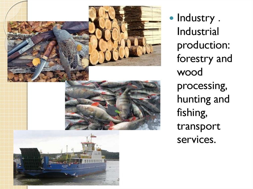
11.
Industry .Industrial
production:
forestry and
wood
processing,
hunting and
fishing,
transport
services.
12. Education
Despite the relatively smallsize of the area is one of the
main "suppliers" of the
intellectual elite of the
Republic. Without belittling
the merits of other schools of
the district, we note that the
main source of manpower is
the Republican school named
national teacher of the USSR
Mikhail A. Alekseev, the
founder of physicomathematical movement in
Yakutia. Graduates now work
not only throughout Yakutia
and Russia, but also in many
countries of Europe and
America.
13. Famous people
Zolotarev, NikolaiGavrilovich (19081995) — the Yakut
writer, better known
under the pseudonym
Nicholas Yakut
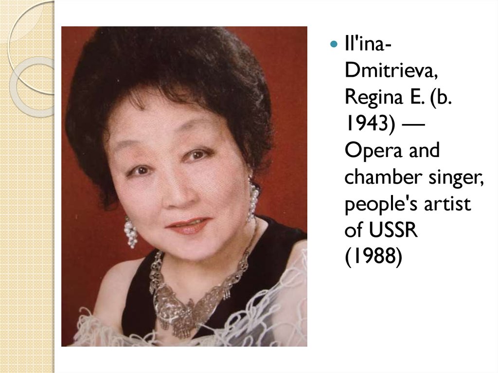
14.
Il'inaDmitrieva,Regina E. (b.
1943) —
Opera and
chamber singer,
people's artist
of USSR
(1988)