


 Информатика
Похожие презентации:


")


Spatial data visualization for SDI
1.
1Theme 5. SPATIAL DATA VISUALIZATION FOR SDI
2.
25.1. General provisions on spatial data visualization for
SDI as Web Mapping
1. The primary view of geographic data has historically been
through maps.
2. In the context of SDIs, it is increasingly useful to provide
mapped or graphical views of spatial data through online
mapping interfaces.
3. This can satisfy many of the needs of novice or browse
users of data without requiring download of the full data.
4. Although it is not a replacement for direct data access, it
satisfies a broad requirement for public interaction with
geospatial information.
3.
35. Maps can quickly portray a large amount of information to
the inquirer.
6. The rise of the Internet and in particular the World Wide
Web has allowed information providers to harness this
technology to the conventional stove-pipe GIS systems and
data warehouses.
7. This theme describes:
1) Current best practice in On-line (Web) Mapping;
2) The results of the OpenGIS Consortium in realizing
simple interoperability through a public Web Mapping
specification that is also a draft ISO International Standard.
4.
45.2. Context and rationale of Web Mapping
1. The rise of the Internet and specifically the World Wide
Web (WWW) has created expectations for ready access to
spatial information on the Web through a common web
browser.
2. Mapping on the Web includes:
1) The presentation of general purpose maps to display;
2) Interactive and customizable mapping tools.
3. The intention of online or Web Mapping is to portray
spatial information quickly and easily for most users,
requiring only map reading skills.
5.
54. Web Mapping Services can be discovered through online
directories that serve both spatial data (through metadata) and
services information (see for example the OGC Catalogue
Services draft specification).
5. In fact, Web Mapping services are often used to assist
users in spatial search systems, showing geographic context
and extent of relevant data against base map reference data.
6. Web Mapping often is implemented as a set of proprietary systems.
7. Because of this obvious particular limitation the Open GIS
Consortium developed a non-proprietary Web Mapping
approach based on the concept of interoperability.
8. The topic of this theme is not complex on-line GIS, but
simple Web Mapping concepts and tools, i.e. part of a
portrayal service to show spatial information on-line when
the information originates from several discrete data/map
servers (commonly from different organizations).
6.
65.3. Open GIS Web Mapping activities
1. The sudden rise of Web Mapping over the last several
years is demonstrated in the interoperability vision held by
the Open GIS Consortium’s Interoperability Program
initiatives.
2. In the OGC, expert GIS and Web Mapping technology
users work with:
– GIS software vendors;
– Earth imaging vendors;
– Database software vendors;
– Integrators;
– Computer vendors;
– Other technology providers.
7.
73. Consensus among vendors in the OGC’s Web Mapping
Testbed has created ways for vendors to write software that
enables users to immediately overlay and operate on views of
digital thematic map data:
– From different online sources;
– Offered though different vendor software.
4. The Web Mapping Testbed has delivered, among other
specifications, a set of common interfaces for communicating
a few basic commands/ parameters that enable automatic
overlays.
5. This set of interfaces:
1) Is known as the OpenGIS Web Mapping Service
(WMS) Interfaces Implementation Specification;
2) Was developed by over 20 participating organizations.
8.
85.4. Web Mapping Service (WMS)
5.4.1. WMS general provisions
1. The WMS is a standard protocol for serving georeferenced
map images over the Internet that are generated by a map
server using data from a GIS database.
2. This service can produce maps drawn into a standard
image format (PNG, GIF, JPEG, etc). based on a standard set
of input parameters.
3. The WMS specification standardizes the way in which
maps are requested by a client and the way that servers
describe their data holdings.
9.
94. The resulting map:
1) Can contain "transparent" pixels where there is no
information and thus several independently drawn maps can
be laid on top of each other to produce an overall map;
2) This is possible even when the maps come from
different Web Map Servers.
5. The WMS specification also supports use of vector-based
graphical elements in either Scalable Vector Graphics (SVG)
or Web Computer Graphics Metafile (WebCGM) formats.
6. The WMS specifications offer a way to enable the visual
overlay of complex and distributed geographic information
(maps) simultaneously, over the Internet.
7. Additionally, other OGC specifications will enable the
sharing of geoprocessing services, such as coordinate
transformation, over the WWW.
10.
105.4.2. WMS principal actions
Web Mapping Service refers, at a minimum, to the
following actions:
1. A Client makes requests to one or more Service Registries
(based on the OpenGIS Catalogue Services Specification) to
discover URLs of Web Map Servers containing desired
information.
2. Service Registries return URLs and also information about
methods by which the discovered information at each URL
can be accessed.
3. The client locates one or more servers containing the
desired information, and invokes them simultaneously.
11.
114. As directed by the Client, each Map Server:
1) Accesses the information requested from it;
2) Renders it suitable for displaying as one or more layers
in a map composed of many layers.
5. Map Services provide the display-ready information to the
Client (or Clients), which then display it:
– Clients may display information from many sources in a
single window.
12.
125.4.3. WMS interfaces
1. Defines three interfaces that support Web Mapping:
1) GetMap;
2) GetCapabilities;
3) GetFeatureInfo.
2. GetMap specifies map request parameters that allow
multiple servers to produce different map layers for a single
client.
3. GetCapabilities explains what a map server can do (so
integrators know what to ask for).
4. GetFeatureInfo specifies how to ask for more information
about web map features.
13.
135. The WMS application domains are:
1) Business siting, market research, and other business
geographic applications;
2) Cable, microwave, and cellular transmission installation
planning;
3) Civil engineering;
4) Education/training, distance learning, multi-disciplinary
research collaboration;
5) Electronic libraries, electronic museums and galleries;
6) Emergency road services and 911 emergency response systems;
7) Environmental monitoring, global and local;
8) Facilities management;
14.
149) Global disaster/emergency/crisis management;
10) Health care: telemedicine, better/faster care for rural
trauma victims, patient monitoring, etc.;
11) Intelligent vehicle highway systems (IVHS);
12) Maintenance of one’s information context and
connection (personal logical network) as one moves through
space;
13) Mapping electronic locations of addresses to their
physical locations;
14) Military applications: surveillance, planning, training,
command/control, logistics, targeting;
15) Municipal public works maintenance and administration;
16) Natural resource discovery, exploitation, and
management;
15.
1517) Navigation;
18) Precision farming (GPS-guided controlled delivery of
nutrients and chemicals based on Earth imagery or automated
GPS-located soil or crop sampling);
19) Product distribution/warehousing optimization;
20) Public safety:
– Fire and police departments;
21) Recreation: hiking, boating, etc.;
22) Science:
– Climate research, agronomy, biology, ecology, geology,
and others;
16.
1623) Security monitoring and intrusion response;
24) Special way finding for elderly and disabled;
25) Telecommunications network planning:
– Mobile communications;
26) Transportation planning;
27) Urban and regional planning
28) Water resource management.
17.
175.5. Web Mapping organisational approach
1. Web based mapping provides the functionality to help
discover and visualize spatial information referenced from
Catalogue Service Systems.
2. A Catalogue Service System (described in Theme 4) is
implemented through Internet-based software that allows
users to inventory, advertise, and access metadata and
associated geospatial information within a global framework
of servers.
3. Figure 5.1 shows one scenario of a client accessing a
Catalogue (actually the catalogue implements a Service
Registry) to discover data and Web Mapping services and
then requesting and displaying maps from different servers.
18.
Fig.5.1 – Interaction of web map client with Catalogue and Web Mapping 18Service
19.
194.
1) A Catalogue Service that provides only references to raw
spatial data would be of use to only GIS experts and their
software;
2) By making map displays of spatial information, casual
users can interact with and see spatial data that was
previously only available to GIS experts.
5. Many different GUIs can be built to provide special access
for different categories of user.
6. All the GUIs must use the same protocol agreements to
interact with the map server software.
20.
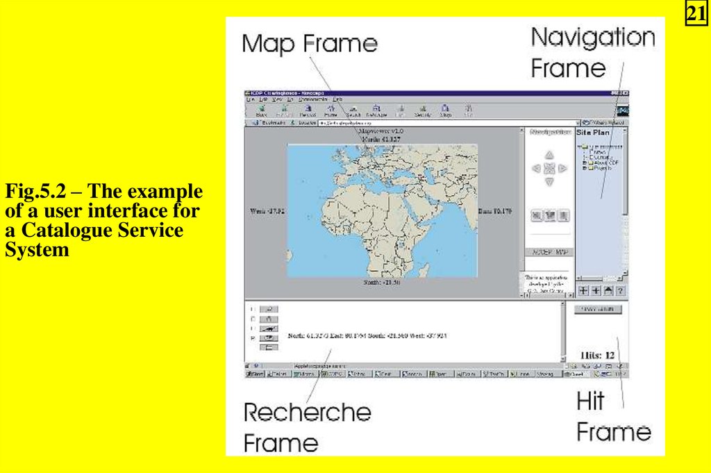
207. Figure 5.2 shows one example of a user interface for a
Catalogue Service System:
1) The Map Frame in Fig.5.2 illustrates the value of
specifying the bounding geometry (box or polygon) for the
spatial part of the query for retrieval within the Catalogue
Service System;
2) Typical dimensions for the query include spatial,
temporal and thematic values;
3) The user also has the option:
a) To specify specific servers;
b) No search all registered servers for the spatial data of
interest;
21.
21Fig.5.2 – The example
of a user interface for
a Catalogue Service
System
22.
224) The Map Frame can also be used for the presentation of
the spatial component of the metadata in maps;
5) The result presentation in a Catalogue Service System
can be installed as:
a) A hidden search variable for further processing;
b) A List or Map in a web browser for visual
presentation;
6) The resulting presentation should be within the bounding
geometry that was specified by the user for the Spatial Query;
8. The success of Web Mapping depends on the use of
consistent metadata standards (See Theme 3).
23.
235.6. Map Servers
1. For the concept of Web Mapping to be successful, a near
global, truly inter-connected series of map servers must be
established through the use of common protocols whether it
be in an intranet, an extranet, or an internet scenario.
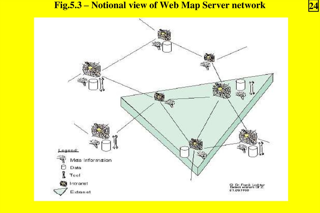
2. Figure 5.3 provides a notional view of such a server
network.
24.
Fig.5.3 – Notional view of Web Map Server network24
25.
253. A Map Server can do three things (functions). It can:
1) Produce a map (as a picture, as a series of graphical
elements, or as a packaged set of geographic feature data);
2) Answer basic queries about the content of the map;
3) Tell other programs:
a) What maps it can produce;
b) Which of those can be queried further.
4. A standard web browser can ask a Map Server to do these
things just by submitting requests in the form of Uniform
Resource Locators (URLs).
5. The content of such URLs depends on which of the three
tasks is requested.
26.
266. All URLs include a Web Mapping Service specification
version number and a request type parameter.
7. In addition, to produce a map, the URL parameters
indicate:
a) Which portion of the Earth is to be mapped;
b) The coordinate system to be used;
c) The type(s) of information to be shown;
d) The desired output format;
c) Perhaps the output size, rendering style, or other
parameters.
8. To query the content of the map, the URL parameters
indicate what map is being queried and which location on the
map is of interest.
27.
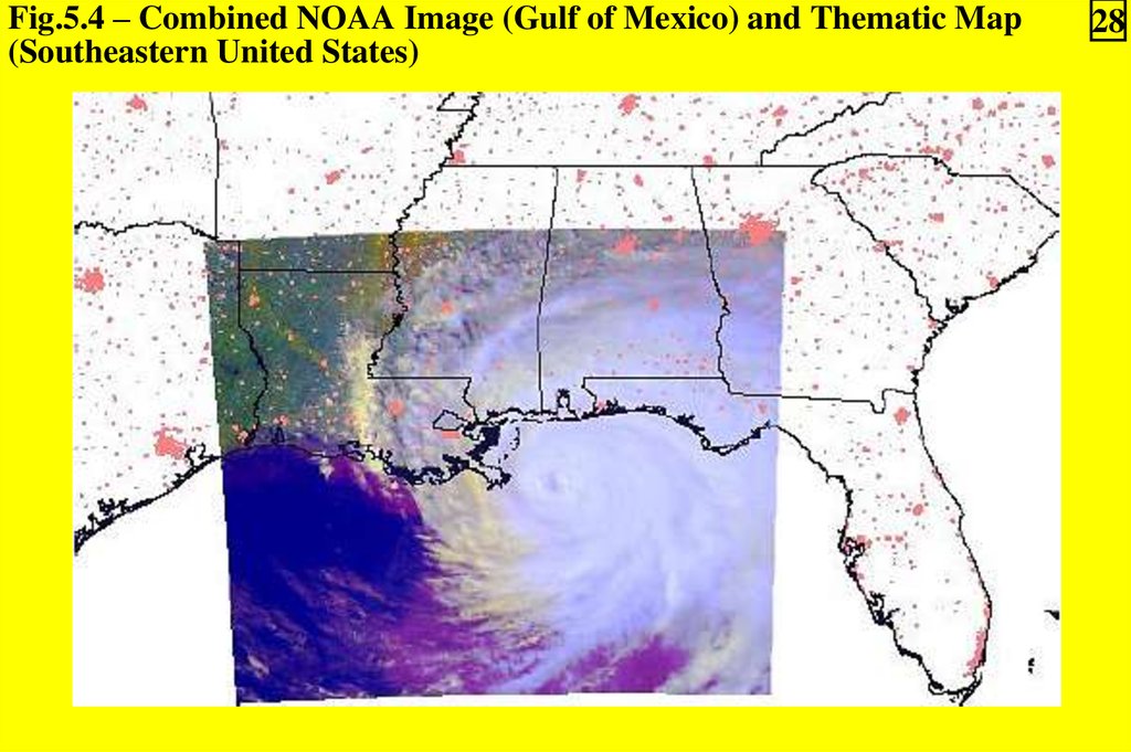
279. To ask a Map Server about its holdings, the URL
parameters includes the "capabilities" request type.
10. Requests to multiple servers can be made to return results
that overlap in the same coordinate system so that map data
can be viewed together even though it may be hosted and
served in different organizations (See the example at Fig.5.4).
11. Each Map Server must be able to provide a list of its
capabilities.
12. That enables the construction of searchable catalogues
that can direct clients to particular Map Servers.
28.
Fig.5.4 – Combined NOAA Image (Gulf of Mexico) and Thematic Map(Southeastern United States)
28
29.
295.7. Software available for the WMS
1. The NASA coordinated Digital Earth project includes
software support for mapping NASA data using the WMS
specification (http://digitalearth.gsfc.nasa.gov/).
2. As open-source implementations of WMS have been
available:
– OGC Web Mapping Service compatible interfaces for:
a) ESRI Map Objects Internet Map Server version 1.1.1;
b) The University of Minnesota "mapserver" product
(http://mapserver.gis.umn.edu).
3. An exhaustive list of software that supports the WMS
specifications is available from the OGC:
http://www.opengis.org/resources/?page=products.